List of State Register of Heritage Places in the City of Bunbury
This is a list of State Register of Heritage Places in the City of Bunbury, Western Australia. The State Register of Heritage Places is maintained by the Heritage Council of Western Australia.
As of 2021, 334 places are heritage-listed in the City of Bunbury,[1] of which 46 are on the State Register of Heritage Places.[2]
List
The Western Australian State Register of Heritage Places, as of 2021, lists the following 46 state registered places within the City of Bunbury:
| Place name | Place # | Street number | Street name | Suburb or town | Co-ordinates | Notes & former names | Photo |
|---|---|---|---|---|---|---|---|
| Paisley Centre | 330 | 1 | Arthur Street | Bunbury | 33.326408°S 115.639470°E | Bunbury Arts Gallery / Art Centre, Bunbury Boys School (former) | 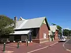 |
| Bunbury Railway Station (former) | 331 | 2 | Camody Place | Bunbury | 33.32427°S 115.63849°E | Station & Bus Terminal,Tourist Bureau, The Old Station, Bunbury Railway | 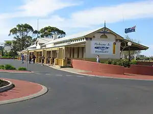 |
| Myrniong | 332 | 50 | Beach Road | Bunbury | 33.336185°S 115.632426°E | Myrniong House | |
| King Cottage | 339 | 77 | Forrest Avenue | Bunbury | 33.341281°S 115.649000°E | Lamorna, Local History Museum | |
| Leschenault Homestead | 344 | Lot 963 | Estuary Drive | Vittoria | 33.329689°S 115.668931°E | Heritage roses, Trees: Olives, Camphor laurel, Oaks | |
| Catholic Cathedral Precinct, Bunbury | 345 | Lot 300 | Money Street | Bunbury | 33.328947°S 115.637092°E | St Patrick's Church, Presbytery | 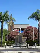 |
| St Patrick's Anglican Church (former) & War Memorial, Rathmines | 348 | 74 | Austral Parade | East Bunbury | 33.331816°S 115.661398°E | Church of Christ, Greek Orthodox Church Services | |
| Bunbury Court House site & current Court House | 352 | 3 | Stephen Street | Bunbury | 33.326329°S 115.637339°E | ||
| Bunbury Municipal Offices (former) | 353 | 3 | Stephen Street | Bunbury | 33.326686°S 115.636022°E | Bunbury Court House |  |
| Prince of Wales Hotel | 354 | 41 | Stephen Street | Bunbury | 33.326433°S 115.638453°E | 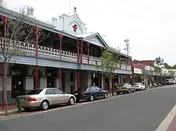 | |
| The Residency, Bunbury | 355 | 55 | Stirling Street | Bunbury | 33.327447°S 115.643353°E | ||
| House at 84 Stirling Street | 359 | 84 | Stirling Street | Bunbury | 33.326850°S 115.646611°E | ||
| House at 10 Turner Street | 366 | 10 | Turner Street | Bunbury | 33.328111°S 115.635781°E | ||
| Grand Central Hotel | 369 | 83 | Victoria Street | Bunbury | 33.323705°S 115.636616°E | Moreton Bay Fig Tree | 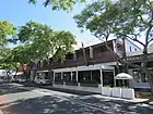 |
| Solicitor's Rooms (former), Bunbury | 370 | 99 | Victoria Street | Bunbury | 33.324098°S 115.636623°E | Apex/Lotteries House, Citizens Advice Bureau, Stanley, Money & Walker Solicitors Office | 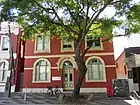 |
| WA Bank (former), Bunbury | 371 | 101 | Victoria Street | Bunbury | 33.324219°S 115.636631°E | Bank of New South Wales (NSW), Lotteries House, Bunbury District Employment Office | 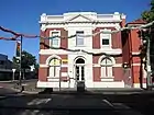 |
| Lyric Theatre (former) | 374 | 73-77 | Victoria Street | Bunbury | 33.328947°S 115.637092°E | Goldfields Theatre, Webster's Dance Hall, Bill Brown's Furniture Store | _Bunbury.JPG.webp) |
| Cronshaw's Store | 375 | 103-107 | Victoria Street | Bunbury | 33.324550°S 115.636600°E | Smith's Buildings, Smith's Drapery | 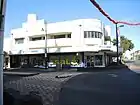 |
| Rose Hotel & Sample Room, Bunbury | 376 | 27 & 29 | Wellington Street | Bunbury | 33.323389°S 115.636694°E | Rose Hotel | 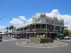 |
| Bunbury Post Office & Bonded Store (former) | 378 | Lot 500 | Stephen Street | Bunbury | 33.326402°S 115.635800°E | Police Office, Bunbury Court House Annexe, SES, Post & Telegraph Office, Police Qtrs, Regional | 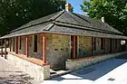 |
| Convent of Mercy Group (former) | 379 | 68 | Wittenoom Street | Bunbury | 33.324974°S 115.635184°E | Convent of Mercy & School St Patricks Convent, Bunbury Regional Art Gallery Sacred Heart HS | 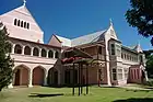 |
| Masonic Hall, Bunbury | 380 | 74 | Wittenoom Street | Bunbury | 33.325789°S 115.635323°E | Freemasons Hall, Wellington Lodge | 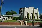 |
| Forrest Homestead | 381 | Lot 91 | South Western Highway | Picton - now Wollaston | 33.353073°S 115.684602°E | Olive Trees & Mill Farm, The Old Place | |
| Picton Inn Hotel | 382 | Kaeshagen Street off Vittoria Road | Picton - now Wollaston | 33.349161°S 115.676478°E | Lawrence's Wayside Inn, Morgan's Inn, Morgan's Wayside Inn, Old Picto | ||
| St Mark's Anglican Church | 383 | Charterhouse Road | Picton - now Wollaston | 33.344436°S 115.666535°E | St. Mark's Anglican Church & former Graveyard, Old Picton Church, St Mark the Evangelist | ||
| Post Box, Kings Cottage | 2535 | 77 | Forrest Avenue | Bunbury | 33.341448°S 115.648986°E | Letter Receiver VR 1897 | |
| Boarding House (former) | 2921 | 155-159 | Stirling Street | Bunbury | 33.328179°S 115.653191°E | Three Dwellings | |
| CBH Grain Silos (former), Bunbury | 2999 | The Strand / Ommanney Street | Bunbury | 33.319164°S 115.638915°E | Co-operative Bulk Handling Silos | ||
| Clifton Residence , Rathmines | 3285 | 9 | Shenton Street | Rathmines, Bunbury | 33.332105°S 115.661692°E | Leston | |
| Bunbury Timber Jetty | 3402 | Lot 1036 | Jetty Road | Bunbury | 33.309902°S 115.643597°E | Outer Harbour Jetty, demolished in 2012 | |
| Bunbury Council Chambers | 3642 | 2 | Stephen Street | Bunbury | 33.325915°S 115.636006°E | Mayoral Suite & Function Room, Bunbury Municipal Chambers | |
| Moreton Bay Fig Tree & Charterhouse site | 4353 | Charterhouse Street | Picton - now Wollaston | 33.344837°S 115.667287°E | Various remnant vegetation | ||
| Commonwealth Bank (former), Bunbury | 4575 | 149 | Victoria Street | Bunbury | 33.32427°S 115.63849°E | Telecom Building, Parliamentary Party Offices | %252C_Bunbury.jpg.webp) |
| Bunbury Senior High School | 5613 | 10 | Haig Crescent | Bunbury | 33.326361°S 115.636661°E | Bunbury High School |  |
| St Boniface Anglican Cathedral | 5667 | 29-33 | Parkfield Street | Bunbury | 33.331468°S 115.637859°E | Calvary Wayside Shrine & Memorial Lawn | |
| Forrest's Leschenault Water Mill & Mill Race - Site | 5676 | South Western Highway on Preston River | Picton | 33.352416°S 115.683818°E | |||
| Lady Mitchell Memorial Child Health Centre, Bunbury | 5682 | 2 | Prosser Street | Bunbury | 33.337921°S 115.640790°E | Lady Mitchell Memorial Infant Health Centre, Bunbury Child Health Centre | |
| Anzac Park, Bunbury | 5700 | Corner | Stirling & Parkfield Streets | Bunbury | 33.327369°S 115.637031°E | Garden of Peace, Bunbury War Memorial & Anzac Park | 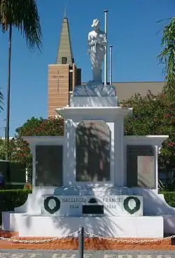 |
| Red Mill Store | 5710 | 59-61 | Stirling Street | Bunbury | 33.327424°S 115.643969°E | Edward Crossley's Ironmongery & Builders' Supply, Chadd & Whitty's Store | |
| Rose Hotel Bottle Shop & Sample Room | 5739 | 31 | Wellington Street | Bunbury | 33.323389°S 115.636694°E |  | |
| Bunbury Women's Club | 7166 | 19 | Prinsep Street | Bunbury | 33.325468°S 115.638054°E | Anglican Deanery (former), Anglican Rectory (former) | 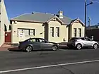 |
| St Patrick's Roman Catholic Cathedral | 18392 | 18 | Parkfield Street | Bunbury | 33.328933°S 115.637045°E | Original building severely damaged and demolished in 2005 | |
| St Patrick's Roman Catholic Parish House | 18393 | Bunbury | Original building severely damaged and demolished in 2005 | ||||
| War Memorial | 18397 | Bunbury | part of St Patrick's Anglican Church (former) & War Memorial, Rathmines (348) | ||||
| Bishopscourt | 18565 | 15 | Cross Street | Bunbury | 33.332169°S 115.638331°E | ||
| St Boniface Anglican Cathedral & Bishopscourt | 18566 | 31 & 33 | Parkfield Street | Bunbury | 33.331468°S 115.637859°E |
References
- "City of Bunbury Heritage Places". inherit.stateheritage.wa.gov.au. Heritage Council of Western Australia. Retrieved 31 January 2021.
- "City of Bunbury State Register of Heritage Places". inherit.stateheritage.wa.gov.au. Heritage Council of Western Australia. Retrieved 31 January 2021.
This article is issued from Wikipedia. The text is licensed under Creative Commons - Attribution - Sharealike. Additional terms may apply for the media files.