List of State Register of Heritage Places in the City of Vincent
This is a list of State Register of Heritage Places in the City of Vincent, Western Australia. The State Register of Heritage Places is maintained by the Heritage Council of Western Australia.
As of 2020, 422 places are heritage-listed in the City of Vincent,[1] of which 63 are on the State Register of Heritage Places.[2]
List
The Western Australian State Register of Heritage Places, as of 2020, lists the following 63 state registered places within the City of Vincent:
| Place name | Place # | Street number | Street name | Suburb or town | Co-ordinates | Notes & former names | Photo |
|---|---|---|---|---|---|---|---|
| Lindsay Street Flour Mill & Bakery Complex | 996 | 12 & 22 | Lindsay Street | Perth | 31.946534°S 115.863702°E | ||
| Baker's Terrace | 1000 | 156-184 | Lake Street | Perth | 31.943277°S 115.859992°E | ||
| Brisbane Street Post Office | 1971 | 115 | Brisbane Street | Perth | 31.943669°S 115.864239°E | North Perth Post Office | |
| Dilhorn House | 2168 | 2 | Bulwer Street | Perth | 31.942312°S 115.866923°E | Army Museum, Loton House, Loton Park | 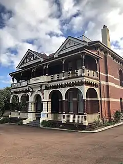 |
| St Alban's Church, Highgate | 2178 | 449 | Beaufort Street | Highgate | 31.940261°S 115.867939°E | ||
| Highgate Primary School | 2180 | 147 | Lincoln Street | Perth | 31.941145°S 115.866367°E | ||
| Sacred Heart Catholic Group, Highgate | 2181 | 40 | Mary Street | Highgate | 31.937280°S 115.868147°E | Consists of Monastery of Our Lady of the Sacred Heart (2182), Sacred Heart Church Hall (13034) and Sacred Heart Church (23930), | |
| Monastery of Our Lady of the Sacred Heart (former) | 2182 | 42 | Mary Street | Highgate | 31.937050°S 115.867581°E | Sacred Heart Convent (former), Sacred Heart Convent & School | |
| St Mary's Catholic Church | 2196 | 40 | Franklin Street | Leederville | 31.927039°S 115.843169°E | ||
| St Mary's Hall | 2202 | 336 | Oxford Street | Leederville | 31.927650°S 115.841569°E | ||
| Leederville Post Office | 2203 | 156 | Oxford Street | Leederville | 31.936242°S 115.841455°E | ||
| North Perth Police Station | 2212 | 81 | Angove Street | North Perth | 31.929281°S 115.855550°E | North Perth Police Station and Quarters | |
| North Perth Post Office (former) | 2215 | 21A | View Street | North Perth | 31.931969°S 115.857039°E | 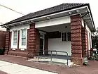 | |
| North Perth Town Hall Complex | 2216 | 24 - 26 | View Street | North Perth | 31.931448°S 115.856654°E | North Perth Lesser Hall, North Perth Main Hall | 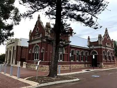 |
| Redemptorist Monastery and Church | 2218 | 190 | Vincent Street | North Perth | 31.935833°S 115.856389°E |  | |
| Charles St Methodist Mission Chapel & Methodist Church | 2237 | 113 | Charles Street | West Perth | 31.941401°S 115.851712°E | Uniting Church and Methodist Mission Chapel, Wesleyan Church and Chapel (former) | |
| Newcastle Street Government School | 2241 | 480 | Newcastle Street | West Perth | 31.941290°S 115.851128°E | Newcastle Street Infants & Seniors School , West Perth School, St Johns C of E School | |
| Perth Oval | 2992 | 27 | Bulwer Street | Perth | 31.945950°S 115.870131°E | Loton Park, Members Equity Stadium, NIB Stadium | 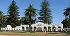 |
| Throssell House, Perth | 2993 | 15 | Throssell Street | Perth | 31.937050°S 115.859450°E | Wedderburn | |
| Terrace Houses, 225-227 Beaufort Street | 3133 | 225 | Beaufort Street | Perth | 31.945765°S 115.864680°E | Two Terrace Houses | |
| Terrace Houses, 235-241 Beaufort Street | 3134 | 235-241 | Beaufort Street | Perth | 31.945468°S 115.864833°E | Terrace Houses, Residences & Goodridge Galleries | 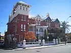 |
| Lincoln Street Ventilation Stack | 3137 | 57 | Lincoln Street | Highgate | 31.942400°S 115.870800°E | Dumas' Folly | 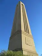 |
| East Perth Power Station | 3318 | 11 | Summers Street | East Perth | 31.946251°S 115.880239°E | 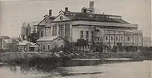 | |
| Anzac Cottage | 3344 | 38 | Kalgoorlie Street | Mount Hawthorn | 31.923499°S 115.834745°E | 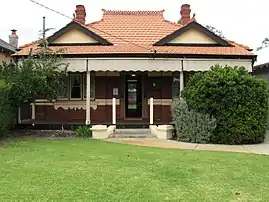 | |
| Shops, 452-460 William Street | 3485 | 452-460 | William Street | Perth | 31.943221°S 115.863196°E | ||
| Loton Park Tennis Club | 3536 | Corner | Bulwer & Lord Streets | Perth | 31.945261°S 115.871700°E | ||
| Beatty Park Leisure Centre & Beatty Park | 3553 | 220 | Vincent Street | North Perth | 31.935556°S 115.848889°E | Beatty Aquatic Centre, City of Perth Aquatic Centre | 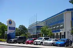 |
| Brookman & Moir Streets Precinct | 3992 | Moir & Brookman Streets & Forbes Road | Perth | 31.943862°S 115.860685°E | |||
| Highgate Hill Police Station, Lockup & Quarters (former) | 4282 | 57 | Lincoln Street | Perth | 31.942836°S 115.870636°E | Highgate Police Station, Lockup & Quarters | |
| Hyde Park | 4634 | Vincent Street | Highgate | 31.937781°S 115.862500°E | Third Swamp,Third Swamp Reserve | 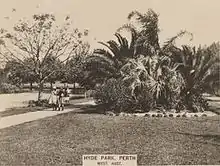 | |
| Maltings Plant (former) | 4648 | 33-35 | Stuart Street | Perth | 31.943134°S 115.856521°E | Union Maltings, Union Brewery, Harwood's Brewery, Perth Pneumatic Maltings | |
| Bowra and O'Dea Beaufort Street | 8586 | 359 | Beaufort Street | Perth | 31.942244°S 115.866944°E | Pensioner Funeral Services, Arthur E. Davies & Co. | |
| Robertson Park and Archaeological Sites | 8705 | 176 | Fitzgerald Street, Randell, Palmerston & Stuart Streets | Perth | 31.940902°S 115.857185°E | Lake Henderson | |
| Aranmore Catholic College Group | 8709 | 30-42 Franklin Street & 338-342 Shakespeare Street | Leederville | 31.927694°S 115.843000°E | Arranmore, St Mary's Convent and School, St Mary's College, Christian Brothers College | ||
| Stables (former), 17 Lindsay Street | 8723 | 15-17 | Lindsay Street | Perth | 31.946189°S 115.863200°E | ||
| Mackays Aerated Waters Factory (former) | 8728 | Oct-22 | Money Street | Perth | 31.945988°S 115.862940°E | Chas Hopkins Office Interiors Bulkstores, Mackay & Co, Mackays Aerated Waters | |
| Oddfellows Hall (former), Leederville | 8736 | 217 | Oxford Street | Leederville | 31.933628°S 115.840938°E | Oddfellows Hall, IOOF Buffaloes Lodge (former) | |
| Serbian Orthodox Church of St. Sava | 8746 | 31 | Smith Street | Highgate | 31.941522°S 115.870564°E | 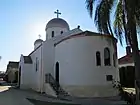 | |
| North Perth Fire Station (former) | 8749 | 21 | View Street | North Perth | 31.932011°S 115.857200°E | 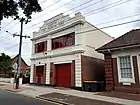 | |
| Drill Hall, Leederville | 8764 | 177 | Oxford Street | Leederville | 31.936144°S 115.840135°E | RAAF Barracks & Drill Hall, Leederville Mechanics' Institute | |
| Dwelling, Caretaker's House, Robertson Park | 11436 | 176 | Fitzgerald Street | North Perth | 31.941147°S 115.855769°E | Robertson Park & Associated Buildings | |
| Parry Street Precinct | 11543 | Parry Street & Pier Street | Perth | 31.948233°S 115.867285°E | |||
| Sacred Heart Church Hall | 13034 | 42 | Mary Street | Highgate | 31.937053°S 115.867584°E | ||
| Walcott Centre | 15731 | 3 | Walcott Street | Mount Lawley | 31.938594°S 115.876186°E | Walcott Street Reception Home, Government Receiving Depot, Child Welfare Rec | |
| Two Attached Houses | 15787 | 147-149 | Parry Street | Perth | 31.947669°S 115.866181°E | ||
| House | 15788 | 145 | Parry Street | Perth | 31.948180°S 115.867170°E | ||
| Two Conjoined Houses | 15789 | 143 | Parry Street | Perth | 31.947739°S 115.866361°E | ||
| Two Attached Houses | 15790 | 139-141 | Parry Street | Perth | 31.947789°S 115.866461°E | ||
| Two Attached Houses | 15791 | 135-137 | Parry Street | Perth | 31.947777°S 115.866646°E | ||
| House | 15793 | 111 | Parry Street | Perth | 31.947650°S 115.866328°E | ||
| Two Attached Houses | 15794 | 107-109 | Parry Street | Perth | 31.948195°S 115.867470°E | ||
| Two Attached Houses | 15795 | 103-105 | Parry Street | Perth | 31.948333°S 115.867565°E | ||
| Houses | 15796 | 99-101 | Parry Street | Perth | 31.948361°S 115.867731°E | ||
| Five Houses | 15797 | 85-93 | Parry Street | Perth | 31.948460°S 115.867925°E | ||
| House | 15798 | 89 | Parry Street | Perth | 31.948492°S 115.867996°E | ||
| North Perth Primary School | 16789 | 3 | Albert Street | North Perth | 31.930627°S 115.855879°E | School of Instrumental Music, North Perth Infants School, Toorak/Woodville PS | |
| Tudor Lodge | 17150 | 57 & 59 | Chelmsford Road | Mount Lawley | 31.935894°S 115.867214°E | Mean-Myne, Tudor Lodge Family & Children's, Services Hostel | |
| North Perth Town Hall - Lesser Hall | 18079 | 20-26 | View Street | North Perth | 31.931449°S 115.856775°E | 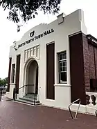 | |
| North Perth Town Hall - Main Hall | 18080 | 20-26 | View Street | North Perth | 31.931449°S 115.856775°E | 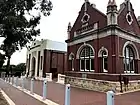 | |
| Sewerage Vent, Northbridge | 23777 | Stuart Street | Northbridge | 31.942898°S 115.858066°E | |||
| Sewerage Vent, Hyde Park, Highgate | 23781 | William Street | Highgate | 31.939793°S 115.864266°E | |||
| Sacred Heart Church | 23930 | 40-42 | Mary Street | Highgate | 31.937280°S 115.868147°E | ||
| Metropolitan Sewerage Vents | 23992 | East & West Perth, Highgate, Northbridge | 31.942898°S 115.858066°E31.939793°S 115.864266°E |
References
- "City of Vincent Heritage Places". inherit.stateheritage.wa.gov.au. Heritage Council of Western Australia. Retrieved 1 May 2020.
- "City of Vincent State Register of Heritage Places". inherit.stateheritage.wa.gov.au. Heritage Council of Western Australia. Retrieved 1 May 2020.
This article is issued from Wikipedia. The text is licensed under Creative Commons - Attribution - Sharealike. Additional terms may apply for the media files.