List of State Register of Heritage Places in the City of Karratha
This is a list of State Register of Heritage Places in the City of Karratha, Western Australia. The State Register of Heritage Places is maintained by the Heritage Council of Western Australia.
As of 2020, 122 places are heritage-listed in the City of Karratha,[1] of which 29 are on the State Register of Heritage Places.[2]
List
The Western Australian State Register of Heritage Places, as of 2020, lists the following 29 state registered places within the City of Karratha:
| Place name | Place # | Location | Suburb or town | Co-ordinates | Built | Stateregistered | Notes | Photo |
|---|---|---|---|---|---|---|---|---|
| Cossack Town Site Precinct | 3239 | Cossack | 20°40′48″S 117°11′24″E | 1870 | 21 April 2006 |
|
 | |
| Cossack School (Ruins) | 3230 | 47 Perserverance Street | Cossack | 20°40′50″S 117°11′06″E | 1896 | 24 March 1992 |
|
|
| Cossack Cemetery | 3232 | Lots 422-423 Settlers Beach Road | Cossack | 20°40′27″S 117°11′35″E | 24 March 1992 |
|
 | |
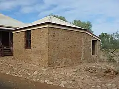
| Customs House & Bond Store | 2345 | Lot 442 Pearl Street | Cossack | 20°40′44″S 117°11′20″E | 1895 | 24 March 1992 |
|
 |
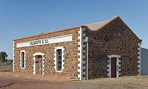
| Galbraith's Store | 2344 | Lot 444 Pearl Street | Cossack | 20°40′40″S 117°11′16″E | 1890 | 24 March 1992 |
|
 |
| Jarman Island Lighthouse & Quarters | 2337 | Jarman Island | Cossack | 20°39′31″S 117°13′02″E | 1888 | 12 May 2000 |
|
 |
| Jarman Island Lighthouse | 25070 | Jarman Island | Cossack | 20°39′28″S 117°13′03″E |
|
|||
| Jarman Island Quarters | 25071 | Cossack | 20°39′31″S 117°13′02″E |
|
||||
| Land Backed Wharf | 3231 | Lot 446 Cossack Road | Cossack | 20°40′47″S 117°11′20″E | 1894 | 24 March 1992 |
|
 |
| The Old Court House | 2346 | Lots 106-107 Pearl Street | Cossack | 20°40′41″S 117°11′18″E | 1885 | 24 March 1992 |
|
 |
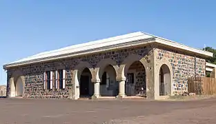
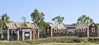
| Police Quarters, Lockup & Service Buildings | 3229 | between Perseverance Street & Cossack Road | Cossack | 20°40′43″S 117°11′21″E | 1890 | 24 March 1992 |
|
.jpg.webp) |
| Cookhouse | 4018 | Perserverance Street | Cossack | 20°40′43″S 117°11′21″E | 1898 |
|
||
| Three Toilets | 4019 | Perserverance Street | Cossack | 20°40′43″S 117°11′21″E | 1898 |
|
||
| Post and Telegraph Office | 2347 | Corner Pearl & Perseverance Street | Cossack | 20°40′43.1″S 117°11′19.7″E | 1884 | 24 March 1992 |
|
 |
| Kitchen | 4016 | Corner Pearl Street & The Strand | Cossack | 20°40′43″S 117°11′20″E | 1884 |
|
 | |
| Service Building | 4017 | Corner Pearl Street & The Strand | Cossack | 20°40′43″S 117°11′20″E | 1884 |
|
||
| Registrar's Office and Residence | 3233 | Pearl Street | Cossack | 20°40′45″S 117°11′19″E | 1895 | 24 March 1992 |
|
|
| Mercantile Store (ruins) | 8675 | Cossack | 20°40′45″S 117°11′19″E | 1895 |
|
 | ||
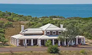
| Cooya Pooya Station | 3376 | 35 km South of Roebourne | Cooya Pooya | 21°02′02″S 117°08′20″E | 1882 | 2 September 1998 |
|
|
| Roebourne Police Station, Gaol & Court House Precinct | 2319 | Bounded by Queen, Hampton & Victoria Street and Carnarvon Terrace | Roebourne | 20°46′40″S 117°08′40″E | 1886 | 20 October 1995 |
|
|
| Roebourne Courthouse | 25072 | Lot 785 Queen Street | Roebourne | 20°46′42″S 117°08′38″E | 1886 |
|
.jpg.webp) | |
| Roebourne Gaol | 25074 | 786 Carnarvon Terrace | Roebourne | 20°46′43″S 117°08′40″E | 1896 |
|
 | |
| Roebourne Police Station (1896) | 25073 | Lot 785 Queen Street | Roebourne | 20°46′40″S 117°08′43″E | 1896 |
|
||
| Dalgety House | 13254 | 48 Roe Street | Roebourne | 20°46′30″S 117°08′47″E | 1892 | 11 August 2009 |
|
|
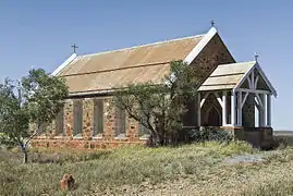
| Holy Trinity Anglican Church | 2332 | Hampton Street | Roebourne | 20°46′49″S 117°08′39″E | 1895 | 29 September 1998 |
|
 |
| Roebourne Hospital Group | 2339 | 51-61 Hampton Street | Roebourne | 20°46′35″S 117°08′38″E | 1887 | 30 June 2014 |
|
|
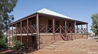
| Mount Welcome House | 2343 | 64 Hampton Road | Roebourne | 20°46′41″S 117°08′35″E | 1864 | 31 October 1998 |
|
|
| Roebourne Primary School & Quarters (former) | 2341 | 54 Hampton Street | Roebourne | 20°46′34″S 117°08′35″E | 1891 | 30 August 2002 |
|
|
| Roebourne Post Office | 2334 | 69 Sholl Street | Roebourne | 20°46′34″S 117°08′43″E | 1887 | 2 September 1998 |
|
.jpg.webp) |
References
- "City of Karratha Heritage Places". inherit.stateheritage.wa.gov.au. Heritage Council of Western Australia. Retrieved 8 March 2020.
- "City of Karratha State Register of Heritage Places". inherit.stateheritage.wa.gov.au. Heritage Council of Western Australia. Retrieved 8 March 2020.
This article is issued from Wikipedia. The text is licensed under Creative Commons - Attribution - Sharealike. Additional terms may apply for the media files.