List of historic places in Parkland Region, Manitoba
This is a list of historic places in Parkland Region, Manitoba entered on the Canadian Register of Historic Places, whether they are federal, provincial, or municipal.
List of historic places
| Name | Address | Coordinates | IDF | IDP | IDM | Image | |
|---|---|---|---|---|---|---|---|
| Inglis Grain Elevators National Historic Site of Canada | , Inglis, MB | 50°56′39″N 101°14′56″W | 7875 | 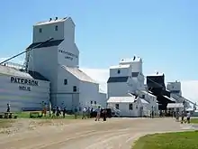 More images | |||
| Ukrainian Greek Orthodox Church of the Ascension | , Silver Creek, MB | 50°44′06″N 101°01′01″W | 9026 |  | |||
| Lakedale Holy Ghost Ukrainian Catholic Church | , Silver Creek, MB | 50°47′01″N 100°58′26″W | 14523 | | |||
| Ukrainian People's Home of Ivan Franko | Wright Avenue, Silver Creek, MB | 50°44′03″N 101°01′05″W | 2910 | | |||
| Angusville Municipal Building | 235 Main Street, Silver Creek, MB | 50°44′03″N 101°01′12″W | 8235 | | |||
| North American Lumber Co. Building | 162 - 2nd Street, Binscarth, MB | 50°37′33″N 101°17′13″W | 3218 | | |||
| Bank of Montreal Building | 5 Railway Avenue North, Ethelbert, MB | 51°32′N 100°24′W | 4174 | | |||
| Ruskin School | , Ethelbert, MB | 51°30′49″N 100°26′20″W | 8230 | | |||
| Makaroff Hall | , Shell River, MB | 51°21′03″N 101°30′29″W | 8455 | | |||
| Ukrainian Greek Orthodox Church of St. John the Baptist | , Ethelbert, MB | 51°39′16″N 100°27′36″W | 8864 | | |||
| Garland United Church | , Ethelbert, MB | 51°39′09″N 100°27′36″W | 8865 | | |||
| Toutes Aides Roman Catholic Church | , Lawrence, MB | 51°29′13″N 99°32′00″W | 6262 | | |||
| Ruthenian Greek Catholic Church of the Blessed Virgin Mary | , Lawrence, MB | 51°27′17″N 99°31′38″W | 6264 | | |||
| St. Margaret's Anglican Church | 112 Willow Avenue, Mountain (North), MB | 52°40′56″N 101°06′36″W | 9025 | | |||
| Griswold United Church | Patterson Street, Sifton, MB | 49°43′34″N 100°31′12″W | 4306 | | |||
| Tummel United Church | , Shell River, MB | 51°08′24″N 101°23′53″W | 9441 | | |||
| Horod School | NE 22-19-21W, Park (South), MB | 50°39′07″N 100°18′00″W | 3749 | | |||
| Sts. Peter and Paul Roman Catholic Church | SE 7-19-21 WPM, Park (South), MB | 50°37′04″N 100°22′12″W | 4828 | | |||
| Assumption of the Blessed Virgin Mary Ukrainian Catholic Church | , Park (South), MB | 50°42′41″N 100°26′20″W | 6256 | | |||
| Ruthenian Greek Catholic Church of the Ascension | , Park (South), MB | 50°38′19″N 100°10′16″W | 6291 | | |||
| Sts. Peter and Paul Ukrainian Orthodox Church | , Park (South), MB | 50°40′57″N 100°29′06″W | 16347 | | |||
| Sts. Peter and Paul Ukrainian United Church | , Shellmouth-Boulton, MB | 51°00′27″N 101°12′50″W | 6533 | | |||
| St. Elijah Romanian Orthodox Church | SW 24-23-24 W, Shellmouth-Boulton, MB | 50°59′36″N 101°16′08″W | 3907 | | |||
| Inglis Grain Elevator Row | Railway Avenue, Shellmouth-Boulton, MB | 50°56′39″N 101°14′49″W | 4166 | | |||
| Shellmouth United Church | , Shellmouth-Boulton, MB | 50°56′00″N 101°28′41″W | 5371 | | |||
| Paulencu House | , Shellmouth-Boulton, MB | 50°59′36″N 101°16′12″W | 6435 | | |||
| Our Lady of Seven Sorrows Roman Catholic Church | , Mountain (South), MB | 52°00′15″N 100°09′04″W | 6266 | | |||
| St. Michael's Ukrainian Catholic Church | NW 20-26-20 WPM, Dauphin, MB | 51°16′12″N 100°14′56″W | 4107 | | |||
| Elaschuk House | , Roblin, MB | 51°13′45″N 101°15′07″W | 4172 | | |||
| Former Canadian Northern Railway Station | 126 First Avenue, Roblin, MB | 51°13′47″N 101°21′11″W | 6547 | | |||
| South Bay School | , Winnipegosis, MB | 51°40′59″N 100°03′04″W | 6170 | | |||
| Holy Resurrection Russian Orthodox Church | Ogryzlo Street, Dauphin, MB | 51°21′37″N 100°08′20″W | 6259 | | |||
| Tamarisk United Church | , Grandview, MB | 50°11′46″N 100°38′53″W | 5097 | | |||
| Tamarisk School | , Grandview, MB | 51°05′46″N 100°40′12″W | 15281 | 6159 | | ||
| Rhodes Community Hall | , Dauphin, MB | 51°28′31″N 100°31′59″W | 8456 | | |||
| Cromarty School | , Roblin, MB | 51°13′40″N 101°28′08″W | 8457 | | |||
| Ukrainian Greek Orthodox Church of Sts. Peter and Paul | , Dauphin, MB | 51°00′48″N 100°12′11″W | 9422 | | |||
| T.A. Burrows Mill Site | , Grandview, MB | 51°10′47″N 100°42′47″W | 11501 | | |||
| Historic Ukrainian Catholic Church of the Resurrection | 1106 First Street SW, Dauphin, MB | 51°08′27″N 100°03′40″W | 3917 | | |||
| Dauphin Canadian National Railway Station | 103 1st Avenue, Dauphin, MB | 51°09′00″N 100°03′04″W | 3921 | | |||
| Dauphin Town Hall | 104 1st Avenue NW, Dauphin, MB | 51°09′03″N 100°03′04″W | 3974 | | |||
| Former Canadian Northern Railway Station | 101 1st Avenue NW, Dauphin, MB | 51°09′00″N 100°03′04″W | 6496 | More images | |||
| Ukrainian Catholic Church of the Resurrection National Historic Site of Canada | 1106 First Street SW, Dauphin, MB | 51°08′31″N 100°03′43″W | 12283 | | |||
| Negrych Homestead | SE 14-27-22 W, Gilbert Plains, MB | 51°18′24″N 100°27′07″W | 3912 | | |||
| Gilbert Plains Beef Ring Building | , Gilbert Plains, MB | 51°05′36″N 100°27′47″W | 8388 | | |||
| Law Office Building | 510 Main Street, Swan River, MB | 52°06′20″N 101°16′12″W | 8395 | | |||
| Satterthwaite House | , McCreary, MB | 50°42′34″N 99°29′10″W | 5082 | | |||
| Canal School | Railway Street, McCreary, MB | 50°46′27″N 99°29′33″W | 5798 | | |||
| Former Canadian Northern Railway Station | Railway St. (between 1st and 2nd Ave.), McCreary, MB | 50°46′24″N 99°29′25″W | 6630 | | |||
| Torsky Cabin | , Rossburn, MB | 50°44′42″N 100°48′25″W | 6158 | | |||
| Armstrong Farm Site | , Rossburn, MB | 50°35′57″N 100°47′20″W | 6257 | | |||
| Ukrainian Pioneer Mass Grave Site | , Rossburn, MB | 50°38′28″N 100°35′38″W | 6258 | | |||
| Sts. Peter and Paul Ukrainian Catholic Church | , Rossburn, MB | 50°41′57″N 100°40′34″W | 6263 | | |||
| Our Lady of the Assumption Roman Catholic Church | , Rossburn, MB | 50°38′20″N 100°33′14″W | 6290 | | |||
| Ukrainian Greek Orthodox Church of the Assumption of St. Mary | , Rossburn, MB | 50°47′08″N 100°51′25″W | 6491 | | |||
| Marconi School | NW 23-20-23 WPM, Rossburn, MB | 50°44′24″N 100°34′34″W | 3750 | | |||
| St. Michael's Ukrainian Catholic Church | , Rossburn, MB | 50°40′10″N 100°33′18″W | 6673 | | |||
| Glen Elmo School | , Rossburn, MB | 50°50′39″N 100°50′02″W | 6916 | | |||
| Smellie Bros. and Co. Store | 300 Main Street, Russell, MB | 50°14′49″N 99°50′36″W | 2715 | | |||
| Harley House | 515 2nd Street North, Swan River, MB | 52°06′20″N 101°15′54″W | 16348 | | |||
| Superintendent's Residence and Works Garage | Riding Mountain National Park, Wasagaming, MB | 50°40′33″N 99°54′51″W | 3457 |  More images | |||
| Staff Residence Building B-15 | 150 Ta-wa-pit Drive, Riding Mountain National Park, Wasagaming, MB | 50°41′10″N 99°58′05″W | 3459 |  More images | |||
| Warden's Station Residence No. 1, Building B-18 | Riding Mountain National Park, Wasagaming, MB | 50°53′00″N 100°15′00″W | 4271 | | |||
| Bandstand (B9) | Riding Mountain National Park, Wasagaming, MB | 50°53′00″N 100°15′00″W | 4278 | 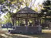 More images | |||
| Superintendent's Residence | , Wasagaming, MB | 50°41′10″N 99°58′05″W | 3456 | | |||
| Accountant's Residence | 154 Columbine Street, Wasagaming, MB | 50°53′00″N 100°15′00″W | 4276 | 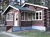 More images | |||
| Casa Loma, Building (A2) | 154 Wasagaming Drive, Wasagaming, MB | 50°53′00″N 100°15′00″W | 4280 | 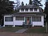 More images | |||
| Jamboree Hall, Building B-10 | , Wasagaming, MB | 50°53′00″N 100°15′00″W | 4282 | | |||
| Tennis Clubhouse (B-6) | Riding Mountain National Park, Wasagaming, MB | 50°53′00″N 100°15′00″W | 4284 | 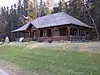 More images | |||
| Riding Mountain Park East Gate Registration Complex National Historic Site of Canada | Norgate Road, Riding Mountain National Park, Wasagaming, MB | 50°41′00″N 99°33′19″W | 10550 | 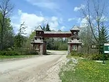 | |||
| East Gate Entrance Building | Highway 10, Riding Mountain National Park, Wasagaming, MB | 50°41′00″N 99°33′19″W | 9479 | | |||
| Fire Hall (B-3) | 126 Tawapit Drive, Riding Mountain National Park, Wasagaming, MB | 50°53′00″N 100°15′00″W | 9480 | 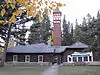 More images | |||
| Doctor’s Residence and Clinic (C5) | 140 Ta-wa-pit Drive, Wasagaming, MB | 50°53′00″N 100°15′00″W | 9483 | 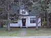 More images | |||
| Golf Clubhouse (B7) | Riding Mountain National Park, Wasagaming, MB | 50°53′00″N 100°15′00″W | 9783 | | |||
| Grey Owl's Cabin (B21) | , Wasagaming, MB | 50°41′10″N 99°58′05″W | 9915 | | |||
| Royal Canadian Air Force Cottage (B16) | , Wasagaming, MB | 50°53′00″N 100°15′00″W | 9917 | | |||
| Whirlpool Wardens' Residence | Riding Mountain Park East Gate Registration Complex National Historic Site of Canada, Wasagaming, MB | 50°41′00″N 99°33′22″W | 9918 | | |||
| Gate Keeper's Residence (B20) | Riding Mountain National Park, Wasagaming, MB | 50°41′00″N 99°33′22″W | 11181 | | |||
| Interpretive Centre B1 | Riding Mountain National Park, Wasagaming, MB | 50°53′00″N 100°15′00″W | 14829 | 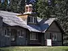 | |||
| Park Administration Building | Riding Mountain National Park, Wasagaming, MB | 50°59′06″N 100°03′47″W | 2888 | 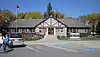 More images |
See also
| Wikimedia Commons has media related to Cultural heritage monuments in Manitoba. |
This article is issued from Wikipedia. The text is licensed under Creative Commons - Attribution - Sharealike. Additional terms may apply for the media files.