List of historic places in Central Plains Region, Manitoba
This is a list of historic places in Central Plains Region, Manitoba entered on the Canadian Register of Historic Places, whether they are federal, provincial, or municipal.
List of historic places
| Name | Address | Coordinates | IDF | IDP | IDM | Image | |
|---|---|---|---|---|---|---|---|
| Fannystelle School | , Grey, MB | 49°44′42″N 97°46′39″W | 6589 |  | |||
| Convent of the Sisters of the Holy Names of Jesus and Mary | 432 Joubert Street North, St. Jean Baptiste, MB | 49°26′42″N 96°59′31″W | 3857 | | |||
| Sacred Heart of Jesus Roman Catholic Church | 37 Church Avenue, Grey, MB | 49°44′44″N 97°46′48″W | 8495 | | |||
| Grace Evangelical Lutheran Church | 408 Main Street, Lakeview, MB | 50°23′04″N 98°40′32″W | 6756 | | |||
| Moffatt Barn | , Lakeview, MB | 50°15′05″N 98°43′42″W | 8156 | | |||
| Arden Mound and Camp Site | , Lansdowne, MB | 50°14′00″N 96°15′15″W | 6974 | | |||
| Tenby School | Main Street, Lansdowne, MB | 50°30′03″N 99°07′58″W | 5774 | | |||
| Scott House | , Lansdowne, MB | 50°24′37″N 99°21′18″W | 7013 | | |||
| Austin Elevator | Manitoba Agricultural Museum, Provincial Highway 34, North Norfolk, MB | 49°55′31″N 98°56′48″W | 20205 | | |||
| MacGregor Canadian Pacific Railway Water Tower | Manitoba Agricultural Museum, Provincial Highway 34, North Norfolk, MB | 49°55′31″N 98°56′45″W | 20206 | | |||
| Holland Emmanuel Historical Church | 114 Barr Street, Victoria, MB | 49°35′46″N 98°52′52″W | 19369 | | |||
| Mahon Home | , Victoria, MB | 49°35′42″N 98°58′50″W | 6480 | | |||
| Young House | SW 27-7-12 W, Victoria, MB | 49°35′29″N 99°01′30″W | 5773 | | |||
| Qually Brothers Store | 48 Qually Road, Cartier, MB | 49°53′N 97°38′W | 9953 | | |||
| St. Paul's Anglican Church | 4813 PTH 26, St. François Xavier, MB | 50°02′59″N 97°50′13″W | 2735 | | |||
| Warkentin Blacksmith Shop | 2172 PTH 26, St. François Xavier, MB | 49°57′50″N 97°37′42″W | 2739 | | |||
| Grey Nuns' Convent | 1060 Highway 26, Cartier, MB | 49°54′45″N 97°32′21″W | 3885 | | |||
| Galloway Bros Department Store | 37 Morris Avenue, Gladstone, MB | 50°13′42″N 98°57′00″W | 3490 | | |||
| Smith/Arthur Farm Elevator | , Gladstone, MB | 50°13′19″N 98°58′31″W | 6892 | | |||
| Taylor House | 102 1st Street SW, Portage la Prairie, MB | 49°34′52″N 98°10′25″W | 4505 | | |||
| Portage la Prairie Canadian Pacific Railway Station | 301 3rd Street NE, Portage la Prairie, MB | 49°35′04″N 98°10′36″W | 4556 15788 |
4506 | 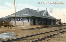 | ||
| Poplar Point and District Memorial Rink | 39 Aspen Drive, Portage la Prairie, MB | 50°01′54″N 97°35′02″W | 4900 | | |||
| St. Anne's Anglican Church | , Portage la Prairie, MB | 50°02′33″N 98°01′27″W | 5398 | 5399 | | ||
| Flee Island Dakota Entrenchment | , Portage la Prairie, MB | 50°03′36″N 98°05′25″W | 7303 | 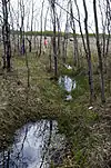 More images | |||
| St. Ambroise Dakota Entrenchment | , Portage la Prairie, MB | 50°08′N 98°02′W | 7304 | | |||
| Macdonald Pioneer Cemetery | , Portage la Prairie, MB | 50°03′48″N 98°28′09″W | 7754 | | |||
| St. Mary's la Prairie Anglican Church | 36 Second Street SW, Portage la Prairie, MB | 49°58′21″N 98°17′36″W | 4297 | | |||
| Portage la Prairie Dominion Post Office | 97 Saskatchewan Avenue, Portage la Prairie, MB | 49°58′21″N 98°17′11″W | 5485 | 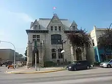 | |||
| Portage la Prairie Land Titles Building | 103 3rd Street NE, Portage la Prairie, MB | 49°58′27″N 98°17′06″W | 5848 | | |||
| Portage la Prairie Public Building National Historic Site of Canada | 55 Saskatchewan Avenue West, Portage la Prairie, MB | 49°58′22″N 98°17′30″W | 7543 | More images | |||
| McCowan House | 39 2nd Street SW, Portage la Prairie, MB | 49°58′11″N 98°17′36″W | 8848 | | |||
| First Homestead in Western Canada National Historic Site of Canada | Highway 240, 1 mile north of Hwy 249 junction, Portage la Prairie, MB | 50°03′45″N 98°17′08″W | 17541 | | |||
| Fort La Reine National Historic Site of Canada | 130 Yellowquill Trail, Portage la Prairie, MB | 49°57′04″N 98°19′38″W | 17947 | 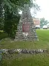 More images | |||
| Portage la Prairie Armoury | 143 Second Street, Portage la Prairie, MB | 49°58′34″N 98°17′35″W | 9512 | | |||
| Hill's Drug Store | 200 Saskatchewan Avenue East, Portage la Prairie, MB | 49°35′N 98°10′W | 16350 | | |||
| Saint-Claude Gaol Museum | 5 Provincial Road & 240 N., St. Claude, MB | 49°39′54″N 98°20′42″W | 6429 | | |||
| Treherne United Church | 186 Boyne Street, Treherne, MB | 49°37′41″N 98°41′50″W | 6735 | |
See also
| Wikimedia Commons has media related to Cultural heritage monuments in Manitoba. |
This article is issued from Wikipedia. The text is licensed under Creative Commons - Attribution - Sharealike. Additional terms may apply for the media files.