List of historic places in northern and central British Columbia Interior
The following list includes all of the Canadian Register of Historic Places listings in:
- Bulkley-Nechako Regional District,
- Cariboo Regional District,
- Fraser-Fort George Regional District,
- Peace River Country, and
- Stikine Country.
| Name | Address | Coordinates | IDF | IDP | IDM | Image | |
|---|---|---|---|---|---|---|---|
| Barkerville | , Cariboo Regional District, BC | 53°3′57″N 121°31′2″W | 14309 | 1749 | Q808269 |  More images | |
| Fish Cache | , Fort St. James, BC | 54°26′06″N 124°15′22″W | 2961 |  | |||
| General Warehouse | , Fort St. James, BC | 54°26′06″N 124°15′22″W | 2963 | | |||
| St. Andrew's Church | , Bennett Lake, BC | 59°46′09″N 135°07′05″W | 3653 |  More images | |||
| Men's House | , Fort St. James, BC | 54°26′06″N 124°15′25″W | 3665 | | |||
| Officer's Dwelling | , Fort St. James, BC | 54°26′06″N 124°15′25″W | 3666 | | |||
| Fort St. James National Historic Site of Canada | PO Box 1148, Fort St. James, BC | 54°26′07″N 124°15′25″W | 7617 |  | |||
| Chilkoot Trail National Historic Site of Canada | , Cassiar, BC | 59°46′02″N 135°06′36″W | 9087 |  More images | |||
| Federal Building | 10401 10th Street, Dawson Creek, Peace River Country, BC | 9522 | | ||||
| Chee Kung Tong Building National Historic Site of Canada | Box 19, Barkerville, BC | 53°04′00″N 121°31′01″W | 11971 | 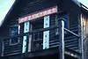 | |||
| Cottonwood House | 4660 Highway 26, Cottonwood, BC | 53°03′02″N 122°09′25″W | 15813 | 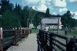 | |||
| Fort McLeod National Historic Site of Canada | Carp Lake Road, Fort McLeod Historic Park, McLeod Lake, BC | 54°59′00″N 123°03′00″W | 16523 |  | |||
| McLeod's Lake Post | Old Carp Lake Road, McLeod Lake, BC | 54°59′35″N 123°02′20″W | 16592 |  | |||
| Canadian National Railway Station | Main Street at Railway Avenue, Smithers, BC | 54°46′41″N 127°10′33″W | 6493 | | |||
| Canadian National Railway Station | First Avenue and Main Street, McBride, BC | 53°18′04″N 120°10′12″W | 6631 | | |||
| Fort Alexandria National Historic Site of Canada | , Alexandria, BC | 52°33′47″N 122°28′48″W | 17741 |  | |||
| 108 Mile Heritage Site | Highway 97, 108 Mile Ranch, BC | 51°45′00″N 121°20′53″W | 18409 |  | |||
| 150 Mile Little Red Schoolhouse | 3081 Old Schoolhouse Road, 150 Mile House, BC | 52°06′28″N 121°55′40″W | 18749 | | |||
| 150 Mile Courthouse | Highway 97, 150 Mile House, BC | 52°06′35″N 121°55′42″W | 19032 | | |||
| Knoll House | , Chilanko Forks, BC | 19031 | | ||||
| Telegraph Trail | Roughly, Highway 97 in the Cariboo Regional District, Cariboo Regional District, BC | 51°45′04″N 121°20′55″W | 20623 | | |||
| Blessing's Grave | Highway 26, 43 km east of Quesnel, Pinegrove, BC | 53°03′48″N 121°56′53″W | 21414 | | |||
| Potato House | 49 Borland Street, Williams Lake, BC | 52°07′47″N 122°08′46″W | 20622 | |
References
- (references appear in the table above as external links)
This article is issued from Wikipedia. The text is licensed under Creative Commons - Attribution - Sharealike. Additional terms may apply for the media files.