Loaita Island
Loaita Island 10°40′N 114°25′E -- also known as Kota Island (Tagalog: Pulo ng Kota, lit. 'Island of the Fort'); Mandarin Chinese: 南鑰島/南钥岛; pinyin: Nányào Dǎo, and Vietnamese: Đảo Loại Ta, with an area of 6.45 hectares (15.9 acres) -- is the tenth largest of the naturally-occurring Spratly Islands, and the fifth largest of the Philippine-occupied islands.[1] It is located just to the west of the northern part of Dangerous Ground, and is 22 miles (35 km) southeast of Philippine-occupied Thitu Island (Pag-asa) and 22 miles (35 km) north-northeast of Taiwan-occupied Itu Aba Island.[2]
| Disputed island Other names: Kota Island (Philippine English) Pulo ng Kota (Filipino) Đảo Loại Ta (Vietnamese) 南鑰島 / 南钥岛 Nányào Dǎo (Chinese) | |
|---|---|
 Loaita Island | |
| Geography | |
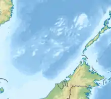 | |
| Location | South China Sea |
| Coordinates | 10°40′N 114°25′E |
| Archipelago | Spratly Islands |
| Administered by | |
| Philippines | |
| Municipality | Kalayaan, Palawan |
| Claimed by | |
| People's Republic of China | |
| Philippines | |
| Republic of China (Taiwan) | |
| Vietnam | |
The island is administered by the Philippines as part of Kalayaan, Palawan.
The island is also claimed by the People's Republic of China, the Republic of China (Taiwan) and Vietnam.
Environment
The island fringes the Loaita Bank, shoals and reefs.[3] Its calcarenite outcrop is visible along its western side at low tide. The present shape of the island indicates sand buildup along its eastern side. The anchor-shaped side will eventually connect with the northern portion as the sand buildup continues, thereby creating another mini-lagoon in the process. The presence of migrating sea birds adds to the high phosphorus content of the island's sand. Occasionally, giant sea turtles lay their eggs on the island. The island is covered with mangrove bushes, above which rise coconut palms and other small trees.
History
On 22 May 1963, a sovereignty stele was rebuilt on Loaita Island by crew members of the three vessels Huong Giang, Chi Lang and Ky Hoa of the South Vietnam.[4]
Several Philippine soldiers have been stationed on the island since 1968 when the Philippines occupied it. There are only a few structures, which serve as shelters for the soldiers.
The soldiers also guard the nearby Lankiam Cay (Panata) which lies about 8 miles (13 km) to the east-northeast. The cay is under observation from a tall structure on the island, and the Philippine soldiers also regularly visit it.
Loaita Nan and Loaita Cay (Melchora Aquino), which are distinct from Kota, lie 5 miles (8.0 km) northwest and 1.5 miles (2.4 km) east-northeast. These are unoccupied features, but are also largely controlled by the Philippines.
See also
- List of maritime features in the Spratly Islands
- Policies, activities and history of the Philippines in Spratly Islands
References
- PAO-MIN, CHANG (1990). "A New Scramble for the South China Sea Islands". Contemporary Southeast Asia. 12 (1): 20–39. ISSN 0129-797X.
- "Thitu Island". Asia Maritime Transparency Initiative. Retrieved 2021-01-17.
- Sailing Directions (Enroute), Pub. 161: South China Sea and the Gulf of Thailand (PDF). Sailing Directions. United States National Geospatial-Intelligence Agency. 2017. p. 13.
- ""White Paper on the Hoang Sa (Paracel) and Truong Sa (Spratly) Islands (1975)". Ministry of Foreign Affairs (Republic of Vietnam).
External links
- NGA Chart 93044 shows the area NW of Dangerous Ground
| Related articles | |||||||||||
|---|---|---|---|---|---|---|---|---|---|---|---|
| Confrontations | |||||||||||
| Regions | |||||||||||
| Occupied features | |||||||||||
| Unoccupied features | |||||||||||