Investigator Shoal
Investigator Shoal, also known as Malay: Terumbu Peninjau; Pawikan Shoal (Tagalog: Kulumpol ng Pawikan, lit. 'Cluster of Sea Turtle'); Vietnamese: bãi Thám Hiểm; Mandarin Chinese: 榆亚暗沙; pinyin: Yúyà ànshā, is located in the SW of Dangerous Ground in the Spratly Islands of the South China Sea.[1]
| Disputed island Other names: Terumbu Peninjau (Malay) Pawikan Shoal (Philippine English) Kulumpol ng Pawikan (Filipino) Bãi Thám Hiểm (Vietnamese) 榆亚暗沙 Yúyà ànshā (Chinese) | |
|---|---|
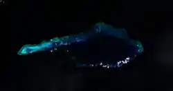 Satellite image of Investigator Shoal by NASA. | |
| Geography | |
 | |
| Location | South China Sea |
| Coordinates | 8°6′51″N 114°42′7″E |
| Archipelago | Spratly Islands |
| Administered by | |
| Malaysia | |
| Claimed by | |
| People's Republic of China | |
| City | Sansha, Hainan |
| Philippines | |
| Municipality | Kalayaan, Palawan |
| Republic of China (Taiwan) | |
| Municipality | Cijin, Kaohsiung |
| Vietnam | |
| District | Truong Sa, Khanh Hoa |
It is an atoll above water at low tide; some large rocks at the western end might be visible at high water. The atoll has a total length of 32.1 kilometres (19.9 mi) and is up to 10.6 km wide.[2] The total area of the atoll is 188 square kilometres (73 sq mi). The lagoon is up to 45 meters deep.[3]
It is one of the areas in the Spratly Islands occupied by Malaysia. The Royal Malaysian Navy has maintained an "offshore naval station" there called "Station Papa" since 1999.[4]
References
- NGA Chart 93047, oceangrafix.com
- Measured from a satellite image with the wikimapia measuring tool at Wikimapia
- Atoll Area, Depth and Rainfall, rock.geosociety.org
- Joshua Ho; Sam Bateman (15 February 2013). Maritime Challenges and Priorities in Asia: Implications for Regional Security. Routledge. pp. 74–. ISBN 978-1-136-29820-2.
| Related articles | |||||||||||
|---|---|---|---|---|---|---|---|---|---|---|---|
| Confrontations | |||||||||||
| Regions | |||||||||||
| Occupied features | |||||||||||
| Unoccupied features | |||||||||||
