Thitu Island
Thitu Island, also known as Pag-asa Island (Tagalog: Pulo ng Pag-asa, lit. 'island of hope'; Pangasinan: Ilalo; Hokkien Min Nan Chinese: 鐵峙/铁峙; Pe̍h-ōe-jī: Thih-tu; lit. 'Iron Shoal'; Mandarin Chinese: 中業島/中业岛; pinyin: Zhōngyè Dǎo; Vietnamese: Đảo Thị Tứ), having an area of 37.2 hectares (92 acres), is the second largest of the naturally occurring[3] Spratly Islands and the largest of the Philippine-administered islands. It lies about 480 kilometres (300 mi) west of Puerto Princesa. Its neighbours are the North Danger Reef to the north, Subi Reef to the west, and the Loaita and Tizard Banks to the south.
| Disputed island Other names: Pag-asa Island (Philippine English) Pulo ng Pagasa (Filipino/Tagalog) Ilalo (Pangasinense) 鐵峙 / 铁峙 Thih-tu (Hokkien Chinese) Đảo Thị Tứ (Vietnamese) 中業島 / 中业岛 Zhōngyè Dǎo (Mandarin Chinese) | |
|---|---|
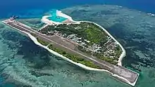 Pag-asa Island Aerial View | |
| Geography | |
 | |
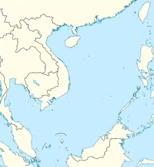
| Location | South China Sea/West Philippine Sea[lower-alpha 1] |
| Coordinates | 11°03′N 114°17′E |
| Archipelago | Spratly Islands |
| Administered by | |
| Philippines | |
| Municipality | Kalayaan, Palawan |
| Claimed by | |
| People's Republic of China | |
| Republic of China (Taiwan) | |
| Vietnam | |
| Demographics | |
| Population | 184 [1][2] |
As the administrative center of the Kalayaan municipality of Palawan province in the Philippines, it also administers nearly a dozen other islets, cays and reefs in the Spratly Islands.[4][5] The Permanent Court of Arbitration rejected China's claims on the South China Sea in 2016 and ruled in favour of the Philippines, which currently has the operational control over the island.[6] The United States and Australia have also rejected China's claim, citing that it is unlawful and baseless.[4] Vietnam also claims the island.
In 2019–20, the island's naval port and civilian-military airstrip were upgraded despite being swarmed by Chinese vessels.[4] Pag-asa Island has an naval jetty and landing ramp, dual use military and civilian airstrip, a 5-bed lying-in clinic, a communication tower powered by Smart, and a small elementary school.[7][8]
Etymology
The Filipino (Tagalog) name of the island is Pag-asa ("Hope"). It is also variously called in the following languages, English: Thitu Island; Mandarin simplified Chinese: 中业岛; traditional Chinese: 中業島; pinyin: Zhōngyè Dǎo; Vietnamese: Đảo Thị Tứ; Pangasinan: Ilalo; Hokkien Chinese: 鐵峙/铁峙; Pe̍h-ōe-jī: Thih-tu; lit. 'Iron Shoal'.[3]
Hokkien Chinese fishermen historically called the island Thih-tu (Chinese: 鐵峙/铁峙; Pe̍h-ōe-jī: Thih-tu; lit. 'Iron Shoal'; in Hokkien Min Nan pronounced IPA: [t'iɁtu]). It is sometimes incorrectly referred to as "Tiezhi Island" from the Mandarin reading (Chinese: 鐵峙島/铁峙岛; pinyin: Tiězhì Dǎo; lit. 'Iron Shoal Island'); Tiezhi Reef (铁峙礁; 鐵寺礁) refers to another area 7.5 km northeast of this island.[9] The modern Mandarin Chinese name of the island was taken from one of the battleships named Chung-yeh (中業號; Zhongye Hao), sent by the Chinese government during the Republic of China era to regain control of the island in 1946.[10][11]
History
Early and colonial history
There are historical records of the island having been inhabited, at various times in history, by fishermen from Champa in present-day Vietnam and the Chinese, and during the Second World War by French Indochina and Imperial Japanese troops.[12][13][14]
From 1930 to 1933, the French colonial government in French Indochina sent naval troops to the Spratlys, including Thitu Island. On 21 December 1933, Gouverneur M. J. Krautheimer in Cochinchina (now Vietnam) decided to annexe the Spratlys to Bà Rịa Province.[15]
Occupation and Establishment of civilian administration
On 22 May 1963, the Republic of Vietnam Navy a sovereignty stele on Thitu Island by crew members of the three vessels Huong Giang, Chi Lang and Ky Hoa of the South Vietnam.[16]
There were no large settlements on the island until 1956, when a Filipino lawyer-businessman-adventurer named Tomas Cloma decided to "claim" a part of the Spratly islands as his own, naming it the "Free Territory of Freedomland".[17]
On 18 April 1971, due to a strong typhoon hitting Thitu Island (Zhongye Island), the Republic of China (Taiwan) authorities ordered all the garrisons on Zhongye Island to withdraw to Taiping Island to avoid typhoons. However, after the typhoon, the Taiwan side changed its defence, transferred the original troops back to Taiwan, and then used the landing ship to transport new troops to Zhongye Island. The Philippines saw this empty space and organised the troops to land on the island occupied by Taiwan on 29 July and renamed the island "Pag-asa Island". According to the 155th page of the second episode of "The Land Salary" published by the Taiwan Marine Corps Command, the Taiwan Navy detachment that arrived at Zhongye Island on the same day found that the Philippine Marine Corps was on the island, and Captain Hao Deyun immediately ordered the command. The 76mm gun was ready to be fired. The Philippine army on the island is a huge threat to Taiwanese forces, as a result they suddenly received an order from above: no challenge, the troops changed to Taiping Island. These Taiwanese Kuomintang officers and men had to watch the Zhongye Island fall back into the hands of the Philippines.[18]
The Philippines formally established the Municipality of Kalayaan on Pag-asa island on 11 June 1978, by virtue of Presidential Decree 1596 series of 1978.[19]
Rejection of Chinese claim by Permanent Court of Arbitration
In January 2014, the Chinese media reported the ambitions of China to reclaim the island as its own.[20] After Permanent Court of Arbitration rejected China's claims on the South China Sea in 2016 and ruled in favour of Philippines, in August 2017 China sent a contingent of naval vessels to the immediate vicinity of Thitu Island, including two frigates, one Coast Guard vessel, and two large fishing vessels.[21] In March 2019, it was reported by Taiwan that 600 Chinese vessels had come and gone around the island in the first quarter of that year, with dozens of vessels maintaining their presence on a daily basis[22] Philippines has asked the China to respect the rule of law.,[6] in what has been called an example of China's Cabbage tactics by U.S.-based Asia Maritime Transparency Initiative.[23][24] Taiwan also claims the island, but its claims are subject to Permanent Court of Arbitration ruling in favour of Philippines.
Permanent Court of Arbitration which ruled against China stated that "there was no evidence it had historically exercised exclusive control over the sea's waters or resources". USA and Australia have also formally rejected China's territorial and maritime claims in the South China Sea since it had "no legal basis" and USA called China's actions in the area "unlawful".[25]
Post-PCA decision
Seven new buildings were constructed in Pag-asa Island in 2017.[26] Around 2018–19, Philippines started to built a beach ramp, enabling the delivery of construction equipment for to work on the construction, rehabilitation and repairs of the Rancudo Airfield airstrip, soldiers' barracks, conventional and renewable power generators, desalination facilities, lighthouses, sewage disposal system, shelters and storage facilities for civilian fishermen.[27]
By May 2020, the beaching ramp was completed and Filipino Naval ship BRP Ivatan landed on the ramp. Work on the port and upgrades to the island's airstrip progressed.[4]
On 9 June 2020, the Philippines' Department of National Defense (DND) led the inauguration of a beaching ramp on the Pag-asa island which was finally completed after three years. The facility enabled to bring in more materials and equipment to repair and maintain the airstrip and building of other facilities.[28] Also, Department of Transportation (DOTR) confirmed that the new seaport and sheltered port in the Pag-asa island is completed and ready to operate by 12 June.[29][30] In June 2020, Philippines reversed its decision to suspend Philippines–United States Visiting Forces Agreement, and completed construction of access ramp at the Thitu island which will enable Philippines to commence repair to the airbase runway. China has been asked by Philippines to respect the Permanent Court of Arbitration which rejected China's claims on the South China Seam asked China to follow the rule of law, and consequently post Corona virus the trust deficit between China and Philippines has increased.[6]
In August 2020, the Kalayaan municipal government named six sandbars and two reefs associated with Thitu Island.[31]
Topography
Pag-asa Island is low-lying, with trees, shrubs and sand bars. It is surrounded by coral reefs populated with rusting shipwrecks visible above water.[32]
Civilian administration
The island serves as the town proper to the municipality of Kalayaan. Only Pag-asa Island, among all Philippine-occupied Spratly islands, is currently inhabited by Filipino civilians. The civilian population of about 300, which includes children, were introduced in 2001.[33] However, fewer than 200 civilian Filipinos are present in the island at a time. They live in a few dozen houses, linked with sandy paths.[32] It administers nearly dozen other islets, cays, and reefs in the Spratly Islands.[4] It is the only Philippine-occupied island in the Spratlys to have a significant number of structures, including a municipal hall, multi-purpose hall, health center, school, water-filtration plant, engineering building, marina, communication tower, and military barracks.[34] The residents raise pigs, goats, and chickens, and plant crops in an allotted space to supplement their supplies of goods provided by a naval vessel which visits once a month. By day, the residents get electricity from a power generator owned by the municipality. By night, they shift to stored solar power that comes from 1.5-volt solar panels installed on the island. The houses do not have running water – water is used from tanks in front of each house.[32]
Military
The island has been occupied and administered by the Philippines since 1971.
Being the second largest of the Spratly Islands,[35] It is tightly protected by the Philippine forces. The island's beaches have unused concrete bunkers which were built in the 1970s, a few years after the Philippine military base was established.[32] Two-thirds of the Philippine military stationed in Philippine-occupied islands (i.e. 40 out of 60 soldiers) are assigned to the island.[36]
Rancudo Airfield
Rancudo Airfield | |||||||||||
|---|---|---|---|---|---|---|---|---|---|---|---|
| Summary | |||||||||||
| Airport type | Military | ||||||||||
| Operator | Philippine Air Force | ||||||||||
| Location | Pag-asa Island (Thitu Island) | ||||||||||
| Map | |||||||||||
 Rancudo Airfield | |||||||||||
| Runways | |||||||||||
| |||||||||||
Rancudo Airfield is a military and civilian airfield[37] which has a 1,300 metres (1,400 yd) unpaved airstrip. It currently operates on 1,200 airstrip because both ends of the runway have already eroded to the sea. Repairs are on-going and are expected to be finished by the end of 2021.[26]
Naval Station Emilio Liwanag
Naval Station Emilio Liwanag (formerly called as Naval Station Pag-Asa) is the naval base of the Philippine Navy within Pag-asa, Kalayaan, Palawan. It was renamed on 7 July 2009 in honour of Emilio S. Liwanag, a retired World War II and Korean War veteran. Philippine Navy's BRP Lanao del Norte (LT-504) to run aground during a failed attempt to dock near the island in 2004. The damaged ship remains at the site of the wreck. Additionally, the Philippine Navy has since then built a naval base be built on the island, specifically for the purposes of training the Philippine Navy's elite Special Warfare Group or Navy Seals.
Development plans
The Philippine Navy has since 1999 proposed to create a long causeway leading to a deep-water region.[37]
The island has a white sand coastline, is filled with trees, and is a sanctuary of several species of sea birds. Its wide coral base makes for good diving. Senator Sonny Angara filed a bill on 27 August 2016 that aims to promote the island as an ecotourism zone.[38]
In 2017, approximately 1.6 billion pesos was allocated to the island's development, for projects including a desalination plant, a port, and runway repairs.[39] Newly repaired naval and air ports will enable the delivery of construction materials and essential supplies to improve living conditions, and construction of desalination plant, renewable energy power source, cold storage facility, and fish port.[4]
See also
- Kalayaan, Palawan
- Territorial disputes in the South China Sea
- China containment policy
- Dongsha Island Airport (Pratas Island)
- Yongxing Island Airport (Woody Island in the Paracel Islands)
- List of airports in the Spratly Islands
- List of maritime features in the Spratly Islands
- Taiping Island Airport
- Layang-Layang Airport
Notes
- West Philippine Sea is the official designation by the Philippine government of the eastern parts of the South China Sea which are included in the Philippines' exclusive economic zone.
References
- Census of Population (2015). Highlights of the Philippine Population 2015 Census of Population. PSA. Retrieved 20 June 2016.
- "Philippine Population Density (Based on the 2015 Census of Population)". Philippine Statistics Authority. Retrieved 2 November 2017.
- Note that in 2014 the PRC embarked on a number of reclamation projects in the Spratly Islands. It appears that the largest of these, at Fiery Cross Reef, is of at least 60 hectares, and according to some unverifiable sources, possibly as large as 150 hectares. Kristine Kwok and Minnie Chan (8 June 2014). "China plans artificial island in disputed Spratlys chain in South China Sea". South China Morning Post. Retrieved 28 September 2014.
- Philippines bolsters posture in South China Sea after navy ship docks at new Spratly Islands port, South China Morning Post, 27 May 2020.
- "Countries Around South China Sea Bolster Claims With Island Outposts".
- Golden period of China-Philippines friendship loses its shine, South China Morning Post, 23 July 2020.
- Esmaquel II, Paterno (19 July 2014). "PH town 'no match' vs China's Sansha City". Rappler. Retrieved 21 March 2014.
- Angelina G. Goloy "Promise of Pag-asa", Manila Standard, Manila, 22 August 2005. Retrieved on 10 October 2005.
- Tong Wong (25 March 2009). "Who is the owner of the Spratly Islands?(Chinese)" (in Chinese). Archived from the original on 17 January 2016. Retrieved 18 July 2016.
- Lu, Yiran (吕一燃) (2007). 中国近代边界史 (A modern history of China's borders) (in Chinese). 四川人民出版社 (Sichuan People's Publishing). pp. 1092–1093. ISBN 978-7220073311.
- Palatino, Raymond. "The Spratlys and the Philippine claim" (in Chinese). Retrieved 26 June 2014.
- "Timeline". History of the Spratlys. www.spratlys.org. Archived from the original on 21 March 2014. Retrieved 21 March 2014.
- Chemillier-Gendreau, Monique (2000). Sovereignty Over the Paracel and Spratly Islands. Kluwer Law International. ISBN 9041113819.
- China Sea pilot, Volume 1 (8th ed.). Taunton: UKHO - United Kingdom Hydrographic Office. 2010.
- "MỘT SỐ TƯ LIỆU LỊCH SỬ, PHÁP LÝ VỀ CHỦ QUYỀN CỦA VIỆT NAM ĐỐI VỚI HAI QUẦN ĐẢO HOÀNG SA VÀ TRƯỜNG SA" (PDF) (in Vietnamese). Archived from the original (PDF) on 5 September 2011.
- ""White Paper on the Hoang Sa (Paracel) and Truong Sa (Spratly) Islands (1975)". Ministry of Foreign Affairs (Republic of Vietnam).
- "China and Philippines: The reasons why a battle for Zhongye (Pag-asa) Island seems unavoidable". China Daily Mail. 13 January 2014. Retrieved 21 March 2014.
- Li, Jiang. "Mr". www.qq.com. Nan Fang Zhou Muo. Retrieved 29 May 2019.
- "Presidential Decree 1596 s1978". Retrieved 5 April 2015.
- "Chinese troops to seize Zhongye Island back from the Philippines in 2014". China Daily Mail. 11 January 2014. Retrieved 21 March 2014.
- Santos, Eimor. "Carpio to gov't: Protest 'Chinese presence,' guard sand bar near Pag-asa Island". CNN Philippines. Retrieved 21 August 2017.
- Mangosing, Frances. "Analyst: China maritime militia near Pag-asa threatens PH sea, air access". Inquirer.net. Retrieved 20 April 2019.
- "Philippines Protests "Maritime Militia" Buildup Off Thitu Island". Maritime Executive. 4 January 2019. Retrieved 3 October 2020.
- Pascual Jr, Federico D. (11 April 2019). "China's swarming: 'Cabbage strategy'". Philstar.
- South China Sea dispute: Australia says Beijing's claims have no legal basis, BBC, 25 July 2020.
- Laude, Jaime (27 May 2018). "Philippines repairs Spratlys runway". PhilStar Global. Retrieved 31 July 2019.
- Cortez, Gillian M. (8 February 2019). "Repairs on Pag-asa Island to continue – DND". BusinessWorld. Retrieved 31 July 2019.
- Sadongdong, Martin. "PH inaugurates beaching ramp on Pagasa Island in West PH Sea". Manila Bulletin. Retrieved 10 June 2020.
- Acosta, Rene. "A 'Historic' Landing". Business Mirror. Retrieved 10 June 2020.
- Yumol, David Tristan. "Tugade confirms Pag-Asa Island seaport ready to open by June 12". CNN Philippines. Retrieved 10 June 2020.
- Cabrera, Romina (17 August 2020). "Kalayaan LGU names 6 sandbars, reefs in West Philippine Sea". The Philippine Star. Retrieved 19 August 2020.
- Campbell, Eric (20 May 2014). "Reef Madness". ABC News. Retrieved 23 May 2014.
- Glionna, John M. (26 July 2009), "Squatters in paradise say it's job from hell", Los Angeles Times, Retrieved 6 September 2010.
- Abaricia, Aimee (16 July 2005). "The Trip To Kalayaan". The Philippine Star. Manila: B–6. Archived from the original (JPEG) on 3 October 2011. Retrieved 16 February 2008.
- The largest of the Spratly Islands is the Taiwanese occupied Itu Aba (Tai Ping) Island (46 hectares).
Spratly Islands. Microsoft Encarta Online Encyclopedia 2008. Archived from the original on 1 November 2009. Retrieved 30 March 2012.
"回眸︰1946年國民政府收復南沙太平島始末" (in Chinese). Archived from the original on 10 November 2012. Retrieved 30 March 2012. - Thayer, Carl, "What If China Did Invade Pag-asa Island?", The Diplomat, 16 January 2014.
- Gupta, Vipin; Bernstein, Adam (May 1999). "Remote Monitoring in the South China Sea". Sandia National Laboratory. Archived from the original on 29 March 2008. Retrieved 16 February 2008. Cite journal requires
|journal=(help) - "Angara bill: Declare Pag-asa Island an ecotourism destination". Rappler. 27 August 2016. Retrieved 19 March 2016.
- Bautista, Ronn (21 April 2017). "In shadow of China's reef city, Philippines seeks upgrade for its island patriots". Reuters. Retrieved 29 August 2017.
| Related articles | |||||||||||
|---|---|---|---|---|---|---|---|---|---|---|---|
| Confrontations | |||||||||||
| Regions | |||||||||||
| Occupied features | |||||||||||
| Unoccupied features | |||||||||||
