Londonderry, New Hampshire
Londonderry is a town in western Rockingham County, New Hampshire, United States. The town sits between Manchester and Derry, the largest and fourth-largest communities in the state. The population was 24,129 at the 2010 census[1] and an estimated 26,490 in 2019.[2] Londonderry is known for its apple orchards[3] and is home to the headquarters of Stonyfield Farm and part of Manchester-Boston Regional Airport.
Londonderry, New Hampshire | |
|---|---|
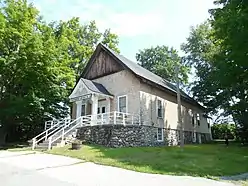
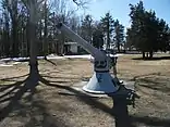
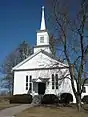
Clockwise, from top: Londonderry Grange #44, Londonderry United Methodist Church, Mack's Apples, gun on the town common | |
 Seal | |
 Location in Rockingham County and the state of New Hampshire | |
| Coordinates: 42°51′54″N 71°22′26″W | |
| Country | United States |
| State | New Hampshire |
| County | Rockingham |
| Incorporated | 1722 |
| Villages | Londonderry North Londonderry Wilson |
| Government | |
| • Town council | John Farrell, Chair Joe Green, Vice Chair Tom Dolan Jim Butler Deb Paul |
| • Town Manager | Kevin H. Smith |
| Area | |
| • Total | 42.1 sq mi (109.1 km2) |
| • Land | 42.0 sq mi (108.7 km2) |
| • Water | 0.1 sq mi (0.3 km2) 0.31% |
| Elevation | 420 ft (128 m) |
| Population (2010) | |
| • Total | 24,129 |
| • Density | 575/sq mi (221.9/km2) |
| Time zone | UTC-5 (Eastern) |
| • Summer (DST) | UTC-4 (Eastern) |
| ZIP codes | 03053 |
| Area code(s) | 603 |
| FIPS code | 33-43220 |
| GNIS feature ID | 0873651 |
| Website | www |
.jpg.webp)
The more densely settled portion of town, where 11,037 people lived at the 2010 census,[4] is defined as the Londonderry census-designated place (CDP) and roughly occupies the southeastern and southern parts of town, around New Hampshire Route 102.
History
Londonderry lies in an area that was first known as Nutfield because of the dense woods with nut trees. A petition for the town was submitted to the General Court of the Province of New Hampshire on September 23, 1719.[5] That petition stated that the petitioners had settled “at Nutfield about the Eleventh of Aprile last” – i.e. April 11, 1719. That petition requested “ten miles square” and stated that there were now about seventy families and inhabitants from both Ireland and New England. Many of the Scots-Irish settlers had left their homes in Londonderry in the Province of Ulster in the north of Ireland, and arrived in Boston in 1718 to start a new life without religious wars and persecution. On June 21, 1722, the town was chartered and given the name "Londonderry".[6][7][8] The grant made by Samuel Shute, Governor of the Province of New Hampshire, was for a tract of land described as follows:
"Beginning on the North East Angle at a Beach Tree marked which is the south East angle of Chester and Running from thence due South on Kingstown Line four miles and an half and from thence on a West Line one mile and three Quarters and from thence South six miles and an half and from thence West north West nine miles and an half, and from thence North Eleven miles and an half from thence north north East Three miles from thence East South East one mile and from thence South South West to the South West Angle of Chester and from thence on an East Line Bounding on Chester Ten miles unto the Beach Tree first mentioned.”
The town was divided into two parishes on February 25, 1739/40. Windham was set off and incorporated on February 12, 1741/42. The northwest portion, with other land, was incorporated as Derryfield, now Manchester, on September 3, 1751. Derry was incorporated on July 2, 1827. Border adjustments and annexations were made throughout this period continuing until June 27, 1857, when the line with Hudson (formerly known as Nottingham West) was established.
Approval of the petition submitted to the Province of New Hampshire required the petitioners to obtain an agreement from Col. John Wheelwright for the sale of the land. He held claim to it based on a grant to his grandfather. That agreement was obtained on October 12, 1719, and included a statement of the bounds, extending west as far as the Merrimack River.[9] This conflicted with a grant for the town of Dunstable, now Nashua, made by the Massachusetts Bay Colony in 1673.[10] The provincial line between Massachusetts and New Hampshire was not settled in its present location until 1741. Thus when Londonderry was granted, the westernmost portion actually lay within the Dunstable grant and the Province of Massachusetts Bay. The resulting land conflicts with "Dunstable encroachers" were still being dealt with by the town in 1783 and 1791.[11] Private owners were resolving these conflicts between each other as late as 1812.[12]
The Manchester and Lawrence Railroad was opened in November 1849,[13] with depots at North Londonderry, Wilson's Crossing, Derry and Windham. Two months later, on January 26, 1850, Dearborn Whittier, a prominent resident, was hit and killed by a railroad car at Wilson's Crossing.[14] On March 12 the town voted to require gates at all crossings, although the issue persisted for a few more years.[15]
The Manchester and Derry Street Railroad, sometimes referred to as the Derry and Manchester Street Railroad or trolley car, opened in December 1907 and operated between Broadway in Derry and Elm Street in Manchester until August 1926.[16]
In 1719, the first American potato was grown in Derry, then a part of Londonderry.[17]
The first U.S. census, conducted in 1790, reported the town's population to be 2,622.
Antique postcards
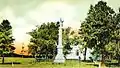 Civil War Soldiers' Monument c. 1905
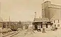 Railroad Station in 1914
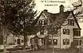 Col. W. S. Pillsbury residence c. 1910
Geography
Londonderry is the westernmost municipality in Rockingham County. It is bordered by the towns of Auburn to the northeast, Derry to the east, and Windham to the southeast, all in Rockingham County, and by Hudson to the south, Litchfield to the west, and Manchester to the north, in Hillsborough County. According to the United States Census Bureau, the town has a total area of 42.1 square miles (109.1 km2), of which 42.0 square miles (108.7 km2) is land and 0.1 square miles (0.3 km2) is water, comprising 0.31% of the town.[1]
The town of Londonderry is drained on the east and south by Beaver Brook and on the west by Little Cohas Brook, Watts Brook, Colby Brook and Nesenkeag Brook, all of which flow to the Merrimack River. The town's highest point is 535 feet (163 m) above sea level, on Number Eight Hill (named after the old school house that used to be on it) north of the center of town.
The town is crossed by Interstate 93, New Hampshire Route 102, New Hampshire Route 128, and New Hampshire Route 28. Half of Manchester–Boston Regional Airport, including the main terminal, is in the northwest corner of the town.
Though Londonderry has grown to become one of the larger towns, by population, in the state, it lacks any concentrated downtown area, central business district, or town center. Historically, no village had developed in Londonderry, as it was largely a rural farming area. Population growth in the town only began in the 1970s, when the construction of I-93 turned Londonderry into a bedroom community and exurb for the Greater Boston area. The major retail district lies in the town's southeastern corner near where NH 102 interchanges with I-93, with smaller commercial districts lying at the intersection of NH 128 and NH 102, and near where NH 28 and NH 128 merge. The Town Hall and schools are built near the geographic center of the town along an otherwise rural stretch of NH 128.
Adjacent municipalities
- Manchester, New Hampshire (north)
- Auburn, New Hampshire (northeast)
- Derry, New Hampshire (east)
- Windham, New Hampshire (southeast)
- Hudson, New Hampshire (south)
- Litchfield, New Hampshire (west)
Climate
Londonderry has a four-season humid continental climate (Köppen Dfa), with long, cold, snowy winters, and very warm and somewhat humid summers; spring and fall in between are crisp and relatively brief transitions. Precipitation is well-spread throughout the year, including snowfall in the winter.
Demographics
| Historical population | |||
|---|---|---|---|
| Census | Pop. | %± | |
| 1790 | 2,622 | — | |
| 1800 | 2,650 | 1.1% | |
| 1810 | 2,766 | 4.4% | |
| 1820 | 3,127 | 13.1% | |
| 1830 | 1,469 | −53.0% | |
| 1840 | 1,556 | 5.9% | |
| 1850 | 1,731 | 11.2% | |
| 1860 | 1,717 | −0.8% | |
| 1870 | 1,405 | −18.2% | |
| 1880 | 1,363 | −3.0% | |
| 1890 | 1,220 | −10.5% | |
| 1900 | 1,408 | 15.4% | |
| 1910 | 1,533 | 8.9% | |
| 1920 | 1,303 | −15.0% | |
| 1930 | 1,373 | 5.4% | |
| 1940 | 1,429 | 4.1% | |
| 1950 | 1,640 | 14.8% | |
| 1960 | 2,457 | 49.8% | |
| 1970 | 5,346 | 117.6% | |
| 1980 | 13,598 | 154.4% | |
| 1990 | 19,781 | 45.5% | |
| 2000 | 23,236 | 17.5% | |
| 2010 | 24,129 | 3.8% | |
| 2017 (est.) | 26,126 | [2] | 8.3% |
| U.S. Decennial Census[18] | |||
As of the census of 2010, there were 24,129 people, 8,438 households, and 6,678 families residing in the town. The population density was 574.5 people per square mile (221.9/km2). There were 8,771 housing units at an average density of 208.8 per square mile (80.7/km2). The racial makeup of the town was 95.8% White, 0.7% Black or African American, 0.1% Native American or Alaska Native, 1.7% Asian, 0.03% Pacific Islander, 0.4% some other race, and 1.2% from two or more races. Hispanic or Latino of any race were 2.1% of the population.[19]
There were 8,438 households, out of which 41.7% had children under the age of 18 living with them, 65.9% were headed by married couples living together, 9.2% had a female householder with no husband present, and 20.9% were non-families. 15.8% of all households were made up of individuals, and 5.1% were someone living alone who was 65 years of age or older. The average household size was 2.86, and the average family size was 3.21.[19]
In the town, the population was spread out, with 26.9% under the age of 18, 7.1% from 18 to 24, 23.6% from 25 to 44, 33.6% from 45 to 64, and 8.7% who were 65 years of age or older. The median age was 39.6 years. For every 100 females, there were 98.3 males. For every 100 females age 18 and over, there were 94.7 males.[19]
For the period 2009–13, the estimated median annual income for a household in the town was $90,263, and the median income for a family was $107,100. Male full-time workers had a median income of $71,280 versus $50,081 for females. The per capita income for the town was $38,553. About 1.6% of families and 2.8% of the population were below the poverty line, including 2.6% of those under age 18 and 4.7% of those age 65 or over.[20]
Economy
Londonderry is home to numerous businesses, many of which are located in the northern part of the town near Manchester-Boston Regional Airport (MHT), or in the southeastern part of town near I-93, on NH 102. Major businesses headquartered in town include Stonyfield Farm and Blue Seal Feeds; a bottling facility of the Coca-Cola Bottling Co. is also located in town. The town is also home to numerous chain retailers.
Mack's Apples, Sunnycrest Farm, and Elwood Orchards are among the several orchards in town and are emblematic of the town's important farming heritage. The abundance of apple orchards in town has made apple picking a popular fall activity among all residents.
One former apple orchard is currently being transformed into a 600-acre commercial and residential development to be known as Woodmont Commons.[3]
Transportation
Londonderry is crossed by three New Hampshire state highways and one Interstate Highway.
- NH 28 crosses North Londonderry, entering the town from Derry in the east and leaving the town into Manchester in the north. NH 28 is known locally as Rockingham Road when it enters from Derry, and merges with Mammoth Road at the northern terminus of NH 128.
- NH 102 crosses South Londonderry, entering the town from Hudson in the southwest corner, and leaving the town into Derry in the east. NH 102 is known locally as Nashua Road.
- NH 128 is the main north–south route through Londonderry, entering from Windham in the south and terminating at NH 28 in North Londonderry. It is known locally as Mammoth Road.
- Interstate 93 crosses the eastern side of Londonderry from south to north. There are two exits to access Londonderry: Exit 4 (NH 102) and Exit 5 (NH 28).
Londonderry is partially home to the Manchester–Boston Regional Airport which it shares with the city of Manchester. There is no passenger rail service in Londonderry.
Government and politics
Londonderry is part of New Hampshire's 1st congressional district, currently represented by Democrat Chris Pappas. Londonderry is part of the Executive Council of New Hampshire's 4th district, currently represented by Republican Ted Gatsas. The town is part of New Hampshire's 14h State Senate district, currently represented by Republican Sharon Carson.
Londonderry has leaned considerably towards Republican in all elections, but the town has become more competitive in recent years. In 2020, Donald Trump received 49.8% of the vote, and Joe Biden received 48.7% of the vote.
Education
The town is served by the Londonderry School District.
Kindergarten:
- Moose Hill School (includes LEEP, the Londonderry Early Education Program)
Elementary schools:
- North School
- Matthew Thornton Elementary School
- South School
Middle school:
- Londonderry Middle School
High school:
- Londonderry High School (home of the Lancers), whose marching band program traveled to China in the summer of 2008 to participate in ceremonies for the Olympic Games. They also participated in the 2008 and 2012 Presidential Inaugural Parades.
Private schools:
- Victory Baptist School (K-12)
- Adventures in Learning
- Applewood Learning Center
- Cozy Kid's Child Care
- Kindercare
- Pixie Preschool I
Notable people
- Ant, host of VH1 reality series Celebrity Fit Club
- Al Baldasaro, Republican member of the New Hampshire House of Representatives,[21] advisor to President Trump[22]
- John Bell, 18th governor of New Hampshire[23]
- Samuel Bell, 14th governor of New Hampshire[24]
- Silas Betton, US congressman[25]
- Dominic DiMaggio, outfielder with the Boston Red Sox
- John Fisher, industrialist; US congressman from New York[26]
- Ryan Griffin, tight end for the New York Jets of the National Football League
- Kevin Hunt, NFL player (offensive lineman) for Green Bay Packers, New England Patriots, Houston Oilers, and New Orleans Saints[27]
- Arthur Livermore, US congressman[28]
- Joseph McKeen, president of Bowdoin College[29]
- Dan Mullen, head coach for the Mississippi State Bulldogs football team
- Ocean Born Mary, subject of a local ghost legend[30]
- William M. Oliver, US congressman[31]
- Ethan Paquin, poet[32]
- George W. Patterson, US congressman[33]
- Peter Patterson, businessman and Canadian politician
- William Patterson, US congressman[34]
- George Reid, Revolutionary War era officer[35]
- Laura Silva, 2007 Miss New Hampshire USA[36]
- William Stark, Revolutionary War era officer[37]
- Samuel Taggart, US congressman[38]
- Matthew Thornton, signer of the Declaration of Independence;[39] he lived in a part of the town that is now in Derry
- Brian Wilson, pitcher with the Los Angeles Dodgers and San Francisco Giants[40]
- James Wilson, first maker of globes in the US[41]
References
- "Geographic Identifiers: 2010 Census Summary File 1 (G001): Londonderry town, Rockingham County, New Hampshire". U.S. Census Bureau, American Factfinder. Archived from the original on April 16, 2015. Retrieved April 16, 2015.
- "Annual Estimates of the Resident Population: April 1, 2010 to July 1, 2017 (PEPANNRES): Minor Civil Divisions – New Hampshire". Archived from the original on February 13, 2020. Retrieved November 15, 2018.
- Bookman, Todd (January 23, 2018). "Can You Build A Downtown From Scratch? Londonderry, N.H. Is Going To Find Out". NHPR. Retrieved 7 November 2018.
- "Geographic Identifiers: 2010 Census Summary File 1 (G001): Londonderry CDP, New Hampshire". U.S. Census Bureau, American Factfinder. Archived from the original on April 16, 2015. Retrieved April 16, 2015.
- "Early Records of Londonderry, Windham and Derry, N.H." by George Waldo Browne, Vol. 1, Appendix, p. 377
- "Town Charters Granted Within the Present Limits of New Hampshire Vol. XXV" edited by Albert Stillman Batchellor, p. 272 et seq.
- "The Early History of Londonderry". Londonderry Historical Society. Archived from the original on August 4, 2012. Retrieved March 22, 2010.
- "The History of Londonderry" by Rev Edward L. Parker, p.60
- "Early Records of Londonderry, Windham and Derry, N.H." by George Waldo Browne, Vol. 1, p. 19.
- "Town Charters Including Grants of Territory Within the Present Limits of New Hampshire Vol. XXIV" edited by Albert Stillman Batchellor, p. 83 et seq.
- "Londonderry Town Records". pp. Vol. 2 img. 45, pp. 82, 83. Retrieved 4 December 2018.
Town Meeting May 29th, 1783: Voted to Profsicute Dunstable Encroachers. Notice of Town Meeting October 4th, 1791: 4ly To see what the Proprietors will do with a Number that wants their fourth Division's by being Encroached on by Dunstable Proprietors.
- "Rockingham County Registry of Deeds". pp. Lib. 196 Fol. 341. Retrieved 2 December 2018.
a certain tract of land situate in sd. Londonderry, containing about sixty nine acres, more or less, so far as the same lays within the claim of the sd. Caleb & John by virtue of a Deed to them from Anna Parker & Daniel Abbot Executors of the Estate of Robert Parker Esq. Deceased – being the same land which I purchased of one Joseph Copp
- "Report of Select Committee to Investigate the Affairs of the Manchester and Lawrence Railroad, June 1849". p. 8. Retrieved 4 December 2018.
… the road is making good progress towards completion – that it will probably be put in running order as early as October next …
- "Willey's Book of Nutfield" compiled and edited by George F. Willey, p. 70
- "Londonderry Town Records". pp. Vol. 5 img. 233, pp. 461 et seq. Retrieved 4 December 2018.
Town Meeting March 12th, 1850: 15th Voted that the Selectmen be instructed to see the Directors of the Manchester and Lawrence Railroad and have the crofsings of highways in said town made secure against any damages liable to occur against the public travellor himself or property.
- The Road to Derry: A Brief History by Richard Holmes, Chapter 6
- Wilkinson Rojo, Heather. "Derry, NH's Famous Potato". Nutfield Genealogy. Retrieved 2 December 2018.
- "Census of Population and Housing". Census.gov. Retrieved June 4, 2016.
- "Profile of General Population and Housing Characteristics: 2010 Census Summary File 1 (DP-1): Londonderry town, Rockingham County, New Hampshire". U.S. Census Bureau, American Factfinder. Archived from the original on April 16, 2015. Retrieved April 16, 2015.
- "Selected Economic Characteristics: 2009-2013 American Community Survey 5-Year Estimates (DP03): Londonderry town, Rockingham County, New Hampshire". U.S. Census Bureau, American Factfinder. Archived from the original on April 16, 2015. Retrieved April 16, 2015.
- "member". www.gencourt.state.nh.us. Archived from the original on 2009-11-02. Retrieved 2017-03-08.
- Gershon, Livia (2016-02-16). "Trump's biggest fan: a veteran and vote-wrangler – despite his own controversies". The Guardian. ISSN 0261-3077. Retrieved 2017-03-08.
- Porter, Joseph W. (1895). The Maine Historical Magazine, Volume 9. Joseph W. Porter. p. 41.
- "BELL, Samuel, (1770 - 1850)". Biographical Directory of the United States Congress. Retrieved January 14, 2014.
- "Alice Blaski". Biographical Directory of the United States Congress. Retrieved January 14, 2014.
- "FISHER, John, (1806 - 1882)". Biographical Directory of the United States Congress. Retrieved January 14, 2014.
- "Perseverance: Hunt Family Trait". The Courant. Retrieved January 14, 2014.
- "LIVERMORE, Arthur, (1766 - 1853)". Biographical Directory of the United States Congress. Retrieved January 14, 2014.
- "Joseph McKeen". Bowdoin College. Retrieved January 14, 2014.
- "Ocean Born Mary Legend". NHTourGuide.com. Retrieved January 14, 2014.
- "OLIVER, William Morrison, (1792 - 1863)". Biographical Directory of the United States Congress. Retrieved January 14, 2014.
- "EEthan Paquin, English". UMass Lowell. Archived from the original on January 16, 2014. Retrieved January 14, 2014.
- "PATTERSON, George Washington, (1799 - 1879)". Biographical Directory of the United States Congress. Retrieved January 14, 2014.
- "PATTERSON, William, (1789 - 1838)". Biographical Directory of the United States Congress. Retrieved March 12, 2014.
- Daughters of the American Revolution (1914). Lineage Book - National Society of the Daughters of the American Revolution, Volume 39. Daughters of the American Revolution. p. 318.
- Beale, Stephen (2006-09-17). "Londonderry teen crowned Miss New Hampshire USA". Union Leader. Archived from the original on 26 September 2007. Retrieved 2006-09-19.
- Parker, Edward Lutwyche (1851). The History of Londonderry, Comprising the Towns of Derry and Londonderry, N. H. Perkins and Whipple. p. 96.
- "TAGGART, Samuel, (1754 - 1825)". Biographical Directory of the United States Congress. Retrieved January 14, 2014.
- Reynolds, Alistair, "Matthew Thornton" Archived 2013-10-23 at the Wayback Machine, Maine Ulsterscots Project, retrieved Oct. 8, 2014
- "Brian Wilson Stats". Baseball Almanac. Retrieved January 14, 2014.
- White, James Terry (1921). The National Cyclopaedia of American Biograph. J.T. White. p. 102.
Further reading
External links
| Wikimedia Commons has media related to Londonderry, New Hampshire. |
- Town of Londonderry official website
- Londonderry Times, local newspaper
Places adjacent to Londonderry, New Hampshire | ||||||||||
|---|---|---|---|---|---|---|---|---|---|---|
| ||||||||||
Municipalities and communities of Rockingham County, New Hampshire, United States | ||
|---|---|---|
| City | 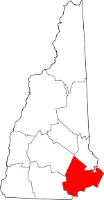 Map of New Hampshire highlighting Rockingham County | |
| Towns |
| |
| CDPs | ||
| Other villages | ||
| ||
| Authority control |
|---|