Lorraine, Quebec
Lorraine is an affluent off-island suburb of Montreal, in southwestern Quebec, Canada on the north shore of the Rivière des Mille-Îles in the Thérèse-De Blainville Regional County Municipality. There are no industries and only a very limited commercial district (comprising one medical center, one shopping mall, a golf course, a gym, a supermarket and arena); almost all houses are of the detached type. Furthermore, a large portion of the town territory is set aside as wild forest (Forêt du Grand Côteau); some bike/ski trails run through it. The town is divided into two areas, Uptown and Downtown (or Lorraine en haut and Lorraine en bas, colloquially, because the northern area is on higher ground). These two areas are also delimited by Quebec freeway A-640, and are only joined together by the main street (Boulevard de Gaulle) overpass.
Lorraine | |
|---|---|
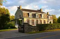 Garth House. | |
 Coat of arms | |
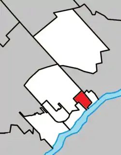 Location within Thérèse-De Blainville RCM. | |
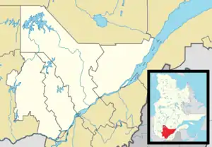 Lorraine Location in central Quebec. | |
| Coordinates: 45°41′N 73°47′W[1] | |
| Country | |
| Province | |
| Region | Laurentides |
| RCM | Thérèse-De Blainville |
| Constituted | February 4, 1960 |
| Government | |
| • Type | Lorraine City Council |
| • Mayor | Jean Comtois |
| • Federal riding | Thérèse-De Blainville |
| • Prov. riding | Blainville |
| Area | |
| • Total | 6.02 km2 (2.32 sq mi) |
| • Land | 5.89 km2 (2.27 sq mi) |
| There is an apparent contradiction between two authoritative sources | |
| Population (2016) | |
| • Total | 9,352 |
| • Density | 1,570.0/km2 (4,066/sq mi) |
| • Pop 2006–2011 | |
| Time zone | UTC−5 (EST) |
| • Summer (DST) | UTC−4 (EDT) |
| Postal code(s) | J6Z |
| Area code(s) | Area codes 450 |
| Highways | |
| Website | www |
Lorraine has earned a reputation for high-end homes with pristine lawns. Due to the heat and humidity of summers in the region, many of these properties have in ground swimming pools in backyards. The town prides itself with completely underground utility networks apart from a small older section of the town (Avenue Fraser, Mey and Bruyeres in particular). The absence of telephone and electric poles contributes to the aesthetic appeal of the municipality.
The town was founded February 4, 1960 and is named for the French region of the same name.
The town is the territory of the Roman Catholic parishal community of Charles-de-Foucault (old parish), part of the (new) Saint-Luc parish of the Terrebonne pastoral region of the Saint-Jérôme diocese. The town is now part of the Thérèse-De Blainville federal electoral district (Marc-Aurèle-Fortin federal electoral district) and Blainville provincial electoral district. It makes district 22 of the Seigneurie-des-Milles-Îles French school board and is part of district 8 of the Sir-Wilfrid-Laurier English school board. Lorraine is also a member of the Montreal Metropolitan Community.
The town has three elementary schools: École Le Carrefour and École Le Tournesol, which are very close to each other but separated by Parc Lorraine, as well as École du Ruisselet.
Education
The Commission scolaire de la Seigneurie-des-Mille-Îles (CSSMI) operates Francophone public schools.[4]
Francophone primary schools:
- École Le Carrefour
- École Le Tournesol
- École du Ruisselet
Zoned secondary schools include: École secondaire de Harfang in Sainte-Anne-des-Plaines; and École secondaire Hubert-Maisonneuve in Rosemère (for lower secondary) and École secondaire Rive-Nord in Bois-des-Filion.[5]
Sir Wilfrid Laurier School Board operates Anglophone public schools:
- McCaig Elementary School in Rosemère.[6]
- Rosemere High School in Rosemere.[7]
Activities
Activities for children
Municipal swimming pool, tennis court, soccer fields and basketball as well as the many parks of Lorraine will be able to fill the small and bigger. The Recreation and Cultural Services Department offers a variety of activities and events dedicated to children.[8]
Activities for adults
Volunteering, library program, lectures on various topics, exhibitions, competitions, mobile library and many other activities are available in the city.[9]
Climate
The climate of this city is a humid continental climate. Winters are cold with a lot of snowfall and summers are hot and humid. There are 4 seasons spring, summer, autumn and winter.
Demographics
| Canada Census Mother Tongue - Lorraine, Quebec[10] | ||||||||||||||||||
|---|---|---|---|---|---|---|---|---|---|---|---|---|---|---|---|---|---|---|
| Census | Total | French |
English |
French & English |
Other | |||||||||||||
| Year | Responses | Count | Trend | Pop % | Count | Trend | Pop % | Count | Trend | Pop % | Count | Trend | Pop % | |||||
2016 |
9,350 |
7,700 | 82.35% | 680 | 7.2% | 125 | 1.34% | 765 | 8.18% | |||||||||
2011 |
9,480 |
7970 | 84.07% | 640 | 6.7% | 135 | 1.4% | 640 | 6.75% | |||||||||
2006 |
9,613 |
8170 | 85.01% | 695 | 7.23% | 170 | 1.7% | 575 | 5.8% | |||||||||
2001 |
9,476 |
8165 | 86.12% | 755 | 7.9% | 75 | 0.8% | 480 | 5.1% | |||||||||
1996 |
8,875 |
7630 | n/a | 85.97% | 825 | n/a | 9.29% | 50 | n/a | 0.5% | 350 | n/a | 3.94% | |||||
Awards
In 2007 the town of Lorraine was recognized by the Canadian Society of Landscape Architects under the Awards of Excellence Program for 'La Promenade Riveraine Du Domaine Garth' project.
Facts
According to the Canada 2006 Census:
- Population: 9352
- Population growth (2011-2016) - 1,3 %
- Area: 6.04 km².
According to the Regions and Municipal Affairs Ministry of Quebec (as of 2017):
- Population: 9589
- Area: 6.02 km².
luausteat
References
- Reference number 36916 of the Commission de toponymie du Québec (in French)
- Geographic code 73025 in the official Répertoire des municipalités (in French)
- Statistics Canada 2011 Census – Lorraine census profile
- "Admission et inscription Archived 2015-01-31 at the Wayback Machine." Commission scolaire de la Seigneurie-des-Mille-Iles. Retrieved on December 7, 2014. "La Commission scolaire de la Seigneurie-des-Mille-Iles (CSSMI) offre ses services aux résidents des municipalités de : Blainville, Boisbriand, Bois-des-Filion, Deux-Montagnes, Lorraine, Mirabel (Saint-Augustin, Saint-Benoît, Sainte-Scholastique et secteur du Domaine-Vert), Oka, Pointe-Calumet, Rosemère, Sainte-Anne-des-Plaines, Sainte-Marthe-sur-le-Lac, Sainte-Thérèse, Saint-Eustache, Saint-Joseph-du-Lac, Saint-Placide et Terrebonne Ouest."
- "Répertoire des aires de desserte par ville 2017 - 2018 (Généré le 20/9/2017) Lorraine Archived 2017-09-20 at the Wayback Machine." Commission scolaire de la Seigneurie-des-Mille-Îles. Retrieved on September 20, 2017.
- "McCAIG ELEMENTARY ZONE." Sir Wilfrid Laurier School Board. Retrieved on September 16, 2017.
- "Rosemere High School Zone." Sir Wilfrid Laurier School Board. Retrieved on December 8, 2014.
- "Ville Lorraine - Activités pour enfants". Ville de Lorraine (in French). Retrieved 2019-08-08.
- "Ville Lorraine - Activités pour adultes". Ville de Lorraine (in French). Retrieved 2019-08-08.
- Statistics Canada: 1996, 2001, 2006, 2011, 2016 census
External links
See also
Places adjacent to Lorraine, Quebec | |
|---|---|
| Cities | |
|---|---|
| |
| Authority control |
|---|