Oka, Quebec
Oka is a small village on the northern bank of the Ottawa River (Rivière des Outaouais in French), northwest of Montreal, Quebec, Canada. Located in the Lower Laurentians on Lake of Two Mountains, where the Ottawa has its confluence with the St. Lawrence River, the town has a main thoroughfare that is now part of Quebec Route 344. It's located 50 km (30 miles) northwest of Montreal.
Oka | |
|---|---|
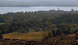 Oka village and Lake of Two Mountains as seen from Mount Oka | |
 Location within Deux-Montagnes RCM | |
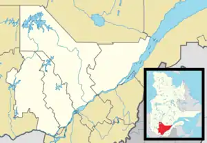 Oka Location in central Quebec | |
| Coordinates: 45°28′N 74°05′W[1] | |
| Country | |
| Province | |
| Region | Laurentides |
| RCM | Deux-Montagnes |
| Settled | 1721 |
| Constituted | September 8, 1999 |
| Government | |
| • Mayor | Pascal Quevillon |
| • Federal riding | Mirabel |
| • Prov. riding | Mirabel |
| Area | |
| • Total | 85.90 km2 (33.17 sq mi) |
| • Land | 57.30 km2 (22.12 sq mi) |
| Population (2011)[3] | |
| • Total | 3,969 |
| • Density | 69.3/km2 (179/sq mi) |
| • Pop 2006-2011 | |
| • Dwellings | 1,633 |
| Time zone | UTC−5 (EST) |
| • Summer (DST) | UTC−4 (EDT) |
| Postal code(s) | J0N 1E0 |
| Area code(s) | 450 and 579 |
| Highways | |
| Website | www |
This area was colonized by French settlers as a mission to First Nations in 1721 by brothers of the Sulpician Order branch of the Roman Catholic Church. Traditional owners are Mohawk (Kanienkaha), Algonquin, and Nipissing, who had a village known as Kanesatake, now a reserve within the boundaries of Oka.
History
17th and 18th centuries
Oka is historically connected to the first Amerindian mission established by the Sulpicians in Montreal. It was in 1718, moreover, that the Sulpicians obtained from the King of France the concession of the seigneury of Deux-Montagnes which corresponded to the present territories of the parishes of Oka, Saint-Placide, Saint-Benoît, Saint-Joseph The lake and the surrounding area.[4]
Original influx of inhabitants
The mission of La Montagne was transferred in 1696 to Sault-au-Récollet in Montreal and from there to Lac des Deux-Montagnes in 1721. This last movement was facilitated by the fact that in 1717 the Seigneurie du Lac Of the Deux-Montagnes was conceded to the Sulpicians by the King of France on the express condition of transferring the Indian mission there. Final concession was given in 1718 after the transfer of the mission proper. In 1720 Catholic Iroquois who were previously at the Sault au Récollet mission were moved to the new location.[5] In 1721, under the direction of Quere de Tréguron, Sulpician, a group of Algonquins and Iroquois emigrated on the shores of Lake Deux-Montagnes.[4]
By 1722 the transfer was almost completed. The proposed site was advantageous for the conversion of the Indians and for their defense and that of the colony. To prepare their installation, another Sulpician, Mr. Gay (who was the superior), made some clearing and build various buildings including a chapel, the missionary's house, a school intended for the Sisters of the Congregation Notre-Dame as well as cabins for the Indians. The Indian population increased considerably around 1727 when the Nipissingues and the Algonquins of the Île-aux-Tourtes mission also came to the Lake with their missionary Pierre-Élie Déperet.[4]
Building of Oratories
It is impossible to speak of the Lordship of the Lake without recalling that between 1740 and 1742, there was the setting up of the seven oratories that constitute the famous Calvary of Oka, work of the Sulpicians. Francois dit Belleville (who arrived in Nouvelle-France in 1754) was the author of the bas-reliefs of the chapels of this pilgrimage site, which is the oldest in America. The missionary Louis-Urgel Lafontaine (1895-1930) was the last to preach in Iroquois [language] at the location. The Calvary was built by the Indians and only for them in order to evangelize them.[4]
19th and 20th centuries
In the 19th century, as a result of the conquest of 1760, there was unrest among the various communities. The Mohawks allied with the British and turned against the French while the Algonquins had taken the side of the French.
The church, the presbytery and the outbuildings of Oka were set on fire on 15 June 1877.[4][6]
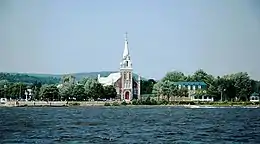
The present church was built between 1878 and 1883 according to the plans of the architects Perrault and Mesnard.[4]
Oka crisis
In 1990, the small community gained international attention in what became known as the Oka Crisis. It had approved development of a private golf course, to add nine holes and nearby luxury housing, which would have gone over the ancestral cemetary. The Mohawks of Kanesatake opposed this.
Several years before the crisis the Mohawks had initiated and lost a land claim court case in which they tried to gain control of what they termed "historic land". Land known from the early mission settlement as the "pine forest". The claim was rejected by the Provincial courts.
Much of the anger over this court loss and other non Oka related issues, as witnessed by the congregation of other tribes which had unresolved land claim issues resulting from the British conquests was unleashed during the crisis.
The Mohawks of Kanesatake barricaded a dirt road leading to the land, as well as the 344 which was the point of access to the reserve. During the 78-day confrontation, the Quebec Police Force (SQ) (and later Canadian Army units) confronted members of the Mohawk nation of the adjacent community of Kanesatake. The latter were joined by other Mohawk, First Nations, and Native American tribes. In addition, for several weeks, Mohawks at Kahnawake blockaded the approach to the Mercier Bridge, a route that ran through their land. Negotiations finally led to the Mohawks re-opening the road, after a few days. An SQ officer, Corporal Lemay, was shot and killed at a period of heightened tensions by his collegues, whom had openned fire on the Mohawks blocking the way to the cemetary, to prevent its destruction. The police shot to kill, while the Mohawks shot above everyone's heads, as proven by the bullets holes in the trees. The SQ said that the Mohawks had killed Corporal Lemay, but the trees are proof that it was not so. Numerous people were arrested. The disputed area was acquired by the Canadian Federal Government to appease the developers. Development was stopped.
A radio-conspirationnist reported on the situations daily, and only aggravated the tensions. As a result, many non-natives wished for the Natives to all be arrested and 'put back in their place'. Some more violent ones wished for them to be put down like dogs. Mohawks getting out of the reserve for work or grocery shopping were arrested, leaving the children to fend for themselves in the cars as their parents were taken away. All were humiliated, though it was mostly women, whom were often ordered and forced to disrobe themselves to their underwears for the sick appreciation of the police officers and to humiliate them thoroughly.
When the news of the Army coming reached the Mohawks, they immediately sent the eldery, the children, the ill, and the injuried away for their safety. Non-natives linning the roads shot everyhing they had, mostly rocks, at the cars, injuring the drivers, whom could not hide, as well as the passengers, whom had huddled themselves as low as possible to avoid injury. The cars were destroyed, the windows exploded, which still injured the occupants.
Some in the media reported the Mohawk's opposition to be based on the expansion of the golf course over what the Mohawks considered sacred land. This however was not the only premise of contention. Part of the dispute laid over persistent claims dating back to land right issues between the Sulpicians and Mohawks that related not to burial grounds or cemeteries, but to what was known as the "pine forest" and that commenced at the onset of the British conquests, the Mohawks allegiance to them and the definite change of attitude of the Mohawks towards the French.[6]
The Oka crisis garnered a great deal of media attention, and brought forth dozens of articles and books, never mentionning governemental actions that said governement found would 'ternish their image'. The death of Corporal Lemay remains 'unsolved' however, and the ongoing land claims to the pine forest have all, as of January 16, 2017, been dismissed in Federal courts. Despite promises to the contrary much of the disputed land obtained by the Federal Government remains unceded to traditional owners.
Demographics
.jpg.webp)
Population trend:[7]
- Population in 2011: 3,969 (2006 to 2011 population change: 20.3%)
- Population in 2006: 3,300
- Population in 2001: 3,194
- Population in 1996:
- Oka (municipality): 1 514
- Oka (parish): 1,498
- Population in 1991:
- Oka (municipality): 1,658
- Oka (parish): 1,656
Private dwellings occupied by usual residents: 1,546 (total dwellings: 1,633)
Mother tongue:
- French as first language: 92.3%
- English as first language: 4%
- English and French as first language: 1.2%
- Other as first language: 2.5%
Transportation
Highway 344 passes through Oka. The Oka Express goes to the Deux-Montagnes station and Terminus Saint-Eustache
Attractions
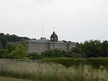
In the summertime, the community's long stretch of beachfront along the Ottawa River and the Lake of Two Mountains, and its marina draw people to the area from Montreal and neighboring cities. Another attraction is the Abbey of Notre-Dame du Lac, famous for its Oka cheese produced by Trappists monks there.
A small ferry service operates between Oka and the town of Hudson across the Ottawa River. During the winter months, a toll ice bridge provides access on this route.[8] There is also connection with the AMT Deux-Montagnes Train to and from Montreal's Central Station and Deux-Montagnes Station by the Oka Express minibus.[9]
Education
The Commission scolaire de la Seigneurie-des-Mille-Îles (CSSMI) operates French language public schools.[10]
Schools include:
- École secondaire d'Oka[11]
- École des Pins[12]
Some portions are instead zoned to École de l'Amitié in Saint-Placide.[13]
The Sir Wilfrid Laurier School Board (SWLSB) operates Anglophone public schools. Mountainview Elementary School and Saint Jude Elementary School, both in Deux-Montagnes, serve this community.[14][15] Lake of Two Mountains High School in Deux-Montagnes is the zoned high school.[16]
Climate
| Climate data for Oka | |||||||||||||
|---|---|---|---|---|---|---|---|---|---|---|---|---|---|
| Month | Jan | Feb | Mar | Apr | May | Jun | Jul | Aug | Sep | Oct | Nov | Dec | Year |
| Record high °C (°F) | 13 (55) |
14 (57) |
25.6 (78.1) |
30 (86) |
32.8 (91.0) |
35 (95) |
36.1 (97.0) |
35.6 (96.1) |
32.5 (90.5) |
27.8 (82.0) |
23.9 (75.0) |
16.5 (61.7) |
36.1 (97.0) |
| Average high °C (°F) | −6.4 (20.5) |
−4.2 (24.4) |
1.6 (34.9) |
10.3 (50.5) |
18.8 (65.8) |
23.4 (74.1) |
25.9 (78.6) |
24.4 (75.9) |
19.2 (66.6) |
12.2 (54.0) |
4.4 (39.9) |
−2.9 (26.8) |
10.6 (51.1) |
| Daily mean °C (°F) | −11.3 (11.7) |
−9.4 (15.1) |
−3.3 (26.1) |
5.1 (41.2) |
12.7 (54.9) |
17.5 (63.5) |
20 (68) |
18.7 (65.7) |
13.7 (56.7) |
7.3 (45.1) |
0.7 (33.3) |
−7.2 (19.0) |
5.4 (41.7) |
| Average low °C (°F) | −16.2 (2.8) |
−14.6 (5.7) |
−8.1 (17.4) |
−0.2 (31.6) |
6.6 (43.9) |
11.6 (52.9) |
14.1 (57.4) |
12.9 (55.2) |
8.1 (46.6) |
2.4 (36.3) |
−3.1 (26.4) |
−11.5 (11.3) |
0.2 (32.4) |
| Record low °C (°F) | −38.3 (−36.9) |
−38.3 (−36.9) |
−30 (−22) |
−16.1 (3.0) |
−6.1 (21.0) |
−2 (28) |
2.2 (36.0) |
−0.6 (30.9) |
−5 (23) |
−10 (14) |
−24 (−11) |
−34.4 (−29.9) |
−38.3 (−36.9) |
| Average precipitation mm (inches) | 91.2 (3.59) |
70 (2.8) |
79.2 (3.12) |
84.8 (3.34) |
86.9 (3.42) |
99 (3.9) |
106.4 (4.19) |
103.1 (4.06) |
96.5 (3.80) |
90 (3.5) |
97.3 (3.83) |
86 (3.4) |
1,090.3 (42.93) |
| Source: Environment Canada[17] | |||||||||||||
References
- Reference number 45314 of the Commission de toponymie du Québec (in French)
- Ministère des Affaires municipales, des Régions et de l'Occupation du territoire - Répertoire des municipalités: Oka Archived December 12, 2015, at the Wayback Machine
- "Oka census profile". 2011 Census data. Statistics Canada. Retrieved November 22, 2010.
- "Paroisse Saint-François-d'Assise". Retrieved May 14, 2019.
- "Quebec History".
- "Biography – ONASAKENRAT, JOSEPH – Volume XI (1881-1890) – Dictionary of Canadian Biography".
- Statistics Canada: 1996, 2001, 2006, 2011 census
- "Hudson-Oka ice bridge opens". The Gazette. January 22, 2009. Archived from the original on February 13, 2010. Retrieved October 27, 2009.
- "OKA Express mini-bus". Archived from the original on September 27, 2007. Retrieved April 23, 2020.
- "Admission et inscription Archived 2015-01-31 at the Wayback Machine." Commission scolaire de la Seigneurie-des-Mille-Iles. Retrieved on December 7, 2014. "La Commission scolaire de la Seigneurie-des-Mille-Iles (CSSMI) offre ses services aux résidents des municipalités de : Blainville, Boisbriand, Bois-des-Filion, Deux-Montagnes, Lorraine, Mirabel (Saint-Augustin, Saint-Benoît, Sainte-Scholastique et secteur du Domaine-Vert), Oka, Pointe-Calumet, Rosemère, Sainte-Anne-des-Plaines, Sainte-Marthe-sur-le-Lac, Sainte-Thérèse, Saint-Eustache, Saint-Joseph-du-Lac, Saint-Placide et Terrebonne Ouest."
- "secondaire d'Oka." Commission scolaire de la Seigneurie-des-Mille-Iles. Retrieved on December 7, 2014.
- "des Pins." Commission scolaire de la Seigneurie-des-Mille-Iles. Retrieved on September 20, 2017.
- "Répertoire des aires de desserte par ville 2017 - 2018 (Généré le 7/9/2017) Oka Archived September 20, 2017, at the Wayback Machine." Commission scolaire de la Seigneurie-des-Mille-Îles. Retrieved on September 20, 2017.
- "Mountainview Elementary Zone Archived December 11, 2014, at the Wayback Machine." Sir Wilfrid Laurier School Board. Retrieved on December 8, 2014.
- "Saint Jude Elementary School Zone Map Archived December 11, 2014, at the Wayback Machine." Sir Wilfrid Laurier School Board. Retrieved on December 8, 2014.
- "LAKE OF TWO MOUNTAINS HS ZONE." Sir Wilfrid Laurier School Board. Retrieved on September 4, 2017.
- Environment Canada Canadian Climate Normals 1971–2000, accessed 14 July 2010
External links
 Media related to Oka, Quebec at Wikimedia Commons
- (in French) Official Website
- Oka/Hudson Ferry
Places adjacent to Oka, Quebec | |
|---|---|
| Cities & Towns | |
|---|---|
| Municipalities | |
| |
| Authority control |
|---|