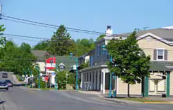
Saint-Lazare, Quebec
Saint-Lazare, also known as Saint-Lazare-de-Vaudreuil, is an off-island suburb of Montreal, in southwestern Quebec, Canada in the Regional County Municipality of Vaudreuil-Soulanges.
Saint-Lazare | |
|---|---|
 | |
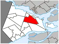 Location within Vaudreuil-Soulanges RCM. | |
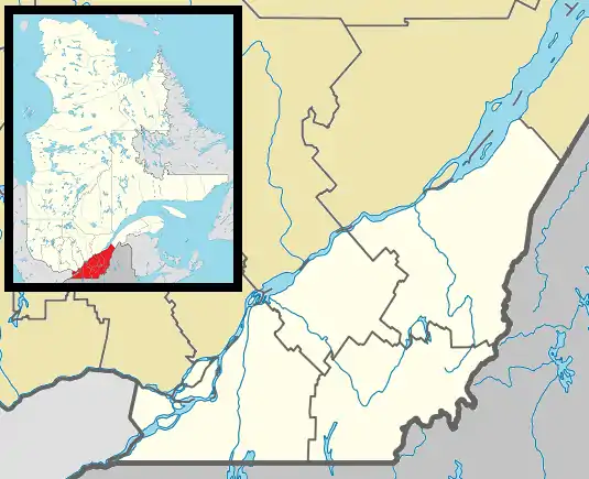 Saint-Lazare Location in southern Quebec. | |
| Coordinates: 45°24′N 74°08′W[1] | |
| Country | |
| Province | |
| Region | Montérégie |
| RCM | Vaudreuil-Soulanges |
| Constituted | 31 December 1875 |
| Government | |
| • Mayor | Robert Grimaudo |
| • Federal riding | Vaudreuil-Soulanges |
| • Prov. riding | Soulanges |
| Area | |
| • Land | 66.80 km2 (25.79 sq mi) |
| Population | |
| • Total | 19,889 |
| • Density | 297.8/km2 (771/sq mi) |
| • Pop 2011-2016 | |
| • Dwellings | 6,821 |
| Time zone | UTC−5 (EST) |
| • Summer (DST) | UTC−4 (EDT) |
| Postal code(s) | J7T |
| Area code(s) | 450 and 579 |
| Highways | |
| Website | www.ville. saint-lazare.qc.ca |
History
Originally part of the Seigneurie de Vaudreuil in the 18th century, the territory corresponding to Saint-Lazare was considered difficult to farm owing to sandy soil.
Saint-Lazare was founded as a parish on December 31, 1875. The first church was built in 1877, destroyed by a fire in 1942 and subsequently rebuilt in 1947.
A passenger train from Canadian Pacific Railway previously ran through the town but was discontinued in 1960. The station located on the corner of Sainte-Angélique and Duhamel was demolished.
Originally a rural farming town, the city of Saint-Lazare experienced rapid growth in the 1990s, fueled predominantly by the arrival of young, middle-class families.
New residents flocked to the area seeking a more relaxed lifestyle than that of the island of Montreal, as well as larger homes and property for less money than on the island of Montreal.
In 2015 the Saint-Lazare government began using pictograms instead of text on signs when the Office québécois de la langue française (OQLF) asked it to remove its English-language signs; the Saint-Lazare community believes in accommodating bilingualism and its Anglophone residents.[5]
Communities
- Saint-Lazare-de-Vaudreuil
- Saint-Lazare-Sud
- Saint-Lazare-Nord
- Saddlebrook
- Sandcastle
- Cedarbrook
- Sunnybrook
- Chanterel
- Forest Hill
- Maple Ridge
Demographics
Population
| Canada census – Saint-Lazare, Quebec community profile | |||
|---|---|---|---|
| 2016 | 2011 | 2006 | |
| Population: | 19,889 (+3.1% from 2011) | 19,295 (+13.4% from 2006) | 17,016 (+32.0% from 2001) |
| Land area: | 66.80 km2 (25.79 sq mi) | 66.62 km2 (25.72 sq mi) | 66.53 km2 (25.69 sq mi) |
| Population density: | 297.8/km2 (771/sq mi) | 289.6/km2 (750/sq mi) | 255.7/km2 (662/sq mi) |
| Median age: | 40.9 (M: 41.0, F: 40.9) | 38.4 (M: 38.7, F: 38.2) | 36.6 (M: 36.7, F: 36.4) |
| Total private dwellings: | 6,821 | 6,546 | 5,765 |
| Median household income: | $116,736 | $97,138 | $84,334 |
| References: 2016[6] 2011[7] 2006[8] earlier[9] | |||
|
|
Language
| Canada Census Mother Tongue - Saint-Lazare, Quebec[10] | ||||||||||||||||||
|---|---|---|---|---|---|---|---|---|---|---|---|---|---|---|---|---|---|---|
| Census | Total | French |
English |
French & English |
Other | |||||||||||||
| Year | Responses | Count | Trend | Pop % | Count | Trend | Pop % | Count | Trend | Pop % | Count | Trend | Pop % | |||||
2016 |
19,890 |
10,450 | 52.55% | 7,175 | 36.07% | 485 | 2.44% | 1,615 | 8.12% | |||||||||
2011 |
19,185 |
10,290 | 53.64% | 7,045 | 36.72% | 440 | 2.29% | 1,410 | 7.35% | |||||||||
2006 |
17,015 |
9,230 | 54.25% | 6,165 | 36.23% | 250 | 1.47% | 1,370 | 8.05% | |||||||||
2001 |
12,900 |
7,055 | 54.69% | 4,750 | 36.82% | 265 | 2.05% | 830 | 6.43% | |||||||||
1996 |
11,120 |
6,160 | n/a | 55.39% | 3,995 | n/a | 35.93% | 230 | n/a | 2.07% | 735 | n/a | 6.61% | |||||
Soils
Saint-Lazare was built on thick deposits of sand. Poorly drained areas are most common in the eastern part of town and have been mapped as muck, Peat or Vaudreuil series (a "half-bog" or gleysol), while the well to rapidly drained classic podzols are assigned to Ste. Sophie or Upland series.[11]
Attractions
Some of the popular attractions are:
- Aéroport Cooper
- Bar Chez Maurice
- Bar Planète St-Lazare
- Club équestre Les Forestiers
- Sports Complex
- Festivals
- Festival équestre Gymkhana
- Horse shows
- La Pinière
- Torchlight Parade (ATV)
- Trails and paths
- Canins canine sport center
Parks
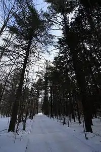
Saint-Lazare is graced by significant public funding for its ambitious recreational projects. Bedard Park in the centre of the town is a relatively large park equipped with a small water park, a grass field, three baseball diamonds, and tennis courts. In the winter two hockey rinks and an ice skating oval are added. The park hosts several events throughout the year, among the biggest of which is the annual St-Jean-de-Baptiste festival. Another large, multi-use park is called Le Parc nature les Forestiers de Saint-Lazare (2800 Chemin Lotbinière, Saint-Lazare, QC J7T 3H9). It is a 4-season park, with an outdoor pool, trails for hiking, cross-country skiing, horse riding, and snowshoeing, and picnic areas.
Other parks in Saint-Lazare are scattered among the small subdivisions throughout the municipality.
A new privately -financed sports centre was opened to the public in 2006 which includes an indoor soccer turf, a hockey rink, and a gym.
Equestrian
Areas surrounding Saint-Lazare are dedicated to equestrian horse riding, including sanctioned trails that flow through wooded forests and nearby lakes in the region. Many trails are sand based, which is due in part to the popularity of this type of activity in the region. The town has one of the largest populations of horses, approximately 3,500 with many residential properties fully dedicated to breeding and horse training.
ATV
All-terrain vehicles are very popular in the region with an officially sanctioned trail, which runs between Saint-Lazare and the nearby town of Rigaud, Quebec. The trail is maintained by regional members of local ATV clubs. The trails are open in all four seasons, and groomed in the winter using heavy machinery.
Infrastructure
Transportation
The city is served by the 51 bus from the Exo La Presqu’Île, terminating at the Vaudreuil train station.
Education
Commission Scolaire des Trois-Lacs operates Francophone schools.[12]
- École à l'Orée-du-Bois
- École Auclair
- École des Étriers
- Sections are zoned to École Saint-Thomas in Hudson[13]
There is one French language public high school (École secondaire Cité-des-Jeunes in Vaudreuil-Dorion) in the area.
Lester B. Pearson School Board operates Anglophone schools.[14]
- Birchwood Elementary School
- Evergreen Elementary School
- Forest Hill Elementary School
- A portion is zoned to Mount Pleasant Elementary School in Hudson
- Westwood High School-Junior Campus (the senior campus is in Hudson)
A new senior elementary school, Forest Hill Senior, was opened in 2006. There are also two English language public secondary schools in the surrounding area (Westwood Senior - formerly Hudson High School - and Westwood Junior-formerly known as Vaudreuil Catholic High School). A new English-language elementary school (Birchwood Elementary) has opened for the 2011–2012 school year, even after many delays in construction.
There is a semi-private French-speaking institution in Rigaud (Collège-Bourget).
Sports clubs
- St-Lazare Hudson Soccer Club
- St-Lazare Hudson Taekwondo
- HRS Hockey
See also
References
- Reference number 369778 of the Commission de toponymie du Québec (in French)
- Ministère des Affaires municipales, des Régions et de l'Occupation du territoire: Saint-Lazare
- Parliament of Canada Federal Riding History: VAUDREUIL--SOULANGES (Quebec)
- https://www12.statcan.gc.ca/census-recensement/2016/dp-pd/prof/details/page.cfm?Lang=E&Geo1=CSD&Code1=2471105&Geo2=PR&Code2=24&SearchText=Saint-Lazare&SearchType=Begins&SearchPR=01&B1=All&GeoLevel=PR&GeoCode=2471105&TABID=1&type=0
- Hopper, Tristin (27 November 2015). "Quebec town makes stand for English: Told to remove 'welcome' sign, decides to drop French too". National Post. Retrieved 25 December 2018.
- "2016 Community Profiles". 2016 Canadian Census. Statistics Canada. 21 February 2017. Retrieved 8 January 2021.
- "2011 Community Profiles". 2011 Canadian Census. Statistics Canada. 5 July 2013. Retrieved 19 February 2014.
- "2006 Community Profiles". 2006 Canadian Census. Statistics Canada. 30 March 2011. Retrieved 19 February 2014.
- "2001 Community Profiles". 2001 Canadian Census. Statistics Canada. 17 February 2012.
- Statistics Canada: 1996, 2001, 2006, 2011, 2016 census
- http://sis.agr.gc.ca/cansis/publications/surveys/pq/pq53/pq53_report.pdf Lajoie and Stobbe, (1951). Soil Survey of Soulanges and Vaudreuil Counties in the Province of Quebec
- "Les écoles et les centres". Commission Scolaire des Trois-Lacs. Retrieved 18 January 2013.
- "Liste des bassins desservis par les écoles en 2017-2018." Commission Scolaire des Trois-Lacs. Retrieved on 30 September 2017.
- "School Board Map." Lester B. Pearson School Board. Retrieved on 28 September 2017.
External links
| Wikimedia Commons has media related to Saint-Lazare, Quebec. |
Adjacent Municipalities | |
|---|---|
| Cities & towns | |
|---|---|
| Municipalities | |
| Villages | |
| |