Lucinges
Lucinges is a commune in the Haute-Savoie department in the Auvergne-Rhône-Alpes region in south-eastern France.
Lucinges | |
|---|---|
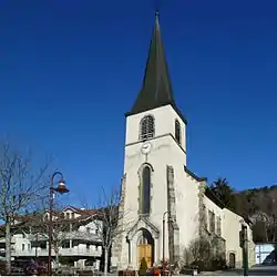 The church in Lucinges | |
 Coat of arms | |
Location of Lucinges 
| |
 Lucinges  Lucinges | |
| Coordinates: 46°11′26″N 6°19′08″E | |
| Country | France |
| Region | Auvergne-Rhône-Alpes |
| Department | Haute-Savoie |
| Arrondissement | Saint-Julien-en-Genevois |
| Canton | Gaillard |
| Intercommunality | Annemasse - Les Voirons Agglomération |
| Government | |
| • Mayor (2014–2020) | Jean-Luc Soulat |
| Area 1 | 7.69 km2 (2.97 sq mi) |
| Population (2017-01-01)[1] | 1,625 |
| • Density | 210/km2 (550/sq mi) |
| Time zone | UTC+01:00 (CET) |
| • Summer (DST) | UTC+02:00 (CEST) |
| INSEE/Postal code | 74153 /74380 |
| Elevation | 525–1,400 m (1,722–4,593 ft) |
| Website | Lucinges.fr |
| 1 French Land Register data, which excludes lakes, ponds, glaciers > 1 km2 (0.386 sq mi or 247 acres) and river estuaries. | |
References
- "Populations légales 2017". INSEE. Retrieved 6 January 2020.
| Wikimedia Commons has media related to Lucinges. |
| Authority control |
|---|
This article is issued from Wikipedia. The text is licensed under Creative Commons - Attribution - Sharealike. Additional terms may apply for the media files.