Jonzier-Épagny
Jonzier-Épagny is a commune in the Haute-Savoie départment in the Auvergne-Rhône-Alpes region in south-eastern France.
Jonzier-Épagny | |
|---|---|
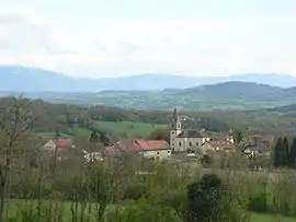 A general view of Jonzier-Épagny | |
 Coat of arms | |
Location of Jonzier-Épagny 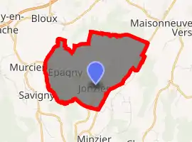
| |
 Jonzier-Épagny  Jonzier-Épagny | |
| Coordinates: 46°04′17″N 5°59′26″E | |
| Country | France |
| Region | Auvergne-Rhône-Alpes |
| Department | Haute-Savoie |
| Arrondissement | Saint-Julien-en-Genevois |
| Canton | Saint-Julien-en-Genevois |
| Intercommunality | Communauté de communes du Genevois |
| Government | |
| • Mayor (2014–2020) | Michel Mermin |
| Area 1 | 7.16 km2 (2.76 sq mi) |
| Population (2017-01-01)[1] | 798 |
| • Density | 110/km2 (290/sq mi) |
| Time zone | UTC+01:00 (CET) |
| • Summer (DST) | UTC+02:00 (CEST) |
| INSEE/Postal code | 74144 /74520 |
| Elevation | 518–733 m (1,699–2,405 ft) |
| 1 French Land Register data, which excludes lakes, ponds, glaciers > 1 km2 (0.386 sq mi or 247 acres) and river estuaries. | |
The commune comprises three hamlets (Les Barraques, Épagny, Vigny) and a place named Mont-Sion.
Geography
The commune covers 716 ha of glacial moraine from the Rhône, deposited about 10,000 years ago, and called the Montagne de Sion. The highest point in the commune is at 733 m.
See also
| Wikimedia Commons has media related to Jonzier-Épagny. |
References
- "Populations légales 2017". INSEE. Retrieved 6 January 2020.
| Authority control |
|---|
This article is issued from Wikipedia. The text is licensed under Creative Commons - Attribution - Sharealike. Additional terms may apply for the media files.