Saint-Pierre-en-Faucigny
Saint-Pierre-en-Faucigny is a commune in the Haute-Savoie department and Auvergne-Rhône-Alpes region of eastern France.
Saint-Pierre-en-Faucigny | |
|---|---|
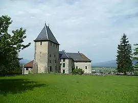 The Château of Rumilly-sous-Cornillon, in Saint-Pierre-en-Faucigny | |
.svg.png.webp) Coat of arms | |
Location of Saint-Pierre-en-Faucigny 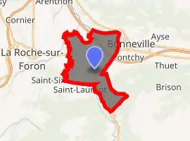
| |
 Saint-Pierre-en-Faucigny  Saint-Pierre-en-Faucigny | |
| Coordinates: 46°03′38″N 6°22′23″E | |
| Country | France |
| Region | Auvergne-Rhône-Alpes |
| Department | Haute-Savoie |
| Arrondissement | Bonneville |
| Canton | Bonneville |
| Intercommunality | Communauté de communes du Pays Rochois |
| Government | |
| • Mayor (2020–2026) | Marin Gaillard[1] |
| Area 1 | 14.91 km2 (5.76 sq mi) |
| Population (2017-01-01)[2] | 6,573 |
| • Density | 440/km2 (1,100/sq mi) |
| Demonym(s) | Saint-Pierrois / Saint-Pierroise |
| Time zone | UTC+01:00 (CET) |
| • Summer (DST) | UTC+02:00 (CEST) |
| INSEE/Postal code | 74250 /74800 |
| Elevation | 433–1,500 m (1,421–4,921 ft) |
| 1 French Land Register data, which excludes lakes, ponds, glaciers > 1 km2 (0.386 sq mi or 247 acres) and river estuaries. | |
The urban center is located in the province of Faucigny. The town had 6,389 inhabitants in 2016. It was born from the fusion in 1965 of the communes of Passeirier, Saint-Maurice-de-Rumilly and Saint-Pierre-de-Rumilly.
Saint-Pierre-en-Faucigny is situated between Bonneville and La Roche-sur-Foron.
Transport
The commune has a railway station, Saint-Pierre-en-Faucigny, on the La Roche-sur-Foron–Saint-Gervais-les-Bains-Le Fayet line.
Twin towns — sister cities
Saint-Pierre-en-Faucigny is twinned with Saint-Pierre, Aosta Valley, Italy.
References
- "Répertoire national des élus: les maires". data.gouv.fr, Plateforme ouverte des données publiques françaises (in French). 2 December 2020. Retrieved 7 December 2020.
- "Populations légales 2017". INSEE. Retrieved 6 January 2020.
| Wikimedia Commons has media related to Saint-Pierre-en-Faucigny. |
| Authority control |
|
|---|
This article is issued from Wikipedia. The text is licensed under Creative Commons - Attribution - Sharealike. Additional terms may apply for the media files.