Seyssel, Haute-Savoie
Seyssel is a commune in the Haute-Savoie department in the Auvergne-Rhône-Alpes region in south-eastern France.
Seyssel | |
|---|---|
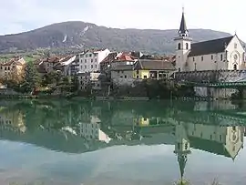 The village seen from the West | |
.svg.png.webp) Coat of arms | |
Location of Seyssel 
| |
 Seyssel  Seyssel | |
| Coordinates: 45°57′35″N 5°50′14″E | |
| Country | France |
| Region | Auvergne-Rhône-Alpes |
| Department | Haute-Savoie |
| Arrondissement | Saint-Julien-en-Genevois |
| Canton | Saint-Julien-en-Genevois |
| Government | |
| • Mayor (2014–2020) | Gilles Pilloux |
| Area 1 | 16.86 km2 (6.51 sq mi) |
| Population (2017-01-01)[1] | 2,325 |
| • Density | 140/km2 (360/sq mi) |
| Time zone | UTC+01:00 (CET) |
| • Summer (DST) | UTC+02:00 (CEST) |
| INSEE/Postal code | 74269 /74910 |
| Elevation | 250–937 m (820–3,074 ft) (avg. 265 m or 869 ft) |
| 1 French Land Register data, which excludes lakes, ponds, glaciers > 1 km2 (0.386 sq mi or 247 acres) and river estuaries. | |
The part of the town across the Rhône is also named Seyssel but located on the western bank of the Rhône in the Ain department. It is a rare case in France of two homonymous communes adjacent to each other, similar to the situation of the village of Saint-Santin, divided between the communes of Saint-Santin (Aveyron) and Saint-Santin-de-Maurs (Cantal).
Geography
The Fier forms most of the commune's southern border, then flows into the Rhone, which forms the commune's western border.
References
- "Populations légales 2017". INSEE. Retrieved 6 January 2020.
| Wikimedia Commons has media related to Seyssel, Haute-Savoie. |
| Authority control |
|---|
This article is issued from Wikipedia. The text is licensed under Creative Commons - Attribution - Sharealike. Additional terms may apply for the media files.