Maine State Route 11
State Route 11 (SR 11) is a state highway in the U.S. state of Maine. It is a continuation of New Hampshire Route 11 at its south end in Lebanon, which itself is a continuation of Vermont Route 11. SR 11 in Maine travels through the counties of York, Cumberland, Androscoggin, Kennebec, Somerset, Waldo, Penobscot, Piscataquis, Aroostook. The road ends at U.S. Route 1 (US 1) and SR 161 in Fort Kent, near the Canada–US border.
| |||||||
|---|---|---|---|---|---|---|---|
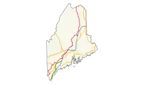 Route of SR 11 highlighted in red | |||||||
| Route information | |||||||
| Maintained by MaineDOT | |||||||
| Length | 401.2 mi[1] (645.7 km) | ||||||
| Major junctions | |||||||
| South end | |||||||
| North end | |||||||
| Location | |||||||
| Counties | York, Cumberland, Androscoggin, Kennebec, Somerset, Waldo, Penobscot, Piscataquis, Aroostook | ||||||
| Highway system | |||||||
| |||||||

At just over 401 miles (645 km), SR 11 is the longest state highway in Maine, and the second longest numbered highway in the entire state (behind US 1, which runs just over 527 miles (848 km) in Maine). It is almost 100 miles (160 km) longer than Maine's longest Interstate Highway, its 303-mile (488 km) section of Interstate 95 (I-95). Overall, Route 11 in Maine, New Hampshire, and Vermont are 551.7 miles (887.9 km) long.
History
New England Interstate Route 11

The short portion from Claremont to Sanford was part of New England Interstate Route 11. The old Route 11 used to continue east to Biddeford on what is now SR 111.
SR 211
Maine State Route 211 was a route designated in 1925. It ran from SR 157 (now SR 11/SR 157) to SR 158 (now SR 11/SR 158). The entire routing was replaced by SR 11 in 1926.
Junction list
| County | Location | mi | km | Destinations | Notes |
|---|---|---|---|---|---|
| York | Lebanon | 0.0 | 0.0 | Continuation into New Hampshire Southern terminus of concurrency with US 202 | |
| Sanford | 9.1 | 14.6 | Southern terminus of SR 11A (southern segment) | ||
| 12.5 | 20.1 | Northern terminus of concurrency with US 202 Southern terminus of concurrency with SR 109 | |||
| 14.5 | 23.3 | Village of Springvale Northern terminus of SR 11A (southern segment) Western terminus of SR 224 | |||
| Shapleigh | 18.6 | 29.9 | Northern terminus of concurrency with SR 109 | ||
| Newfield | 29.3 | 47.2 | Eastern terminus of SR 110 | ||
| Limerick | 36.5 | 58.7 | Southern terminus of concurrency with SR 5 | ||
| 36.7 | 59.1 | Northern terminus of concurrency with SR 5 | |||
| Limington | 42.6 | 68.6 | |||
| 44.5 | 71.6 | ||||
| Cumberland | Standish | 48.2 | 77.6 | Village of Steep Falls Southern terminus of concurrency with SR 113 | |
| Baldwin | 49.7 | 80.0 | Northern terminus of concurrency with SR 113 Southern terminus of SR 107 | ||
| 51.5 | 82.9 | Northern terminus of concurrency with SR 107 | |||
| Sebago | 54.1 | 87.1 | Southern terminus of concurrency with SR 114 | ||
| Naples | 63.4 | 102.0 | Western terminus of concurrency with US 302 Northern terminus of SR 114 | ||
| 63.9 | 102.8 | Western terminus of concurrency with US 302/SR 35 | |||
| 64.8 | 104.3 | Eastern terminus of concurrency with US 302/SR 35 | |||
| Casco | 68.8 | 110.7 | |||
| 71.0 | 114.3 | Northern terminus of SR 85 | |||
| Androscoggin | Poland | 78.2 | 125.9 | ||
| Mechanic Falls | 81.0 | 130.4 | Western terminus of concurrency with SR 121 | ||
| Minot | 84.5 | 136.0 | Southern terminus of SR 119 | ||
| Auburn | 89.8 | 144.5 | Rotary Southern terminus of concurrency with US 202/SR 4/100 Eastern terminus of SR 121 | ||
| 90.5 | 145.6 | Northern terminus of concurrency with SR 4 | |||
| 90.8 | 146.1 | Northern terminus of SR 136 | |||
| Lewiston | 91.2 | 146.8 | Western terminus of SR 196 | ||
| 91.4 | 147.1 | Western terminus of SR 126 | |||
| 92.2 | 148.4 | Russell Street– | Interchange | ||
| Leeds | 103.1 | 165.9 | Southern terminus of SR 106 | ||
| Kennebec | Monmouth | 107.2 | 172.5 | Northern terminus of SR 132 | |
| Winthrop | 110.6 | 178.0 | Interchange Southern terminus of SR 41 and SR 133 | ||
| 113.6 | 182.8 | Western terminus of concurrency with SR 135 | |||
| 113.7 | 183.0 | Eastern terminus of concurrency with SR 135 | |||
| Manchester | 116.9 | 188.1 | Western terminus of concurrency with SR 17 | ||
| Augusta | 119.6 | 192.5 | Exit 109 on I-95 (Maine Turnpike) | ||
| 121.1 | 194.9 | Rotary Northern terminus of concurrency with US 202/SR 17/100 Southern terminus of concurrency with SR 8/27 | |||
| 121.8 | 196.0 | Southern terminus of SR 104 | |||
| 124.0 | 199.6 | Exit 112 on I-95 | |||
| Sidney | 127.6 | 205.4 | Southern terminus of SR 23 | ||
| Belgrade | 132.8 | 213.7 | Northern terminus of concurrency with SR 27 | ||
| 133.2 | 214.4 | Northern terminus of SR 135 | |||
| 136.0 | 218.9 | Northern terminus of concurrency with SR 8 | |||
| Oakland | 140.9 | 226.8 | |||
| 141.4 | 227.6 | Western terminus of concurrency with SR 137 | |||
| 141.7 | 228.0 | ||||
| Waterville | 143.5 | 230.9 | Exit 127 on I-95 | ||
| 145.1 | 233.5 | Southern terminus of concurrency with SR 104 | |||
| 145.2 | 233.7 | Eastern terminus of concurrency with SR 137 | |||
| 145.9 | 234.8 | Southern terminus of SR 137 Bus. | |||
| 146.4 | 235.6 | US 201/SR 100 one-way southbound on Main Street Southern terminus of concurrency with US 201/SR 100 Northern terminus of concurrency with SR 104 | |||
| 146.8 | 236.3 | Northbound US 201/SR 100 join from one-way Front Street | |||
| Somerset | Fairfield | 149.6 | 240.8 | Northern terminus of concurrency with US 201 Western terminus of concurrency with SR 139 | |
| Kennebec | Benton | 151.7 | 244.1 | Northern terminus of SR 100A | |
| 151.8 | 244.3 | Eastern terminus of concurrency with SR 139 | |||
| Clinton | 156.0 | 251.1 | Baker Street/Hinckley Road– | To Exit 138 on I-95 | |
| Somerset | Pittsfield | 169.0 | 272.0 | Western terminus of SR 69 | |
| 169.1 | 272.1 | Southern terminus of SR 152 | |||
| Palmyra | 173.0 | 278.4 | Northern terminus of SR 220 | ||
| 175.4 | 282.3 | Exit 157 on I-95 | |||
| Penobscot | Newport | 175.8 | 282.9 | Northern terminus of concurrency with SR 100 Southern terminus of concurrency with SR 7 | |
| Corinna | 181.9 | 292.7 | Western terminus of concurrency with SR 43 | ||
| 182.0 | 292.9 | Northern terminus of concurrency with SR 7 Western terminus of SR 222 | |||
| Corinth | 196.1 | 315.6 | Eastern terminus of SR 94 | ||
| 197.7 | 318.2 | Southern terminus of concurrency with SR 15 | |||
| 197.8 | 318.3 | Eastern terminus of concurrency with SR 43 | |||
| Charleston | 199.5 | 321.1 | Northern terminus of concurrency with SR 15 | ||
| 201.2 | 323.8 | Southern terminus of SR 11A (northern segment) | |||
| Bradford | 206.1 | 331.7 | Northern terminus of SR 221 Southern terminus of SR 155 | ||
| 208.3 | 335.2 | Northern terminus of SR 11A (northern segment) | |||
| Piscataquis | Milo | 218.4 | 351.5 | Southern terminus of concurrency with SR 6/16 | |
| 220.6 | 355.0 | Northern terminus of concurrency with SR 6/16 | |||
| Penobscot | Millinocket | 259.2 | 417.1 | Western terminus of SR 11B | |
| 259.5 | 417.6 | Katahdin Avenue – Baxter State Park | Western terminus of SR 157 | ||
| 259.7 | 417.9 | Eastern terminus of SR 11B | |||
| Medway | 269.3 | 433.4 | Northern terminus of SR 116 | ||
| 270.0 | 434.5 | Eastern terminus of concurrency with SR 157 | |||
| Aroostook | Sherman | 295.0 | 474.8 | Western terminus of SR 158 To Exit 264 | |
| Penobscot | Patten | 303.9 | 489.1 | Southern terminus of concurrency with SR 159 | |
| 304.3 | 489.7 | Northern terminus of concurrency with SR 159 | |||
| Aroostook | Moro Plantation | 320.2 | 515.3 | Western terminus of SR 212 | |
| Ashland | 351.2 | 565.2 | Western terminus of SR 163 | ||
| 351.5 | 565.7 | Western terminus of SR 227 | |||
| Fort Kent | 399.7 | 643.3 | Northern terminus of SR 11 | ||
1.000 mi = 1.609 km; 1.000 km = 0.621 mi
| |||||
Alternate routes
SR 11A (Sanford)
| |
|---|---|
| Location | Sanford |
| Length | 3.3 mi[2] (5.3 km) |
| Existed | 1931–present |
SR 11A is located entirely in the town of Sanford and is 3.3 miles (5.3 km) in length. Locally it is known as Oak Street.
SR 11A (Charleston)
| |
|---|---|
| Location | Charleston–Bradford |
| Length | 6.7 mi[2] (10.8 km) |
| Existed | 1980s–present |
SR 11A is 6.7-mile-long (10.8 km) and is a former designation of SR 1. SR 11A has a southern terminus in Charleston and a northern terminus in Bradford.
SR 11B
| |
|---|---|
| Location | Millinocket |
| Length | 0.30 mi[3] (0.48 km) |
SR 11B is a 0.3-mile-long (0.48 km) business route of SR 11 in Millinocket. Most of the route travels along one-way Penobscot Avenue through the central business district of the town. It begins at the intersection of Central Street (SR 11 / SR 157) and Penobscot Avenue and travels south to Poplar Street. It then turns west along Poplar Street and becomes a two-way street for one block before ending at Katahdin Avenue (SR 11). Signage for the route is only posted for the south and westbound traffic, no signage is posted along SR 11 at Poplar Street or Katahdin Avenue.[3]
See also
References
- Maine State Route log via floodgap.com
- Floodgap Roadgap's RoadsAroundME: Maine State Route 11A Archived 2012-03-12 at Archive.today
- Google (May 7, 2017). "SR 11B" (Map). Google Maps. Google. Retrieved May 7, 2017.