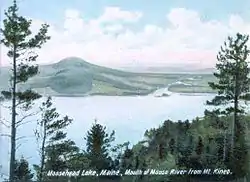
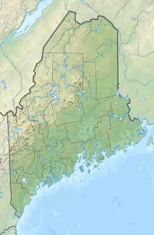
Moosehead Lake
Moosehead Lake is a deep, coldwater lake located in Northwestern Maine. It is the Second Largest Lake in New England, and the largest mountain lake in the eastern United States. Situated in the mostly undeveloped Longfellow Mountains, the lake is the source of the Kennebec River. Several rural Townships border the lake. Greenville is by far the largest settlement on the lake, with a small downtown area that includes banks, shops, and restaurants. There are over 80 islands in the lake, the largest being Sugar Island with the almost as large Deer Island to the west.
| Moosehead Lake | |
|---|---|
 | |
 Moosehead Lake | |
| Location | Northwest Piscataquis, Maine, United States |
| Coordinates | 45°38′N 69°39′W |
| Type | mesotrophic |
| Primary inflows | Moose River |
| Primary outflows | Kennebec River |
| Catchment area | 1,268 square miles (3,280 km2) |
| Basin countries | United States |
| Max. length | 30 miles (48 km) |
| Max. width | 10 miles (16 km) |
| Surface area | 75,451 acres (30,534 ha) |
| Average depth | 55 feet (17 m) |
| Max. depth | 246 feet (75 m) |
| Water volume | 4,210,000 acre⋅ft (5.19×10⁹ m3) |
| Residence time | 3.1 years |
| Shore length1 | 280.8 miles (451.9 km) |
| Surface elevation | 1,029 feet (314 m) |
| Islands | >80 (Sugar Island) |
| 1 Shore length is not a well-defined measure. | |
History
Mount Kineo, with 700-foot (200 m) cliffs rising straight up from Moosehead Lake, has attracted visitors for centuries, from early American Indians (Red Paint People), to later tribes seeking its rhyolite to make stone tools, Penobscots and Norridgewocks, the Abenaki bands who battled here with their enemy the Mohawks, to 19th-century "rusticators" traveling by railroad and steamboat and today's hotel guests. Various species dwell among its cliffs and talus slopes, including peregrine falcons and rare plants.
The Moosehead region includes the headwaters of the Kennebec, the West Branch of the Penobscot, the Piscataquis, the Pleasant, and the Saint John rivers. Henry David Thoreau and other 19th-century visitors remarked on the beauty of the area. The region has a large moose population; moose outnumber people 3:1.[1] However, the name of the region derives from the remarkable similarity between maps of the lake and an antlered moose.
Henry David Thoreau described the lake as “...a gleaming silver platter at the end of the table.”[2]
Geography

Set at an elevation of 1,023 feet (312 m), Moosehead Lake is approx. 30 by 10 miles (64 by 16 km), with an area of nearly 118 mile² (approx. 303 km²), and over 400 miles (640 km) of shoreline. Its major inlet is the Moose River, which, east of Jackman, flows through Long Pond to Brassua Lake. To the east of Moosehead Lake, the Roach River is its second largest tributary. Flowing out of Moosehead Lake to the southwest are its east and west outlets—the Kennebec River.
The Moosehead Lake Region encompasses 4,400 square miles (11,000 km²) of North Central Maine, and includes 127 incorporated and unincorporated townships in addition to Moosehead Lake. The region is drained by 330 miles (530 km) of main stem rivers, into which flow 3,850 miles (6,200 km) of smaller tributaries. During the last glacial era, more than 1,200 natural lakes and ponds were carved into its landscape, varying in size from one acre (4,000 m²) ponds to Moosehead, at 75,451 acres (303 km²) one of the largest natural freshwater lakes in the United States. The total area of all standing surface waters in the region is more than 238,000 acres (963 km²)—24% of the total area of lakes and ponds in Maine.
Development plans
Seattle-based Plum Creek Real Estate Investment Corporation, the largest private United States landowner, submitted a development proposal for the Moosehead region in April 2005. It was the largest development ever proposed for the state of Maine.[3] The initial version of the scheme called for 975 house lots, two resorts, a golf course, a marina, three RV parks, and more than 100 rental cabins.[4] However, Plum Creek was defunct as of 2016 and all development plans have been cancelled.
In January 2021, A $75-Million Dollar investment was made into developing the 1,700-acre Big Squaw Mountain Resort into a year-round tourist attraction that would include a new ski-lift system, a large hotel, lakefront condominiums, and a marina. The Plans are being made by local developer Perry Williams, along with Louisiana-based developers at Provident Resources Group. [5]
References
- "Four-Star lodging at the Lodge at Moosehead Lake, Greenville, Maine". www.visitingnewengland.com. Retrieved 21 April 2018.
- Weber, Alan (2003-04-09). Because It's There: A Celebration of Mountaineering from 200 B.C. to Today. Taylor Trade Publications. ISBN 9780878333035.
- "Plum Creek: An Update". Natural Resources Council of Maine. Archived from the original on 2013-04-15.
- Tanuki (September 29, 2008). "Another Act of Resistance to Plum Creek by Maine Earth First!". Maine Earth First. Archived from the original on July 23, 2011.
- https://bangordailynews.com/2021/01/20/news/piscataquis/knox-county-developer-proposes-75m-ski-resort-by-moosehead-lake/
Further reading
- Parker, Everett L. The Moosehead Lake Region: 1900-1950. Images of America. ISBN 9781439631881.
External links
- Moosehead Lake Region Chamber of Commerce
- History of Moosehead Lake Region, Moosehead Historical Society
- Natural Resources Council of Maine
- The Moosehead Lake Region Resource Guide
- Land Use Regulation Committee - Concept Plan for Moosehead Lake Region
- Moosehead Lake Webcam
| Authority control |
|---|