Mangwe District
Mangwe District is a district of the Province Matabeleland South in Zimbabwe.[1][2] It is divided into 17 wards. Some of the wards are Ngwizi, Mphoengs, Sanzukwi, Sangulube, Maninji, Madabe, Mbakwe, Empandeni, Mayobodo, Mambale, Makorokoro, Tshitshi, and Marula.[3] Some villages found in this district are Bulu, Kweneng, Togotsweu.[4] Mangwe used to be a part of bigger district which was known as Bulilimamangwe. Bulilimamangwe was then divided into 3 districts now known as Mangwe, Bulilima and Plumtree.
Mangwe District | |
|---|---|
Second-level administrative subdivision | |
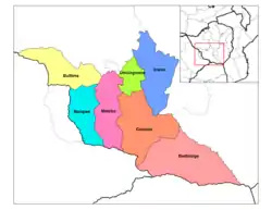 A map of the districts of Matabeleland South | |
| Country | Zimbabwe |
| Province | Matabeleland South |
| Time zone | UTC+1 (CET) |
| • Summer (DST) | UTC+1 (CEST) |
Demographics
Mangwe has a total population of 65 629 people: 42 974 Males and 51 387 Females
Education
In Mangwe District there are about 45 primary schools and 15 secondary schools
Health
Mangwe has 13 health facilities: three hospitals and ten clinics. Of the 13 health facilities, four are mission owned whilst the rest belong to the government.
Business Centres
There are 15 business centres in Mangwe,
References
- "Zimbabwe: Administrative Division". City Population. Retrieved 30 December 2018.
- "Census 2012" (PDF). UNSD. UNSD. Retrieved 30 December 2018.
- "A CONSTITUENCY PROFILE OF MANGWE" (PDF). Zimbabwe Election Support Network. Retrieved 13 September 2020.
- "Togotsweu Mine in Mangwe district". #Asakhe - CITE. 9 June 2020. Retrieved 13 September 2020.