Bulawayo
Bulawayo (/bʊləˈwɑːjoʊ/, /-ˈweɪoʊ/;[3] Ndebele: Bulawayo) is the second largest city in Zimbabwe, and the largest city in the country's Matabeleland region. The city's population is disputed; the 2012 census listed it at 653,337, while the Bulawayo City Council claimed it to be about 1.2 million. Bulawayo covers an area of about 1,707 square kilometres (659 square miles) in the western part of the country, along the Matsheumhlope River. Along with the capital Harare, Bulawayo is one of two cities in Zimbabwe that is also a province.
Bulawayo
Bulawayo | |
|---|---|
City and Province | |
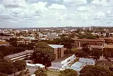
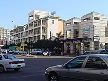
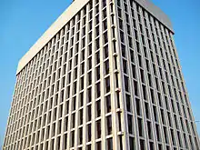
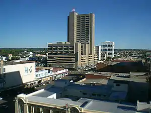 View of Bulawayo's Central Business District (CBD) from Pioneer House by Prince Phumulani Nyoni. The CBD is 5.4 square kilometres and is in a grid pattern with 17 avenues and 11 streets. | |
 Flag  Coat of arms | |
| Nickname(s): 'City of Kings', 'Skies', 'Bluez', 'Bompton' or 'Bulliesberg' | |
| Motto(s): (In Sindebele) Si ye pambili (Let us go forward) | |
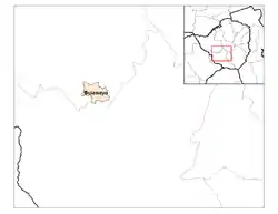 Location of Bulawayo Province | |
 Bulawayo Location of Bulawayo Province | |
| Coordinates: 20°10′12″S 28°34′48″E | |
| Country | Zimbabwe |
| Province | Bulawayo |
| District | City of Bulawayo |
| Settled | 1840 |
| Incorporated (town) | 1897 |
| Incorporated (city) | 1943 |
| Divisions | 4 Districts, 29 Wards, 156 Suburbs |
| Government | |
| • Type | Provincial Municipality |
| • Mayor | Solomon Mguni MDC-T |
| Area | |
| • City and Province | 1,706.8 km2 (659.0 sq mi) |
| • Water | 129.3 km2 (49.9 sq mi) |
| • Urban | 993.5 km2 (383.6 sq mi) |
| • Metro | 1,706.8 km2 (659.0 sq mi) |
| Elevation | 1,358 m (4,455 ft) |
| Population (2016) | |
| • City and Province | 1,200,337 |
| • Density | 700/km2 (1,800/sq mi) |
| • Urban | 1,205,675 |
| • Urban density | 2,305/km2 (5,970/sq mi) |
| Time zone | UTC+2 (CAT) |
| • Summer (DST) | UTC+2 (not observed) |
| Area code(s) | 029 |
| HDI (2018) | 0.670[2] medium · 1st |
| Website | citybyo |
Bulawayo was founded around 1840 as the kraal of Mzilikazi, the Ndebele king. His son, Lobengula, succeeded him in the 1860s, and ruled from Bulawayo until 1893, when the settlement was captured by British South Africa Company soldiers during the First Matabele War. That year, the first white settlers arrived and rebuilt the town. The town was besieged by Ndebele warriors during the Second Matabele War. Bulawayo attained municipality status in 1897, and city status in 1943.
Historically, Bulawayo has been the principal industrial center of Zimbabwe; its factories produce cars and car products, building materials, electronic products, textiles, furniture, and food products. Bulawayo is also the hub of Zimbabwe's rail network and the headquarters of the National Railways of Zimbabwe. In recent years, the city's economy has struggled, as many factories either closed or moved operations to Harare. Still, Bulawayo has the highest Human Development Index in the country, at 0.649 as of 2017.
Bulawayo's central business district (CBD) covers 5.4 km2 (2 1⁄8 sq mi) in the heart of the city, and is surrounded by numerous suburbs towards the outskirts. The majority of the city's population belong to the Ndebele people, with minorities of Shona and other groups. Bulawayo is home to over a dozen colleges and universities, most notably the National University of Science and Technology, Bulawayo Polytechic College Bulawayo Polytechnic, Zimbabwe School of Mines, United College of Education to name but a few. The Natural History Museum of Zimbabwe, formerly the National Museum, is located in Bulawayo. The city is in close proximity to tourist sites such as Matobo National Park and the Khami World Heritage Site.
History

The city was founded by the Ndebele king, Lobhengula, the son of King Mzilikazi, born of Matshobana, who settled in modern-day Zimbabwe around the 1840s. This followed the Ndebele people's great trek from northern Kwazulu. The name Bulawayo comes from the Ndebele word bulala and it translates to "the one to be killed". It is thought that, at the time of the formation of the city, there was a civil war. Mbiko Masuku, a trusted confident of King Mzilikazi and leader of the Zwangendaba regiment fought Prince Lobengula as he did not believe that he was the legitimate heir to the throne. This was because Lobhengula was born to a Swazi mother and Mbiko ka Madlenya Masuku felt that she was of a lesser class. He named his capital "the place of the one to be killed".
At the time Lobengula, was a prince fighting to ascend to the throne of his father Mzilikazi. It was common at the time for people to refer to Bulawayo as "Bulawayo UmntwaneNkosi", "a place where they are fighting or rising against the prince". The city of Bulawayo coincidentally has a similar name as the capital of the great Zulu warrior king Shaka ka Senzangakhona in Kwazulu, where Mzilikazi and his Khumalo clan and other Nguni people came from.
In the 1860s, the city was influenced by European intrigue. Many colonial powers cast covetous eyes on Bulawayo and the land surrounding it because of its strategic location. Britain made skillful use of private initiative in the shape of Cecil Rhodes and the Chartered Company to disarm the suspicion of her rivals. Lobengula once described Britain as a chameleon and himself as the fly.[4]
During the 1893 Matabele War, British South Africa Company troops invaded and forced King Lobengula to evacuate his followers, after first detonating munitions and setting fire to the town.[5] BSAC troops and white settlers occupied the ruins. On 4 November 1893, Leander Starr Jameson declared Bulawayo a settlement under the rule of the British South Africa Company. Cecil Rhodes ordered the new settlement to be founded on the ruins of Lobengula's royal kraal, a typical action by a conquering power. This is where the State House stands today.[6]
In 1897, the new town of Bulawayo acquired the status of municipality in the British colonial system, and Lt. Col. Harry White was appointed as one of the first mayors.[6][7]
Siege
At the outbreak of the Second Matabele War, in March 1896, Bulawayo was besieged by Ndebele forces. The settlers established a laager here for defensive purposes. The Ndebele had suffered the brutal effectiveness of the British Maxim guns in the First Matabele War, so they never mounted a significant attack against Bulawayo, although over 10,000 Ndebele warriors gathered to surround the town. Rather than wait passively for attack, the settlers mounted patrols, called the Bulawayo Field Force, under Frederick Selous and Frederick Russell Burnham. These patrols rode out to rescue any surviving settlers in the countryside and attacked the Ndebele. In the first week of fighting, 20 men of the Bulawayo Field Force were killed and 50 were wounded. An unknown number of Ndebele were killed and wounded.
During the siege, conditions in Bulawayo quickly deteriorated. By day, settlers could go to homes and buildings in the town, but at night they were forced to seek shelter in the much smaller laager. Nearly 1,000 women and children were crowded into the small area and false alarms of attacks were common. The Ndebele neglected to cut the telegraph lines connecting Bulawayo to Mafikeng. The settlers and forces appealed for relief, and the British sent additional troops from Salisbury and Fort Victoria (now Harare and Masvingo respectively) 500 kilometres (300 miles) to the north, and from Kimberley and Mafeking 1,000 km (600 mi) to the south. Once the relief forces arrived in late May 1896, the siege was broken. An estimated 50,000 Ndebele retreated into their stronghold of the Matobo Hills near Bulawayo. Not until October 1896 did the Ndebele finally surrender their arms to the invaders.
Modern city
In 1943, Bulawayo received city status.
Since the late 20th century, Bulawayo has suffered a sharp fall in living standards coinciding with the severe economic crisis affecting the country. The main problems include poor investment, reluctance by government to improve infrastructure, and the effects of corruption and nepotism. Most of the original dwellers of the city and their descendants have migrated south to neighbouring South Africa. Since 1992 water shortages, due to lack of expansion in facilities and supplies, have become steadily more acute. Cholera broke out in 2008. Though the city is the centre of the southern population generally categorized as the Matebele, the population includes ethnicities from all over the country.
The Central Business District has the widest roads. These were designed to accommodate the carts that were used as a primary means of transport when the town was planned and erected.
Bulawayo is nicknamed the "City of Kings" or "kontuthu ziyathunqa"—a Ndebele phrase for "smoke arising". This name arose from the city's historically large industrial base. The large cooling towers of the coal-powered electricity generating plant situated in the city centre once used to exhaust steam and smoke over the city.[8] The majority of Bulawayo's population belongs to the Ndebele ethnic and language group (otherwise known as Northern Ndebele).[9]
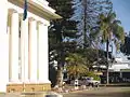 Bulawayo City Hall
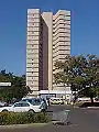 Kenilworth Towers, residential flats
Suburbs
| No | Suburb/location | Origin of name |
|---|---|---|
| 1 | Ascot | Adjoining the Bulawayo Ascot race-course |
| 2 | Barbourfields | The suburb was named after a former mayor, H. R. Barbour, who during the colonial era was greatly interested in the welfare of the indigenous people.[10] There is a place called Barbour in Argyll & Bute. Barbour is a Scottish family name, though it was apparently first recorded on the English side of the border, in Cumberland and Northumberland. The father of Scottish vernacular poetry, John Barbour (1320–1395), is best remembered for his epic poem "The Brus", telling the story of King Robert I. The origin of the name is occupational (a cutter of hair as well as an extractor of teeth during the Middle Ages). |
| 3 | Barham Green | The suburb was named after two people. The first was a former Bulawayo City Councillor (who later became an Alderman) Mrs. M. E. Barham, M.B.E. and the other was Rev. Rufus Green. They were critical in the establishment of this suburb. During the colonial Rhodesia era, it was designated for the Coloured community. |
| 4 | Beacon Hill | Also known as Beryl Drive, reference is made to fact that it is the high point of the suburbs and possesses the areas with the highest marking beacon at its summit. |
| 5 | Bellevue | The suburb was named after the estate name. It is sometimes spelled Belle Vue, and derives from the French meaning "beautiful view". |
| 6 | Belmont | |
| 7 | Belmont Industrial Area | The area was named after a former Bulawayo City Engineer, Mr. Kinmont. |
| 8 | Bradfield | The suburb was named after Edwin Eugene Bradfield, a pioneer. |
| 9 | Burnside | This area used to be a portion of former town council area and used to be part of Matsheumhlope Farms. The name is derived from the reference to the River Matsheumhlophe. "Burn" is a Scottish and northern English word for a stream. |
| 10 | Cement | This was named after the surrounding industrial area, responsible for the making of cement. |
| 11 | Cowdray Park | |
| 12 | Donnington | |
| 13 | Donnington West | |
| 14 | Douglasdale | The Douglas family, descendants of William de Douglas (late 12th century), was one of the most powerful in Scotland. |
| 15 | Eloana | |
| 16 | Emakhandeni | Emakhandeni is the Ndebele name for Fort Rixon, which was the area where the regiment Makhanda were located. Makhandeni is the locative term. |
| 17 | Emganwini | Reference is made to the plentiful amarula trees in the vicinity. |
| 18 | Enqameni | |
| 19 | Enqotsheni | |
| 20 | Entumbane | This is where King Mzilikazi was buried. It is one of the dozens of high-density suburbs of Bulawayo, commonly referred to as the "Western Suburbs". The first disturbances that led to the Gukurahundi were sparked in Entumbane, hence the term "Impi ye Ntumbane" that refers to the disturbances. |
| 21 | Fagadola | |
| 22 | Famona | The suburb was named after Famona, one of the daughters of King Lobengula. It means jealousy or envy must end (literally, "die"). |
| 23 | Fortunes Gate (including Mtaba Moya) | The suburb's name comes from the original property name, and the gates are those of the original market building. |
| 24 | Four Winds | The suburb name comes from the original property name; the first house was on top of a hill. |
| 25 | Glencoe | This name is etched into the Scottish psyche as the bleak glen in the Highlands where, in 1692, a party of MacDonald men, women, and children were treacherously massacred by the Campbells, who were acting under government orders. |
| 26 | Glengary | The suburb was named after its estate name. |
| 27 | Glenville (including Richmond South) | The suburb was named after its estate name. |
| 28 | Granite Park | |
| 29 | Greenhill | The suburb's name is a reference to scenery and topography. |
| 30 | Gwabalanda | Named after a Ndebele chief, Gwabalanda Mathe. |
| 31 | Harrisvale | |
| 32 | Helenvale | |
| 33 | Highmount | |
| 34 | Hillcrest | The suburb's name comes from the reference to topography. It is Greenhill's crest. |
| 35 | Hillside | The suburb's name is a reference to topography (Greenhill's slope). |
| 36 | Hillside South | The suburb's name comes from its position as the south facing slope of Greenhill. |
| 37 | Hume Park | "Hume"/"Home" is a Lowland Scottish family name. |
| 38 | Hyde Park | The name originates from the large number of residents who trace their ancestry to England. |
| 39 | Ilanda | Ndebele name for the egret |
| 40 | Iminyela | This is the name of a type of tree common in the area. |
| 41 | Intini | The name was given as a commemoration to the Mhlanga family, who originally set out with the Khumalo family under Mzilikazi as gratitude to their contribution to the Ndebele Kingdom, Mthwakazi. The Ntini is the totem of the Mhlanga-Mabuya clan. |
| 42 | Jacaranda | This is a reference to the jacaranda trees. |
| 43 | Kelvin (Industrial area, includes North East and West) | The area was named in reference to a suburb of Glasgow. It takes its name from the River Kelvin, a tributary of the River Clyde. |
| 44 | Kenilworth | The suburb was named after its estate name. |
| 45 | Khumalo | The suburb was named after the Royal Clan of the Matabele. The Khumalo hockey stadium is here. |
| 46 | Khumalo North | This is a reference to the position of Kumalo suburb. |
| 47 | Kilallo | |
| 48 | Killarney | |
| 49 | Kingsdale | |
| 50 | Lakeside | Lakeside is the stretch of water at the junction of the Old Essexvale Road and the road to the suburb of Waterford, and then on to Hope Fountain Mission. |
| 51 | Lobengula | It is named after the second and last Matabele King, Lobengula. |
| 52 | Lobenvale | The suburb's name is derived from a combination of King Lobengula's name and Umguza Valley. |
| 53 | Lochview | The suburb's name is in reference to Lakeside Dam and is famous in the city for its large Scottish residents and the Scottish style houses. According to the Bulawayo City Suburb Names website, the suburb was named in reference to Lakeside Dam. |
| 54 | Luveve | Named after Ndebele chief Luveve; established in 1935 |
| 55 | Mabuthweni | The suburb's name means "where the soldiers are"; the name was given in reference to a bachelors' quarters. |
| 56 | Magwegwe | The suburb name is named after Magwegwe, who was one of the significant people in King Lobengula's royal Bulawayo town. |
| 57 | Magwegwe North | This is a reference to the position relative to that of Magwegwe. |
| 58 | Magwegwe West | This is a reference to the position relative to that of Magwegwe. |
| 59 | Mahatshula | Mahatshula is named after one of the Ndebele Indunas, Mahatshula Ndiweni. |
| 60 | Makokoba | The suburb got its name from the actions of Mr. Fallon, who used walk around with a stick. The name comes from the word "umakhokhoba" which was how the locals referred to Fallon, meaning "the little old man who walks with a stick". The word actually describes the noise of the stick on the ground, ko-ko-ko, or the doors. It is the oldest African dwelling in the city. Political activism was rife in the pre-ZAPU era. |
| 61 | Malindela | The suburb was named after the mother of Faluta, who was the mother of Lobengula, i.e., after Lobengula's maternal grandmother. |
| 62 | Manningdale | It is named after the developer of the suburb. |
| 63 | Marlands | |
| 64 | Matsheumhlope | The name comes from the association with the river ("White Stones"). White stones in Ndebele and Zulu proper languages are "amatshe amhlope". |
| 65 | Matshobana | The suburb was named after Matshobana, who was a chief of the Khumalo clan and more significantly he was the father of Mzilikazi, the founder of the Ndebele Kingdom. |
| 66 | Montgomery | It is named after Bernard Montgomery, 1st Viscount Montgomery of Alamein, a decorated British Army commander. |
| 67 | Montrose | The suburb was named by the estate developers, and street names are of many Cotswolds villages and towns. |
| 68 | Morningside | |
| 69 | Mpopoma | The name comes from a descriptive Ndebele name for the area, which was derived from the sound the Mpopoma River makes when flowing. |
| 70 | Munda | The Tonga name for a plot of land on which people would farm |
| 71 | Mzilikazi | The suburb was named after the founder of uMthwakazi, King Mzilikazi. It is a stone's throw away from Barbourfields suburb, separated by a road called Ambulance Drive that leads to one of the city's largest hospitals, Mpilo. |
| 72 | New Luveve | Reference is made to the suburb Luveve; see Luveve suburb. |
| 73 | Newsmansford | |
| 74 | Newton | Estate name |
| 75 | Newton West | Reference to position (Newton) |
| 76 | Nguboyenja | Named after Lobengula's son and heir |
| 77 | Njube | Named after one of Lobengula's sons |
| 78 | Nketa | It is named after the traditional heritage site of Nketa Hill on which King Lobengula assembled his entire kingdom and in the spirit of nation building, chose a Kalanga wife, MaDumane or Ma Mlalazi and married her. This was against the advise from his Khumalo or Zansi advisers. He then told them that the Kalanga where more than the Khumalos, Ngunis and other clans who came from south of the Limpopo. He stated that it was then important that the broader Mthwakazi society must be inclussive of everyone and it was high time the Kalanga had a Queen from their own clan. At that stage Mthwakazi was divided into 3 subgroups : the Zansi - the people that Mzilikazi left Kwazulu with, mostly the Khumalo and Ndwandwe clans, : the Enhla - mostly Swazi, Ndebele (Mabhena, Mahlangu etc) and Sotho (Sibanda/Batau, Ngwenya/Bakwena etc) tribes from central Transvaal in South Africa and : the Hole - these were the Kalanga and Lozwi (Moyo, Tshuma, Nleya etc) people Mzilikazi found in this area. The division was done mostly for security reasons and the Khumalo royal family had to maintain that to ensure they preserve royalty. |
| 79 | Nkulumane | One of the sons of King Mzilikazi and heir, founder of the Matebele kingdom |
| 80 | North End | Reference to the direction of the suburb |
| 81 | North Lynne | |
| 82 | North Trenance | Reference to position relative to that of Trenance |
| 83 | Northlea | |
| 84 | Northvale | Former town council area; reference to position and (Umguza) valley |
| 85 | Ntaba Moyo | |
| 86 | Orange Grove | |
| 87 | Paddonhurst | Named after Major Cecil Paddon, O.B.E. (pioneer) |
| 88 | Parklands | Estate name; Park Lands estate A (portion of original grant to Dominican Sisters) |
| 89 | Parkview | Situated on the location adjacent to the Centenary Park and proposed location of Bulawayo Zoo |
| 90 | Phelandaba | Phelandaba translates as "the matter is concluded", a reference to the successful conclusion to the struggle for security. |
| 91 | Phumula | Phumula means "a resting place", reference to the fact that many have built homes there to retire to. |
| 92 | Phumula South | Named in reference to relative position of Pumula |
| 93 | Queens Park | A reference to the Queen and the three main roads – Victoria, Alexandra and Elizabeth |
| 94 | Queens Park East | A reference to the position relative to that of Queen Park |
| 95 | Queens Park West | A reference to the position relative to that of Queen Park |
| 96 | Queensdale | |
| 97 | Rangemore | The suburb adopted the original estate name. |
| 98 | Raylton | The suburb adopted the original estate name. |
| 99 | Richmond | |
| 100 | Riverside | Derived from the original estate name, which was in reference to the Umguza River |
| 101 | Romney Park | The suburb was named after George Romney, a British painter. |
| 102 | Sauerstown | Named after Dr. Han Sauer the owner of the land. |
| 103 | Selbourne Park | Named after the main road of Selbourne Avenue, now called L. Takawira Avenue, facing Ascot Mansions |
| 104 | Sizinda | Battle regiment of Mzilikazi of the Matabele |
| 105 | Southdale | |
| 106 | Souththwold | The suburb was named by the estate developers, and street names are of many Cotswolds villages and towns. |
| 107 | Steeldale | Composite name referring to industry |
| 108 | Suburbs | This was the first suburb in Bulawayo and retained that name. The suburb has many tree-lined avenues and is where the Centenary Park, Natural History Museum and the Bulawayo Athletic Club are found. |
| 109 | Sunninghill | After British royal residence (given to present Queen at time of marriage) |
| 110 | Sunnyside | Chosen from list of suggested names |
| 111 | Tegela | The name is derived from a Ndebele word ukwethekela meaning "to visit". |
| 112 | The Jungle | |
| 113 | Thorngrove | The suburb's name came from the large number of mimosa (thorn) trees in the area. |
| 114 | Trenance | |
| 115 | Tshabalala | This is the "isibongo" or praise name for Lobengula's mother, Fulata, who was of Swazi extraction. |
| 116 | Tshabalala Extension | Extension in reference to the suburb of Tshabalala |
| 117 | Umguza Estate | Named after the Umguza River which runs through it |
| 118 | Upper Rangemore | Name in reference to Rangemore suburb |
| 119 | Waterford | |
| 120 | Waterlea | |
| 121 | West Somerton | |
| 122 | Westgate | |
| 123 | Westondale | |
| 124 | Willsgrove | |
| 125 | Windsor Park | Named after English town or Guildford Castle grounds |
| 126 | Woodlands | Chosen from a list of suggested names |
| 127 | Woodville | |
| 128 | Woodville Park |
Topography
The city sits on a plain that marks the Highveld of Zimbabwe and is close to the watershed between the Zambezi and Limpopo drainage basins. The land slopes gently downwards to the north and northwest. The southern side is hillier, and the land becomes more broken in the direction of the Matobo Hills to the south.
Climate
Due to its relatively high altitude, the city has a humid subtropical climate despite lying in the tropics. Under the Köppen climate classification, Bulawayo features a semiarid climate (BSh). The mean annual temperature is 19.16 °C (66.49 °F),[13] similar to Pretoria at a similar altitude but almost 600 km (373 mi) further south. As with much of southern and eastern Zimbabwe, Bulawayo is cooled by a prevailing southeasterly airflow most of the year and experiences three broad seasons: a dry, cool winter season from May to August; a hot dry period in early summer from late August to early November; and a warm wet period in the rest of the summer, early November to April.
The hottest month is October, which is usually the height of the dry season. The average maximum temperature ranges from 21 °C (70 °F) in July to 30 °C (86 °F) in October. During the rainy season, daytime maxima are around 26 °C (79 °F). Nights are always cool, ranging from 8 °C (46 °F) in July to 16 °C (61 °F) in January.
The city's average annual rainfall is 594 mm (23 3⁄8 in), which supports a natural vegetation of open woodland, dominated by Combretum and Terminalia trees. Most rain falls in the December to February period, while June to August is usually rainless. Being close to the Kalahari Desert, Bulawayo is vulnerable to droughts and rainfall tends to vary sharply from one year to another. In 1978, 888 mm (35 in) of rain fell in the three months up to February (February 1944 is the wettest month on record with 368mm) while in the three months ending February 1983, only 84 mm (3 1⁄4 in) fell.
| Climate data for Bulawayo | |||||||||||||
|---|---|---|---|---|---|---|---|---|---|---|---|---|---|
| Month | Jan | Feb | Mar | Apr | May | Jun | Jul | Aug | Sep | Oct | Nov | Dec | Year |
| Record high °C (°F) | 36.7 (98.1) |
34.4 (93.9) |
35.6 (96.1) |
33.0 (91.4) |
30.6 (87.1) |
28.3 (82.9) |
28.3 (82.9) |
32.2 (90.0) |
35.0 (95.0) |
36.7 (98.1) |
37.2 (99.0) |
35.2 (95.4) |
37.2 (99.0) |
| Average high °C (°F) | 27.7 (81.9) |
27.2 (81.0) |
27.1 (80.8) |
25.9 (78.6) |
24.1 (75.4) |
21.6 (70.9) |
21.5 (70.7) |
24.4 (75.9) |
27.9 (82.2) |
29.4 (84.9) |
28.7 (83.7) |
27.7 (81.9) |
26.1 (79.0) |
| Daily mean °C (°F) | 21.8 (71.2) |
21.2 (70.2) |
20.6 (69.1) |
18.7 (65.7) |
16.0 (60.8) |
13.7 (56.7) |
13.8 (56.8) |
16.4 (61.5) |
19.9 (67.8) |
21.6 (70.9) |
21.7 (71.1) |
21.4 (70.5) |
18.9 (66.0) |
| Average low °C (°F) | 16.5 (61.7) |
16.2 (61.2) |
15.3 (59.5) |
13.0 (55.4) |
9.9 (49.8) |
7.4 (45.3) |
7.2 (45.0) |
9.1 (48.4) |
12.4 (54.3) |
15.0 (59.0) |
16.0 (60.8) |
16.3 (61.3) |
12.9 (55.2) |
| Record low °C (°F) | 10.0 (50.0) |
9.4 (48.9) |
8.4 (47.1) |
3.5 (38.3) |
0.0 (32.0) |
−3.9 (25.0) |
0.0 (32.0) |
0.0 (32.0) |
1.4 (34.5) |
6.9 (44.4) |
7.2 (45.0) |
8.9 (48.0) |
−3.9 (25.0) |
| Average rainfall mm (inches) | 117.8 (4.64) |
104.6 (4.12) |
51.4 (2.02) |
33.3 (1.31) |
7.0 (0.28) |
2.2 (0.09) |
1.0 (0.04) |
1.4 (0.06) |
7.0 (0.28) |
38.4 (1.51) |
91.1 (3.59) |
120.3 (4.74) |
575.5 (22.66) |
| Average rainy days | 10 | 8 | 5 | 3 | 1 | 1 | 0 | 0 | 1 | 4 | 8 | 10 | 51 |
| Average relative humidity (%) | 69 | 71 | 70 | 62 | 56 | 54 | 48 | 43 | 41 | 43 | 55 | 63 | 56 |
| Mean monthly sunshine hours | 244.9 | 212.8 | 251.1 | 252.0 | 279.0 | 267.0 | 288.3 | 300.7 | 288.0 | 272.8 | 237.0 | 226.3 | 3,119.9 |
| Mean daily sunshine hours | 7.9 | 7.6 | 8.1 | 8.4 | 9.0 | 8.9 | 9.3 | 9.7 | 9.6 | 8.8 | 7.9 | 7.3 | 8.5 |
| Source 1: World Meteorological Organization[14] NOAA (sun and mean temperature, 1961–1990)[15] | |||||||||||||
| Source 2: Deutscher Wetterdienst (extremes and humidity)[16] | |||||||||||||
Water supply
Bulawayo has good-quality tap water owing to the management of the water authorities, meeting international standards. Bulawayo does not recycle waste water but uses treated waste water for irrigation.
Bulawayo experiences water shortages in drought seasons due to the overwhelming increase in population versus the static and sometimes decreasing capacity of the reserve dams. The geographical factors causing water scarcity are rising temperatures, the area's high elevation and the arid environment of Matabeleland. Bulawayo provides residents with water by using a system of dams, treatment plants, and reservoirs.
Environmental and sanitation circumstances have detrimental effects on water quality. Sources such as groundwater and tap water are subject to pollution due to waste from burst sewers contaminating them. Samples taken from well water from the Pumula and Robert Sinyoka suburbs show that well water maintain levels of coliform higher than the Standards Association of Zimbabwe and World Health Organization give.[17][18]
Demographics
Population census controversy
| Year | Pop. | ±% |
|---|---|---|
| 1982 | 413,814 | — |
| 1992 | 620,936 | +50.1% |
| 2002 | 676,650 | +9.0% |
| 2012 | 653,337 | −3.4% |
| Source: Zimbabwe National Statistics Agency (ZIMSTAT) | ||
The population of Bulawayo, according to the 2012 national census, stood at 653,337;[19] however, this figure has been rejected by the Bulawayo City Council authority with Councillor Martin Moyo claiming an anti-Bulawayo conspiracy to under-fund projects in the city.[20][21]
The population of the city according to metropolitan council sources is closer to 1.5 million and a more closer and estimated figure being 1.2 million. Reports have alluded to the de-industrialization of the city as the reason for its population decline, a claim which was rubbished as council officials referred to the fact that, in 1992 the city's population stood at 620,936. It had grown in the number of households due to urban expansion. City authorities also laid claim to the fact that the current water challenges facing the city were a result of an increasing population despite its economic challenges.
Ethnic groups
The vast majority of Bulawayo City residents were Black African with 97.96%. Other ethnic groups in the city were Coloured (0.9%), White (0.75%), Asian (0.22%). Members of other ethnic groups comprised 0.02%, and 0.14% of the city did not state their ethnic group.
Economy
Bulawayo was known as the industrial hub of Zimbabwe. This has led to the Zimbabwe International Trade Fair being hosted in Bulawayo. It had a large manufacturing presence with large industries based here before Zimbabwe's economic decline. However, some of these companies have either moved operations to Harare or have closed down — which has crippled Bulawayo's economy. Most factories are deserted and the infrastructure has since been left to deteriorate. The reason for the de-industrialization has largely been political, with some factories like Goldstar Sugars removing machinery to open new factories in Harare. When the Zimbabwean government passed indigenisation laws, some successful businesses were taken over by ZANU-PF supporters, only to close down a fews years later.
Many locals argue that it is because of marginalisation they experience against the government due to political tensions with the ZANU PF government in Harare and the MDC run Bulawayo council, for instance, the National railways of Zimbabwe (headquarters in Bulawayo) is a government owned entity and, as such, should have been thriving had it not been for embezzlement of funds by company executives who are believed to be Shona. The water issue is not new and had brought about the "help a thirsty Matabele" initiative of the 1970s and the Matabeleland Zambezi Water Project which would put an end to the water issue in Matabeleland was drafted; however, this project was put on hold soon after independence.[22]
These allegations have all been refuted by national authorities. The city still contains the bulk of Zimbabwe's heavy industry and food processing capability. This includes a thermal power station that resumed operations in February 2011 after a capitalisation deal with the Government of Botswana where Bulawayo would supply 45 megawatts in three years.
Like many parts of the country, Bulawayo has for the past ten years seen a huge drop in service delivery and an increase in unemployment, with many who can opting to seek better prospects abroad. Many people resorted to farming, mining, and the black market for sustenance, while others depended on the little foreign currency that would be sent by family in other countries. However, with inauguration of the Mnangagwa government, a new approach is seen by investors in the city who admire the already-available infrastructure; the huge workforce; and Bulawayo as a potential business hub.[23] It is set to once again contribute greatly to the economy of Zimbabwe.
The city is served by Joshua Mqabuko Nkomo International Airport and the other international airport in the region being the Victoria Falls International Airport. Matabeleland boosts of Victoria Falls, Matopo National Park, Hwange National Park, Khami Ruins and a bigger share of Lake Kariba. The city is located within an excellent road and rail transport network linking the region to South Africa, Botswana, Zambia and Mozambique.
Important buildings and infrastructure
These include:
- Ascot Centre
- Bulawayo Centre
- Bulawayo Golf Club
- Fidelity Life Centre
- Mhlahlandlela Government Complex
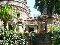
- Nesbitt Castle
- NRZ building
- National University of Science and Technology
Government
Bulawayo is governed by the Bulawayo City Council, which is headed by the Mayor of Bulawayo.
Bulawayo City Council
Controlled by the main opposition party MDC-T, the council has managed to stand out as the leading municipality in Zimbabwe in service delivery to its residents, through campaigns engineered by the city council such as the #mycitymypride campaign and #keepbyoclean on social media. These have been met with positive responses by residents and other stakeholders in the city. In recent years, Bulawayo has been widely perceived as the cleanest city in Zimbabwe due to the council's effective waste management strategy.
In 2015 the city of Bulawayo was praised for its town planning that, unlike other major urban areas has not been marred by corruption and problems such as illegal settlements.
Culture
Museums
Bulawayo has museums of national importance, including the Natural History Museum of Zimbabwe, National Gallery, Bulawayo and the Bulawayo Railway Museum.
Parks
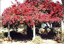
There are a number of parks in Bulawayo, including
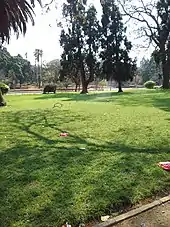
- Centenary Park (which iancludes an amphitheatre, lawns and a large fountain)
- Barham Green
- Hillside Dams Conservancy (which has a number of dams within it)
- Mabukweni
Geography
Bulawayo is located in the south west of Zimbabwe. It is in the middle of the savanna country. It has 4 seasons with rains starting in late October to about March. Coldest months being May and June with July being cold and windy.[24]
Sports
Bulawayo is home to the Queens Sports Club and Bulawayo Athletic Club, two of the three grounds in Zimbabwe where test match cricket has been played.
Bulawayo Golf Club, the first golf club in the city and country was established in 1895. The Matsheumhlope Stream cuts through the 18 hole course in the suburbs.
It is home to Hartsfield Rugby grounds where many international Test matches have been played. Hartsfield was developed by Reg Hart, after whom the grounds were named and on which field many of southern Africa's greatest rugby players have competed. It is home to two large football teams: Highlanders and Zimbabwe Saints. Other football teams include Bantu Rovers, Chicken Inn, How Mine, Quelaton, and Bulawayo City (R).
Other important sporting and recreational facilities include
- Barbourfields Stadium
- Zimbabwe International Trade Fair Grounds
- Kumalo Hockey Stadium
- Ascot Racecourse
- Khami Ruins
- White City Stadium
- Karate centres
Infrastructure
Transport
The city has a total road network of about 2,100 kilometres; 70 percent was declared in 2017 in a poor condition.[25] The R2 road links Bulawayo with the Capital Harare, and the Cape to Cairo Road links with the Gaborone and Lusaka.
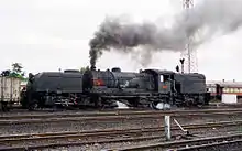
The Bulawayo railway station is the central point of the railway line that connects the cities of Lusaka and Gaborone (part of the Cape to Cairo Railway), as well as being the terminal of the Beira–Bulawayo railway, which connects with the cities of Gweru, Harare, Mutare and Beira.[26] Through the station in the outskirts of Umzingwane, the city of Bulawayo is connected to the Beitbridge Bulawayo Railway.
On the 1 November 2013, a new terminal of Joshua Mqabuko Nkomo International Airport, formerly known as Bulawayo Airport, was opened.[27]
Healthcare
Bulawayo is home to a large number of hospitals and other medical facilities. The United Bulawayo Hospitals, a public hospital network, operates Bulawayo Central Hospital, Richard Morris Hospital, Lady Rodwell Maternity Hospital, and Robbie Gibson Infectious Diseases Hospital.[28] Mpilo Central Hospital, is the largest hospital in Bulawayo, and the second-largest in Zimbabwe, and features a nursing school and midwifery school on its campus. Bulawayo is also home to Ingutsheni Hospital, which at 700 beds is the largest psychiatric hospital in Zimbabwe. Other hospitals in Bulawayo include All Saints Children's Hospital, Hillside Hospital, Mater Dei Hospital, the Nervous Disorders Hospital, St Francis Hospital and Thorngrove Isolation Hospital.
Education
In Bulawayo, there are 128 primary and 48 secondary schools.[29]
Primary schools
| No. | School Name |
|---|---|
| 1. | Amaswazi Primary School |
| 2. | Amaveni Primary School |
| 3. | Babambeni Primary School |
| 4. | Baines Infant School |
| 5. | Baines Junior |
| 6. | Barham Green Primary School |
| 7. | Carmel Primary School |
| 8. | Coghlan Primary School |
| 9. | Dominican Convent Primary School, Bulawayo |
| 10. | Dumezweni Primary School |
| 11. | Emakhandeni Primary School |
| 12. | Fairbridge Primary School |
| 13. | Fusi Primary School |
| 14. | Gampu Primary School |
| 15. | Godlwayo Primary School |
| 16. | Helemu Primary School |
| 17. | Henry Low Primary School |
| 18. | Hillside Infant School |
| 19. | Hillside Junior School |
| 20. | HQ 1 Brigade Primary School |
| 21. | Hugh Beadle Primary School |
| 22. | Induba Primary School |
| 23. | Infant School |
| 24. | Ingubo Primary School |
| 25. | Ingwegwe Primary School |
| 26. | Inkanyezi Primary School |
| 27. | Insukamini Primary School |
| 28. | Intunta Primary School |
| 29. | Inzwananzi Primary School |
| 30. | John Slaven Primary School |
| 31. | Josiah Chinamano Primary School |
| 32. | King George VI Memorial School |
| 33. | Kumalo Primary School |
| 34. | Lobengula Primary School |
| 35. | Lobengula Primary School |
| 36. | Lochview Primary School |
| 37. | Losikeyi Primary School |
| 38. | Lotshe Primary School |
| 39. | Lukhanyiso Primary School |
| 40. | Luveve Primary School |
| 41. | Mabhukudwana Primary School |
| 42. | Mafakela Primary School |
| 43. | Mafela Primary School |
| 44. | Magwegwe Primary School |
| 45. | Mahlabezulu Primary School |
| 46. | Mahlathini Primary School |
| 47. | Malindela Primary School |
| 48. | Manondwana Primary School |
| 49. | Manyewu Primary School |
| 50. | Maphisa Primary School |
| 12. | Masiyephambili Junior School |
| 51. | Masuku Primary School |
| 52. | Maswazi Primary School |
| 53. | Matshayisikova Primary School |
| 54. | Mawaba Primary School |
| 55. | Mazwi Primary School |
| 56. | Mbizo Primary School |
| 57. | McKeurten Primary School |
| 58. | Mganwini Primary School |
| 59. | Mgiqika Primary School |
| 60. | Mgombane Primary School |
| 61. | Mhali Primary School |
| 62. | Milton Junior School |
| 63. | Mkhithika Primary School |
| 64. | Moray Primary School |
| 65. | Mpumelelo Primary School |
| 66. | Mthombowesizwe Primary School |
| 67. | Mtshane Primary School |
| 68. | Mtshede Primary School |
| 69. | Mtshingwe Primary School |
| 70. | Mzilikazi Primary School |
| 71. | Newmansford Primary School |
| 72. | Ngwalongwalo Primary School |
| 73. | Nketa Primary School |
| 74. | Nkulumane Primary School |
| 75. | Ntabeni Primary School |
| 76. | Ntshamathe Primary School |
| 77. | Nyamande Primary School |
| 78. | Petra Primary School |
| 79. | Phelandaba SDA Primary School |
| 80. | Queen Elizabeth II Primary School |
| 81. | Rangemore Primary School |
| 82. | Robert Tradgold Primary School |
| 83. | Rose Camp Primary School |
| 84. | Senzangakhona Primary School |
| 86. | Sigombe Primary School |
| 87. | St. Bernards R.C Primary School |
| 88. | St. Patricks R.C Primary School |
| 89. | St. Thomas Aquinas Primary School |
| 90. | Tategulu Primary School |
| 91. | Tennyson Primary School |
| 92. | Thembiso Primary School |
| 93. | Thomas Rudland Primary School |
| 94. | Trenance Primary School |
| 95. | Waterford Primary School |
| 96. | Whitestone School |
| 97. | Woodville Primary School |
| 98. | Zulukandaba Primary School |
Secondary and high schools
Schools outside Bulawayo
- Falcon College – Esigodini
- Plumtree School – Plumtree
- Mzingwane High School - Esigodini
- St. James Girls High School - Nyamandlovu
- Rhodes Estate Preparatory School - Matopo
- George Silundika High School - Nyamandlovu
Higher education
Bulawayo is home to a number of colleges and universities. The National University of Science and Technology, Zimbabwe, (NUST), the second largest university in Zimbabwe, was established in Bulawayo in 1991.[30] Solusi University, a Seventh-day Adventist institution established in Bulawayo in 1894, gained university status in 1994.
The Bulawayo Polytechnic College offers tertiary training for students who have completed GCE O Level and A Level education. It issues national certificates NC, Diplomas and higher national diplomas HND certificates. Bulawayo has two specialist teacher training colleges : Hillside Teachers College for secondary education and the United College of Education for primary education.
Bulawayo is home to a number of institutes of technology and vocational colleges, including Zimbabwe School of Mines, Westgate Industrial Training College, and the Zimbabwe Theological College. In addition companies such as the National Railways of Zimbabwe NRZ and Zimbabwe Electricity and Supply Authority ZESA offer apprenticeship training for qualifying students who then become certified artisans upon completion.
Media
Newspapers
The Chronicle, a state-owned daily newspaper, and its Sunday edition, The Sunday News, are published in Bulawayo. The Chronicle is the second-oldest newspaper in Zimbabwe, and along with The Herald, published in Harare, it is one of two major state-owned newspapers in the country. UMthunywa, a state-owned Ndebele-language newspaper, is also published in Bulawayo, where the majority of the population belongs to the Ndebele people. Private online publications like Bulawayo24 News and B-Metro are also based in Bulawayo.
Radio
The two radio stations, Skyz Metro FM, which is the first dedicated commercial radio station for the city and Khulumani FM, owned by the Zimbabwe Broadcasting Corporation are based in the city and offer their programming mainly in English and Ndebele and other languages spoken in the Matabeleland region. The other 6 radio stations, in which only two of those are privately owned, are also accessible in the city via FM transmission.
Television
The state owned ZBC TV is the only free to air TV channel in the city. The majority of the households rely on the South African based satellite television distributor, DStv and OVHD for better entertainment, news and sport across Africa and the world.
Internet
There are a number of internet service providers in the city. The majority of the population in the city access the internet through their mobile phones mainly for news, entertainment and communication.
Notable people
International relations
Bulawayo has six sister cities:
See also
- List of cities and towns in Zimbabwe
References
- Google Earth
- "Sub-national HDI - Area Database - Global Data Lab". hdi.globaldatalab.org. Retrieved 13 September 2018.
- "Bulawayo". Collins Dictionary. Retrieved 24 May 2019.
- A.R.C.B. (1961). "Review: A Russian Look at Rhodesia". The Journal of African History. 2 (1): 161–162. doi:10.1017/s0021853700002279.
- Thorpe, C. Limpopo to Zambesi, London, 1951, p.51
- "D.S.O." London Gazette. 19 April 1901. Retrieved 24 November 2013.
- Britannica, Bulawayo, britannica.com, USA, accessed on July 7, 2019
- "Industrial empire Bulawayo reduced to a ghost town". mg.co.za. Retrieved 30 July 2014.
- "isiNdebele for beginners. Northern Ndebele language in Africa". www.northernndebele.blogspot.com.
- "Scottish Place Names - Bulawayo, Zimbabwe". www.rampantscotland.com. Retrieved 10 April 2019.
- Technologies, Numo Uno. "Bulawayo 1872.com :::: Southern African home". www.bulawayo1872.com.
- "Scottish Place Names - Bulawayo, Zimbabwe". www.rampantscotland.com.
- GISS Climate data, Average annual temperature 1971 to 2001
- "World Weather Information Service – Bulawayo". World Meteorological Organization. Retrieved 25 October 2015.
- "Bulawayo Airport Climate Normals 1961–1990". National Oceanic and Atmospheric Administration. Retrieved 10 June 2016.
- "Klimatafel von Bulawayo (Goetz-Observatorium) / Simbabwe" (PDF). Baseline climate means (1961–1990) from stations all over the world (in German). Deutscher Wetterdienst. Retrieved 13 May 2016.
- Nyemba, Anesu; Manzungu, Emmanuel (2010). "The impact of water scarcity on environmental health in selected residential areas in Bulawayo City, Zimbabwe". Physics and Chemistry of the Earth, Parts A/B/C. 35 (13–14): 823–827. Bibcode:2010PCE....35..823N. doi:10.1016/j.pce.2010.07.028.
- Nyemba, Anesu. "The impact of water scarcity on environmental health in selected residential areas in Bulawayo City, Zimbabwe." Physics and chemistry of the earth 35.13 (2010):823–827. Web.
- "Provincial Report – Bulawayo" (PDF). Archived from the original (PDF) on 9 September 2015. Retrieved 4 May 2016.
- "Bulawayo Census Outrage". chronicle.co.zw. Retrieved 4 May 2016.
- "Storm Over Bulawayo Census Results". thestandard.co.zw. Retrieved 4 May 2016.
- https://www.state.gov/reports/2019-investment-climate-statements/zimbabwe/#:~:text=Zimbabwe%20has%20attracted%20low%20investment,USD%20470%20million%20in%202018.
- https://www.state.gov/reports/2019-investment-climate-statements/zimbabwe/#:~:text=Zimbabwe%20has%20attracted%20low%20investment,USD%20470%20million%20in%202018.
- Zimbabwe, britannica.com, USA, accessed on July 7, 2019
- "70% of Bulawayo roads dilapidated". bulawayo24.com. 12 February 2017. Retrieved 17 May 2017.
- Mlambo, Alois (2003). "Bulawayo, Zimbabwe". In Paul Tiyambe Zeleza; Dickson Eyoh (eds.). Encyclopedia of Twentieth-Century African History. Routledge. ISBN 0415234794.
- "Joshua Mqabuko Nkomo International Airport opens". bulawayo24.com. 2 November 2013. Retrieved 17 May 2017.
- "About Us". United Bulawayo Hospitals. Retrieved 27 February 2019.
- Makoni, Albert (6 September 2007). "Health disaster looms in Bulawayo". The Zimbabwe Guardian. Archived from the original on 26 December 2007. Retrieved 22 November 2007.
- Shizha, Edward; Kariwo, Michael T. (2012). Education and Development in Zimbabwe. Springer Science & Business Media. p. 10. ISBN 9789460916069.
- "Twin City of Aberdeen Stavanger Norway". About Aberdeen. Retrieved 26 February 2019.
- "Sister Cities". www.durban.gov.za. Retrieved 26 February 2019.
- "Bulawayo Engages Australia For Economic Development". ZimEye. 2 December 2018. Retrieved 26 February 2019.
Bibliography
| Wikimedia Commons has media related to Bulawayo. |
| Wikivoyage has a travel guide for Bulawayo. |
| Authority control |
|---|