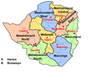
Provinces of Zimbabwe
Provinces are constituent political entities of Zimbabwe. Zimbabwe currently has ten provinces, two of which are cities with provincial status. Zimbabwe is a unitary state, and its provinces exercise only the powers that the central government chooses to delegate. Provinces are divided into districts, which are divided into wards.
| Provinces of Zimbabwe | |
|---|---|
 | |
| Category | Unitary state |
| Location | Republic of Zimbabwe |
| Number | 10 Provinces |
| Populations | 1,200,337 (Bulawayo) – 2,123,132 (Harare Province) |
| Areas | 1,710 km2 (659 sq mi) (Bulawayo) - 28,967 sq mi (75,025 km2) ( Matabeleland North) |
| Government | Provincal government, National government |
| Subdivisions | District |
 |
|---|
| This article is part of a series on the politics and government of Zimbabwe |
The Constitution of Zimbabwe delineates provincial governance and powers. After constitutional amendments in 1988, provinces were administered by a governor directly appointed by the President of Zimbabwe.[1] Since the 2013 constitutional changes, there are technically no longer provincial governors, though in practice they remain in place as Ministers of State for Provincial Affairs. The 2013 Constitution also calls for the devolution of governmental powers and responsibilities where appropriate, though Zimbabwean opposition parties argue that the central government has yet to comply.[2]
With the establishment of Company rule in Rhodesia in the 1890s, the country was divided into two provinces: Matabeleland in the west and Mashonaland in the east. Under British colonial rule as Southern Rhodesia, the colony was divided into five provinces. Later, the Rhodesian government expanded the number of provinces to seven: Manicaland, Matabeleland North and South, Mashonaland North and South, Midlands, and Victoria (today Masvingo).[3] In the 1980s, Mashonaland North and South became three provincesThe youngest provinces, Bulawayo and Harare, were created in 1997.
| Name | Towns and cities | Established 2020 | Population (2012) | Total area[4] | Location | ||
|---|---|---|---|---|---|---|---|
| Capital | Largest | km2 | mi2 | ||||
| Bulawayo | Bulawayo | 1997 | 1,200,337 | 900 | 347 | .svg.png.webp) | |
| Harare | Harare | 1997 | 2,123,132 | 872 | 337 | .svg.png.webp) | |
| Manicaland | Mutare | ? | 1,752,698 | 36,459 | 14,077 | 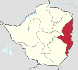 | |
| Mashonaland Central | Bindura | 1983 | 1,152,520 | 28,347 | 10,945 | 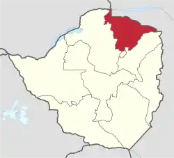 | |
| Mashonaland East | Marondera | ? | 1,344,955 | 12,444 | 7,732 | 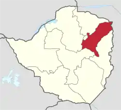 | |
| Mashonaland West | Chinhoyi | Kadoma | 1983 | 1,501,656 | 57,441 | 22,178 | 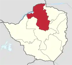 |
| Masvingo | Masvingo | ? | 1,485,090 | 56,566 | 21,840 | 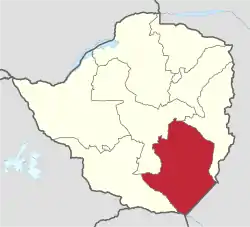 | |
| Matabeleland North | Lupane | Victoria Falls | 1973 | 749,017 | 75,025 | 28,967 | 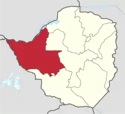 |
| Matabeleland South | Gwanda | Beitbridge | 1973 | 683,893 | 54,172 | 20,916 |  |
| Midlands | Gweru | ? | 1,614,941 | 49,166 | 18,983 | 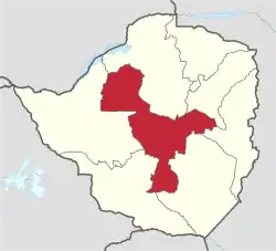 | |
See also
- Districts of Zimbabwe
- Municipalities of Zimbabwe
- List of provincial governors of Zimbabwe
- List of Zimbabwean provinces by population
- List of Zimbabwean provinces by Human Development Index
- List of Zimbabwean presidential election results by province
- ISO 3166-2:ZW
External links
References
- Bridger, Peter Anthony (1973). Encyclopaedia Rhodesia. College Press.
- Kandemiiri, Jonga (2016-03-01). "MDC-T Urges Zimbabwe to Devolve Power to Provinces". VOA. Retrieved 2018-07-25.
- Passmore, Gloria C. (1972). The National Policy of Community Development in Rhodesia. Department of Political Science, University of Rhodesia. p. 163.
- Zimbabwe at GeoHive
5.Zimbabwe census2012 https://www.citypopulation.de/Zimbabwe-Cities.html