Marsabit County
Marsabit County[2] (up to 2010 Marsabit District) is a county of Kenya. Covering a surface area of 66.923,1 square kilometres Marsabit is the largest county in Kenya. Its capital is Marsabit and its largest town Moyale. According to the 2019 census, the county has a population of 459,785.[3] It is bordered to the North by Ethiopia, to the West by Turkana County to the South by Samburu County and Isiolo County, and to the East by Wajir County.
Marsabit County | |
|---|---|
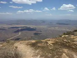 Marsabit Landscape | |
 Flag  Coat of arms | |
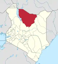 Location of Marsabit County in Kenya | |
| Coordinates: 2°19′N 37°58′E | |
| Country | |
| Formed | 4 March 2013 |
| Capital | Marsabit |
| Largest town | Moyale |
| Other towns | Sololo |
| Government | |
| • Governor | Mohammud Ali |
| Area | |
| • Total | 66,923.1 km2 (25,839.2 sq mi) |
| Population (2019)[1] | |
| • Total | 459,785 |
| • Density | 6.9/km2 (18/sq mi) |
| Time zone | UTC+3 (EAT) |
| Website | marsabit |
Geography
The county is located in central north Kenya. It borders the eastern shore of Lake Turkana. Important topographical features are: Ol Donyo Ranges (2,066m) in the southwest, Mount Marsabit (1,865m) in the central part of the county, Hurri Hills (1,685m) in the northeastern part of the county, Mount Kulal (2,235m) in the northwest and the mountains around Sololo-Moyale escarpment (up to 1,400m) in the northeast. The Chalbi Desert makes up much of the center region of the county.[4]
Physical and Tropical Features
The county is made of an extensive plain lying 300m and 900m above sea level which gently slopes towards the south east. Some of the prominent features include Ol Donyo (2,066m above sea level), Mt. Marsabit (1,865m above sea level), Hurri Hills (1,685m above sea level) Mt. Kulal (2,235m above sea level) and the Sololo-Moyale escarpment (up to 1,400m above sea level).
[5][6]
Climatic Conditions
The county experience semi-arid climatic conditions with an average temperature range between 15C – 26C and Annual rainfall ranges between 200mm and 1,000mm per annum. long start in April and May and short rain seasons from November and December.[7][6]
Demographics
The county has a total population of 459,785 of which 243,548 are males, 216,219 females and 18 intersex persons. There are 77,495 household with an average household size of 5.8 persons per household and a population density 6 people per square kilometre.[8]
Population
| Year | Pop. | ±% |
|---|---|---|
| 1979 | 96,216 | — |
| 1989 | 129,262 | +34.3% |
| 1999 | 174,957 | +35.4% |
| 2009 | 291,166 | +66.4% |
| 2019 | 459,785 | +57.9% |
| source:[9] | ||
| Urban Centre | 2019 Population[10] |
|---|---|
| Moyale | 37,387 |
| Marsabit | 14,907 |
| Sololo | 9,104 |
| Loiyangalani | 5,117 |
| Laisamis | 2,643 |
Administrative and Political Units
Administrative Units
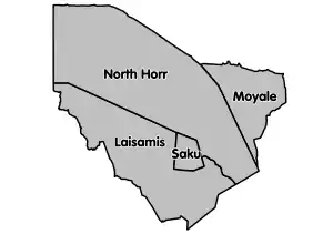
There are 4 sub counties, 16 divisions, 63 locations and 127 sub-locations.[11]
Sub-Counties
- Saku
- North Horr
- Laisamis
- Moyale
Electoral constituencies
There 4 constituencies and 20 county assembly wards.[12]
Political Leadership
Mohamed Mohamud Ali is the Governor and was elected in 2017 and his deputy is Solomon Gubo Riwe.[13][14] He replaced Ukur Yattani, the first governor of Marsabit county and currently the Cabinet Secretary of National Treasury & Planning.[15][16] Gordana Hargura is the Senator and has been senator since 2013.[17] Nasra Ibrahim Ibren is the first elected women representative and was replaced in 2017 general elections by Safia Sheikh Adan.[18][19]
For Marsabit County, the County Executive Committee comprises:-
| Number | |
|---|---|
| The Governor | 1 |
| The Deputy Governor | 1 |
| The County Secretary | 1 |
| The CEC Members | 10 |
| Total | 13 |
Source[20]
Members of Parliament 2017-2022 (Marsabit County)
- Hon. Wario, Qalicha Gufu[21] of Jubilee Party (JP) Member of Parliament Moyale Constituency.[22]
- Hon. Ganya, Francis Chachu[23] of Fap Party Member of Parliament North Horr Constituency.[24]
- Hon. Raso, Dido Ali[25] of Jubilee Party (JP) Member of Parliament Saku Constituency.[25]
- Hon. Arbelle, Marselino[26] of Jubilee Party (JP) Malimo Member of Parliament Laisamis Constituency.[27]
Education
There are 277 ECD centres 209 primary schools and 31 secondary schools. The county has also 1 teachers training colleges, 4 Youth Polytechnics, 106 adult training institutions and 6 technical training institutions.[28]
Health
There is a total of 111 health facilities, hospital beds in the county. County has 457 health personnel of different cadre.[29]
HIV prevalence is at 1% below the national 5.3% (Kenya HIV Estimates 2011).[30]
Transport and Communication
The county is covered by 5,000 Km of road network. of this 4,108 km is covered by earth surface, 580 km is murram surface and 312 km of surface is covered by Bitumen.[31][32]
There are two post office with 1,000 installed letter boxes, 717 rented letter boxes and 283 vacant letter boxes.[33]
Electoral constituencies
| Constituencies of Marsabit County[34] | ||||||
|---|---|---|---|---|---|---|
| Map | Constituency Name | Constituency No. | Approximate Population (2009) | Area in km2 | ||
 |
Moyale | 45 | 145,196 | 9,390 | ||
| North Horr | 46 | 109,179 | 38,953 | |||
| Saku | 47 | 46,502 | 2,078 | |||
| Laisamis | 48 | 65,669 | 20,266 | |||
| Total | 291,166 | 70,687 | ||||
Subdivisions
Marsabit County is divided into six administrative divisions:
| Division | Population* | Urban pop.* | Headquarters |
|---|---|---|---|
| Central | 25,100 | 10,619 | Marsabit |
| Gadamoji | 12,345 | 0 | |
| Laisamis | 24,011 | 2,817 | Laisamis |
| Loiyangalani | 16,965 | 1,054 | |
| Maikona | 55,518 | 20,100 | Maikona |
| North Horr | 68,539 | 30,343 | North Horr |
| Total | 202,298 | 97,677 | - |
| * 1999 census. Sources:,,[35][36] | |||
References
- "Kenya Census 2009 - Census - Kenya". Scribd. Retrieved 20 April 2018.
- "About Marsabit". County Government of Marsabit. Retrieved 28 May 2020.
- "2019 Kenya Population and Housing Census Volume I: Population by County and Sub-County". Kenya National Bureau of Statistics. Retrieved 6 November 2019.
- "About Marsabit". County Government of Marsabit. Retrieved 2 August 2019.
- "Marsbit County Integrated Development Plan CIDP 2018-2022". Council of Governors. 2018. Retrieved 30 May 2020.
- "Marsabit County". County Government of Marsabit. Retrieved 30 May 2020.
- envitech. "County Integrated Development Plans". Kenya Property Developers Association. Retrieved 30 May 2020.
- Munene, Evans (4 November 2019). "2019 Kenya Population and Housing Census Results". Kenya National Bureau of Statistics. Retrieved 30 May 2020.
- Kenya: Administrative Division population statistics
- "CIDP Marsabit 2018-2022". Maarifa Centre. Retrieved 11 November 2019.
- "Ministry of Interior and Coordination of National Government". Ministry of Interior and Coordination of National Government. Retrieved 30 May 2020.
- "The Report of the Interim Independent Boundaries Review Commission (IIBRC): Delimitation of Constituencies and Recommendations on Local Authority Electoral Units and Administrative Boundaries for Districts and Other Units" (PDF). IIBRC. 2010. Retrieved 30 May 2020.
- "Governors & Deputy Governors". cog.go.ke. Retrieved 30 May 2020.
- "Ali Mohamud Mohamed". Mzalendo. Retrieved 30 May 2020.
- "Ukur Yattani". Mzalendo. Retrieved 30 May 2020.
- "Amb.Ukur Yatani Kacho" (PDF). The National Treasury. 2020. Retrieved 30 May 2020.
- "Members of the Senate | The Kenyan Parliament Website". www.parliament.go.ke. Retrieved 30 May 2020.
- "Women Representatives | KEWOPA KENYA". Retrieved 30 May 2020.
- "Nasra Ibrahim Ibren". Mzalendo. Retrieved 30 May 2020.
- "The Report of the Interim Independent Boundaries Review Commission (IIBRC): Delimitation of Constituencies and Recommendations on Local Authority Electoral Units and Administrative Boundaries for Districts and Other Units" (PDF). IIBRC. Retrieved 30 May 2020.
- "Qalicha Gufu Wario". Mzalendo. Retrieved 30 May 2020.
- "Hon. Wario, Qalicha Gufu | The Kenyan Parliament Website". www.parliament.go.ke. Retrieved 30 May 2020.
- "Francis Chachu Ganya". Mzalendo. Retrieved 30 May 2020.
- "Hon. Ganya, Francis Chachu | The Kenyan Parliament Website". www.parliament.go.ke. Retrieved 30 May 2020.
- "Hon. Raso, Dido Ali | The Kenyan Parliament Website". www.parliament.go.ke. Retrieved 30 May 2020.
- "Marselino Malimo Arbelle". Mzalendo. Retrieved 30 May 2020.
- "Hon. Arbelle, Marselino Malimo | The Kenyan Parliament Website". www.parliament.go.ke. Retrieved 30 May 2020.
- "County Statistical Abstract Mandera County 2015". Kenya National Bureau of Statistics. 2015. Retrieved 30 May 2020.
- Mandera County Statistical Abstract 2015. Mandera County. 2015. pp. 28, 29.
- "National HIV Indicators for Kenya: 2011" (PDF). Ministry of Health. 2011. Retrieved 30 May 2020.
- "Kenya Rural Roads Authority". www.kerra.go.ke. Retrieved 30 May 2020.
- "Kenya Urban Roads Authority". kura.go.ke. Retrieved 30 May 2020.
- Marsbit County Statistical Abstract 2015. Kenya National Bureau of Statistics. 2015. p. 17.
- "Delimitation of Constituencies and Recommendations on Local Authority Electoral Units and Administrative Boundaries for Districts and Other Units". Independent Electoral and Boundaries Commission (IEBC). Retrieved 11 April 2019.
- "Archived copy" (PDF). Archived from the original (PDF) on 28 September 2007. Retrieved 26 November 2007.CS1 maint: archived copy as title (link)
- "Archived copy". Archived from the original on 28 September 2006. Retrieved 27 November 2007.CS1 maint: archived copy as title (link)
External links
- http://softkenya.com/county/marsabit-county/ Marsabit County
- http://www.aridland.go.ke/bulletins/August%202006-Marsabit.pdf%5B%5D