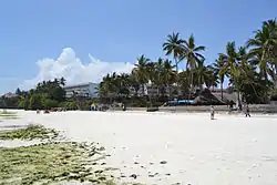
Mombasa County
Mombasa County is one of the 47 counties of Kenya. It's the capital and the only city in the county of Mombasa.[1] Initially it was one of the former districts of Kenya but in 2013 it was reconstituted as a county, on the same boundaries. It is the smallest county in Kenya, covering an area of 229.7 km2 excluding 65 km2 of water mass. The county is situated in the south eastern part of the former Coast Province. It borders Kilifi County to the north, Kwale County to the south west and the Indian Ocean to the east. Administratively, the county is divided into seven divisions, eighteen locations and thirty sub-locations.
Mombasa County | |
|---|---|
 | |
 Flag  Coat of arms | |
| Motto(s): Utangamano kwa Maendeleo (English: Unity for Development) | |
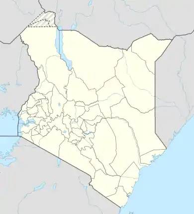 Mombasa County Location of Mombasa County | |
| Coordinates: 4°03′S 39°40′E | |
| Country | |
| Formed | March 4th 2013 |
| Capital | Mombasa |
| Government | |
| • Governor | Hassan Ali Joho |
| Area | |
| • Total | 294.7 km2 (113.8 sq mi) |
| • Land | 219.9 km2 (84.9 sq mi) |
| • Water | 65 km2 (25 sq mi) |
| Elevation | 50 m (160 ft) |
| Population (2019) | |
| • Total | 1,208,333 |
| • Density | 4,100/km2 (11,000/sq mi) |
| Time zone | UTC+3 (EAT) |
| Area code(s) | 020 |
| Website | mombasa.go.ke |
Kenya was divided into eight provinces prior to 2013, which were subdivided into 47 counties. In the former Coast Province there are six counties, Mombasa being one of them. It is situated in the southeast of Coast Province. It is the smallest in size, covering an area of 212.5 km2.[2] The county lies between latitudes 3°56’ and 4°10’ south of the equator and longitudes 39°34’ and 39°46’ east.[3]
Geographical area
The county and the city are divided into four divisions:
- Mombasa Island – 14.1 km²
- Changamwe – 54.5 km²
- Likoni – 51.3 km²
- Kisauni - 109.7 km²
Demographics
Mombasa is an urban city county and for this reason there is a large population of both local and immigrant communities. The local communities include the Mijikenda, Swahili and Kenyan Arabs. The Mijikenda is the largest community in Mombasa county making almost 35% of the total population in the county. The immigrant Kamba community is second largest ethnic community in the county making almost 30% of the total population of the county. The Kamba people have been known for their expansive knowledge of business and trade ranging from small scale to large scale followed closely by their GEMA counterparts. Other significant immigrant communities include the Luo, Luhya and Somali communities.
Constituency
The county is composed of six Parliamentary constituencies:[4]
| Constituency name | Pop. 2009 Census | Area covered | No. of ward | wards |
|---|---|---|---|---|
| Changamwe | 147,613 | 16 | 5 | Port Reitz, Kipevu, Airport, Changamwe, Chaani |
| Jomvu | 102,566 | 29 | 3 | Jomvu Kuu, Miritini, Mikindani |
| Kisauni | 194,065 | 88.7 | 7 | Mjambere, Junda, Bamburi, Mwakirunge, Mtopanga, Magogoni, Shanzu |
| Nyali | 185,990 | 22.88 | 5 | Frere Town, Ziwa la Ngombe, Mkomani, Kongowea, Kadzandani |
| Likoni | 166,008 | 41.10 | 5 | Mtongwe, Shika Adabu, Bofu, Likoni, Timbwani |
| Mvita | 143,128 | 14.80 | 5 | Mji wa Kale/Makadara, Tudor, Tononoka, Majengo Ganjoni/Shimanzi |
| Total | 939,370 | 212.48 | 30 | - |
Mombasa County lies within the coast lowland, which rises gradually from the sea level in the east to slightly over 76 m above sea level in the mainland west. The highest point is at Nguu Tatu hills in the mainland north that rises up to 100 m above sea level.
Services and urbanisation
| County | Stats for the County (Percent) | ||||||||
|---|---|---|---|---|---|---|---|---|---|
| Urbanisation | 100 | ||||||||
| Literacy | 85.8 | ||||||||
| Attending school (15-18 Yrs) | 53.6 | ||||||||
| Paved roads | 28.6 | ||||||||
| Good roads | 32 | ||||||||
| Electricity access | 59 | ||||||||
| Poverty rate | 37.6 | ||||||||
|
Stats for the County | |||||||||
Source: USAid Kenya

References
- "Events – Mombasa County". Retrieved 28 May 2020.
- unep.org – Country-Profile Kenya (.doc)
- "Events – Mombasa County". Retrieved 28 May 2020.
- "Kenya Information". Archived from the original on 14 March 2013. Retrieved 5 July 2013.