Michina
Michina (Quechua for pasture)[2] is a 5,537-metre-high (18,166 ft) mountain in the Cordillera Occidental in the Bolivian Andes. It is located in the Potosí Department, Sur Lípez Province, San Pablo de Lípez Municipality,[3] at the border with Chile. Michina lies within the borders of the Eduardo Avaroa Andean Fauna National Reserve.[4] It is situated south of Tocorpuri.[1]
| Michina | |
|---|---|
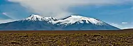 Tocorpuri (on the left) and Michina as seen from Chile in the west | |
| Highest point | |
| Elevation | 5,537 m (18,166 ft) [1] |
| Coordinates | 22°26′20″S 67°53′15″W |
| Geography | |
 Michina Location in Bolivia | |
| Location | Bolivia, Potosí Department, Sur Lípez Province |
| Parent range | Andes, Cordillera Occidental |
References
- Bolivian IGM map 1:250,000 Volcán Juriques SF-19-11
- Teofilo Laime Ajacopa, Diccionario Bilingüe Iskay simipi yuyayk'ancha, La Paz, 2007 (Quechua-Spanish dictionary)
- "San Pablo de Lípez". INE, Bolivia. Archived from the original on January 28, 2016. Retrieved October 8, 2014. (unnamed)
- sernap.gob.bo Reserva National de Fauna Andina Eduardo Avaroa
Capital: Potosí | ||
| Provinces |  | |
| Municipalities (and seats) |
| |
This article is issued from Wikipedia. The text is licensed under Creative Commons - Attribution - Sharealike. Additional terms may apply for the media files.