Minnesota State Highway 16
Minnesota State Highway 16 (MN 16) is a 87.671-mile-long (141.093 km) two-lane highway in southeast Minnesota, which runs from its interchange with Interstate Highway 90 in Dexter and continues east to its eastern terminus at the Wisconsin state line concurrent with U.S. Highways 14 and 61 outside La Crescent just west of La Crosse, Wisconsin.[1]
| ||||
|---|---|---|---|---|
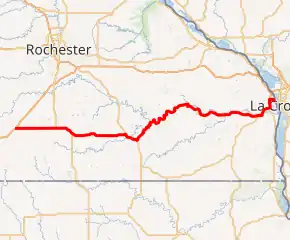
MN 16 highlighted in red | ||||
| Route information | ||||
| Maintained by MnDOT | ||||
| Length | 87.671 mi[1] (141.093 km) | |||
| Existed | 1980[2]–present | |||
| Tourist routes | ||||
| Major junctions | ||||
| West end | ||||
| East end | ||||
| Location | ||||
| Counties | Mower, Fillmore, Houston | |||
| Highway system | ||||
| ||||

The route was designated as a National Scenic Byway in 2003 as the Historic Bluff Country Scenic Byway. The roadway follows the route of old U.S. Highway 16.[3]
Route description
Minnesota Trunk Highway 16 serves as the scenic east–west route in southeast Minnesota. The national scenic byway links together Dexter, Grand Meadow, Spring Valley, Preston, Lanesboro, Rushford Village, Peterson, Rushford, Houston, Hokah, and La Crescent. Highway 16 parallels Interstate 90 throughout its route and allows travelers the opportunity to experience Minnesota's Driftless Area.
The route passes through the Richard J. Dorer Memorial Hardwood State Forest in Fillmore and Houston counties.
Forestville Mystery Cave State Park is located near Highway 16 in Fillmore County. The park is located between Spring Valley and Preston.
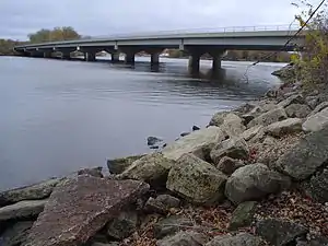
The eastern terminus for Highway 16 is the Wisconsin state line at the Mississippi River outside La Crescent, concurrent with U.S. Highways 14 and 61.
The western terminus for the route is its interchange with Interstate 90 in Dexter.
History
| |
|---|---|
| Location | Manley–La Crescent |
| Existed | 1926–1980 |
| History | Mostly replaced by Interstate 90 |
State Highway 16 was designated in 1980. The route was originally part of old U.S. Highway 16 from 1926 to 1980.
U.S. 16 was mostly replaced by Interstate Highway 90 within Minnesota.
State Highway 16 from Dexter to La Crescent is the only remaining section of this former U.S. route that exists as a trunk highway separate from Interstate 90.
After crossing the Mississippi River Bridge and the Wisconsin state line, old U.S. 16 continues on as Wisconsin Highway 16.[2]
The only section of U.S. Highway 16 that remains in the present day is the east–west route between Rapid City, South Dakota and Yellowstone National Park in Wyoming.
Major intersections
| County | Location | mi[1] | km | Destinations | Notes |
|---|---|---|---|---|---|
| Mower | Dexter | 0.000– 0.202 | 0.000– 0.325 | Western terminus; western end of CSAH 7 overlap; I-90 exit 193; road continues north as CSAH 7 | |
| 0.286 | 0.460 | Eastern end of CSAH 7 overlap | |||
| Frankford Township | 11.182 | 17.996 | Western end of US 63 overlap | ||
| Fillmore | Spring Valley | 16.327 | 26.276 | Eastern end of US 63 overlap | |
| Fillmore Township | 22.602 | 36.374 | |||
| Fountain Township | 31.675 | 50.976 | Western end of US 52 overlap | ||
| Preston Township | 35.210 | 56.665 | Eastern end of US 52 overlap | ||
| Lanesboro | 40.534 | 65.233 | |||
| Rushford | 58.544 | 94.217 | Western end of MN 43 overlap | ||
| Rushford Village | 59.092 | 95.099 | Eastern end of MN 43 overlap | ||
| Houston | Houston | 70.112 | 112.834 | Western end of MN 76 overlap | |
| Houston Township | 70.981 | 114.233 | Eastern end of MN 76 overlap | ||
| Hokah | 82.024 | 132.005 | |||
| La Crescent Township | 85.222 | 137.152 | |||
| La Crescent | 87.671 | 141.093 | Western end of US 14/US 61/I-90 Alt. overlap | ||
| Mississippi River | 89.451 | 143.957 | La Crosse West Channel Bridge | ||
| Continuation into La Crosse, Wisconsin | |||||
1.000 mi = 1.609 km; 1.000 km = 0.621 mi
| |||||
References
- Minnesota Department of Transportation. "Statewide Trunk Logpoint Listing" (PDF). St. Paul: Minnesota Department of Transportation. Retrieved September 2, 2015.
- Riner, Steve. "Details of Routes 1-25". The Unofficial Minnesota Highways Page. Retrieved March 12, 2006.
- Highways and Gas Stations - MN State Highway 16 page Archived March 2, 2012, at the Wayback Machine