Minnesota State Highway 74
Minnesota State Highway 74 (MN 74) is a 34.956-mile-long (56.256 km) highway in southeast Minnesota, which runs from its intersection with U.S. Highway 52 and State Highway 30 in Chatfield and continues north to its northern terminus at its intersection with U.S. Highway 61 at Weaver along the Mississippi River. It is the only remaining road in the state highway system which is still partially unpaved.[1]
| ||||
|---|---|---|---|---|
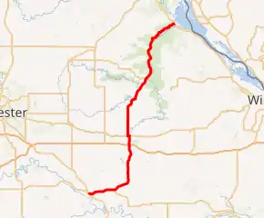
MN 74 highlighted in red | ||||
| Route information | ||||
| Defined by MS § 161.115(5) | ||||
| Maintained by MnDOT | ||||
| Length | 34.956 mi (56.256 km) | |||
| Existed | 1933–present | |||
| Major junctions | ||||
| South end | ||||
| North end | ||||
| Location | ||||
| Counties | Fillmore, Olmsted, Winona, Wabasha | |||
| Highway system | ||||
| ||||

Route description
State Highway 74 serves as a north–south route in southeast Minnesota between Chatfield, St. Charles, Elba, and Weaver. It is legally defined as Legislative Route 74 in the Minnesota Statutes.[2]
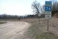
Highway 74 begins at its intersection with U.S. 52 and State Highway 30 in Chatfield and continues north through the unincorporated communities of Troy and Saratoga. Highway 74 has a junction with Interstate 90 just south of St. Charles. In St. Charles, Highway 74 becomes Main Street, also known as Whitewater Avenue, until it joins U.S. Highway 14 briefly. Highway 74 runs concurrent west with Highway 14 for less than a mile. The route continues north again, passing through Whitewater State Park and the town of Elba. The highway ends at its junction with U.S. Highway 61 in Weaver, Minnesota. About 7 miles (11 km) of the northern end of the route through the Whitewater Wildlife Management Area from Beaver to Weaver, in what is known as the Weaver Bottoms, are unpaved gravel.[3][4]
History
Highway 74 was authorized in 1933. The south end of Highway 74 previously extended south of Chatfield to old U.S. Highway 16 at Spring Valley until 1974.[5] As a result of this, the present day mile markers begin at mile 20. Highway 74 follows, in part, an old route which was one of the first public roads in the Minnesota Territory.[6]
In 1953, the route was still gravel south of U.S. Highway 14. Highway 74 was paved by 1960,[5] except for the northernmost 7 miles, which was still gravel as of 2018.[7]
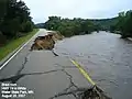
Flood
The 2007 Midwest flooding caused much damage to Highway 74. On August 18 and 19, 2007, the flooded Whitewater River destroyed bridges and washed out the roadway in several places. By 2008, repairs were complete.
Images
Major intersections
| County | Location | mi | km | Destinations | Notes |
|---|---|---|---|---|---|
| Fillmore | Chatfield | 20.040 | 32.251 | Western end of MN 30 overlap | |
| Olmsted | Elmira Township | 24.178 | 38.911 | Eastern end of MN 30 overlap | |
| Winona | St. Charles Township | 32.348 | 52.059 | I-90 exit 233; interchange. | |
| St. Charles | 33.719 | 54.265 | Eastern end of US 14 overlap | ||
| 33.945 | 54.629 | Western end of US 14 overlap | |||
| Wabasha | Weaver | 54.996 | 88.507 | ||
1.000 mi = 1.609 km; 1.000 km = 0.621 mi
| |||||
References
- Minnesota Department of Transportation (2018). "Minnesota's Aging Infrastructure" (PDF): 2.
Today, almost all of the state highway system has been paved, with the exception of 14 lane-miles on Minnesota Highway 74 near Weaver, Minnesota in the southeast part of the state.
Cite journal requires|journal=(help) - "161.115, Additional Trunk Highways". Minnesota Statutes. Office of the Revisor of Statutes, State of Minnesota. 2010. Retrieved October 29, 2010.
- "Answer Man: Highway is road not taken by pavers". Post-Bulletin. Rochester, Minnesota. October 26, 2012.
- "Hwy 74 reopens Beaver to Weaver in Whitewater Wildlife Management Area". Minnesota Department of Transportation. State of Minnesota. May 22, 2017.
The stretch from Beaver (Winona County Road 30) to Weaver (Wabasha County Road 26) is MnDOT’s only gravel road and is within the Whitewater Wildlife Management Area north of Elba.
- Riner, Steve. "Details of routes 51–75". The Unofficial Minnesota Highways Page. Self-published. Retrieved October 29, 2010.
- "The Top Ten Motorcycle Rides of Southeastern Minnesota?". Rochester Magazine. Rochester Post-Bulletin. September 25, 2016.
Some portions date back to earliest public roads in the territory.
- Krueger, Andrew (July 28, 2018). "Rustic remnant: A trip along Minnesota's last unpaved state highway". Minnesota Public Radio. Weaver, Minnesota.
A seven-mile gravel stretch of the highway is the last unpaved road maintained by state transportation workers.