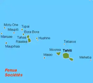
Mo'orea
Mo'orea (English: /ˌmoʊ.oʊˈreɪ.ɑː/ or /ˈmoʊ.oʊreɪ/;[4] Tahitian: /moʔore(ʔ)a/), also spelled Moorea, is a volcanic island in French Polynesia. It is one of the Windward Islands, a group that is part of the Society Islands, 17 kilometres (11 mi) northwest of Tahiti. The name comes from the Tahitian word Mo'ore'a, meaning "yellow lizard": Mo'o = lizard ; Re'a (from re'are'a) = yellow.[5] An older name for the island is 'Aimeho, sometimes spelled 'Aimeo or 'Eimeo (among other spellings that were used by early visitors before Tahitian spelling was standardized). Early Western colonists and voyagers also referred to Mo'orea as York Island.
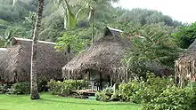
View of Mo'orea | |
 | |
| Geography | |
|---|---|
| Location | Pacific Ocean |
| Coordinates | 17°32′S 149°50′W |
| Archipelago | Society Islands |
| Area | 134 km2 (52 sq mi) |
| Highest elevation | 1,207 m (3960 ft) |
| Highest point | Mont Tohive'a[1] |
| Administration | |
France | |
| Overseas collectivity | French Polynesia |
| Administrative subdivision | Windward Islands |
| Commune | Mo'orea-Mai'ao |
| Capital city | 'Āfareaitu |
| Largest settlement | Pao Pao–Maharepa (4,244 inhabitants) |
| Demographics | |
| Population | 16,191[2] (Aug. 2007 census) |
| Pop. density | 121/km2 (313/sq mi) |
| Official name | Lagon de Moorea |
| Designated | 15 September 2008 |
| Reference no. | 1834[3] |
History
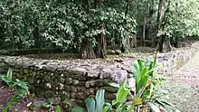
Like many of the other islands, Mo'orea was first settled by Polynesians who came from the islands west of Mo'orea. They came down from South Asia in canoes, looking for islands to settle on. It is estimated that they arrived on Mo'orea roughly 1000 years ago. There are some ancient landmarks on Mo'orea known as marae, which are rocks shaped like pyramids, in which are carvings that tell when sacrifices occasionally took place. The oldest is the 'Āfareaitu Marae, located in the island's main village. It was crafted by the early Polynesians in the year 900.
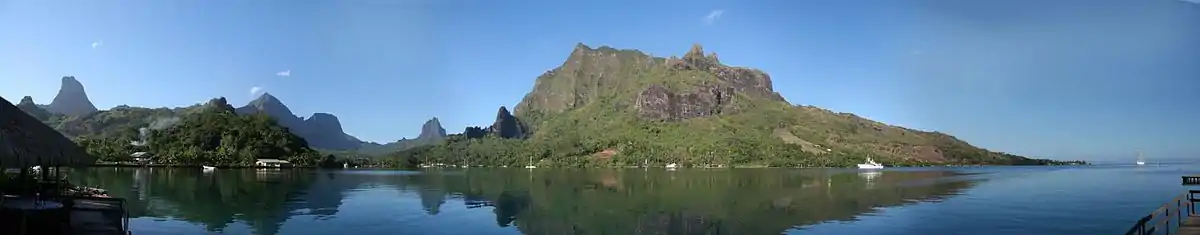
The first European to sight the island was Pedro Fernandes de Queirós, in 1606.[6] The first European settlers arrived during the 18th century. The first Europeans to arrive on the island were the Englishmen Samuel Wallis and James Cook. Captain James Cook first landed on Tahiti, where he planned the 1769 Transit of Venus observed from Tahiti and Mo'orea. At Mo'orea, where Ta'aroa was chief, Cook first landed in 'Ōpūnohu Bay, Cook's Bay was later named in his honor. Spanish sailor Domingo de Bonechea visited it in 1774 and named it Santo Domingo.[7][8]
The island was among those visited by the United States Exploring Expedition on its tour of the South Pacific in 1839.[9]
Charles Darwin found inspiration for his theory regarding the formation of coral atolls when looking down upon Mo'orea while standing on a peak on Tahiti. He described it as a "picture in a frame", referring to the barrier reef encircling the island.[10]
Don the Beachcomber lived here briefly in the late 1920s. His houseboat was destroyed by tropical cyclones after he moved it from Waikiki after 1947.[10]
On October 7, 1967, construction was completed on the Mo'orea Airport, which opened the following month.[11]
Geography
The island was formed as a volcano 1.5 to 2.5 million years ago, the result of the Society hotspot in the mantle under the oceanic plate that formed the whole of the Society Archipelago.[1] It is theorized that the current bays were formerly river basins that filled during the Holocene searise.
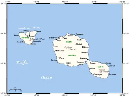
Mo'orea is about 10 miles across. There are two small, nearly symmetrical bays on the north shore. The one to the west is called 'Ōpūnohu Bay. The main surrounding communes of the bay are Piha'ena in the east and Papetō'ai to the west. The one to the east is Cook's Bay, also called Pao Pao Bay since the largest commune of Mo'orea is at the bottom of the bay. The other communes are Piha'ena to the west and busy Maharepa to the east. The highest point is Mount Tohivea, near the center of Mo'orea. It dominates the vista from the two bays and can be seen from Tahiti. There are also hiking trails in the mountains. Vai'are Bay is another small inlet, smaller than the two main bays, on the east shore. The main village is located just south of the bay.
Politics
The island is administratively part of the commune (municipality) of Mo'orea-Mai'ao, itself in the administrative subdivision of the Windward Islands. The main village is 'Āfareaitu.[12] The largest village is Pao Pao at the bottom of Cook's Bay. The second largest is Maharepa.
Transportation
Several ferries go to the Vai'are wharf in Mo'orea daily from Pape'ete, the Tahitian capital. Mo'orea's Tema'e Airport has connections to the international airport in Pape'ete and onward to other Society Islands such as Bora Bora. There is one road that goes around the island.
Tourism
Because of its stunning scenery and accessibility to Pape'ete, Mo'orea is visited by many western tourists who travel to French Polynesia. Especially popular as a honeymoon destination, Mo'orea can often be seen in advertisements in American wedding magazines. Arthur Frommer declared in Frommer's travel guide that he considered it the most beautiful island in the world.[13]
Research facilities
The University of California, Berkeley maintains the Richard B. Gump South Pacific Research Station on the west coast of Cook's Bay.[14] The Gump station is also home to the Mo'orea Coral Reef Long Term Ecological Research Site (MCR LTER), part of a network established by the National Science Foundation in 1980 to support research on long-term ecological phenomena. The Mo'orea Coral Reef LTER became the 26th site in the network in September 2004.
The French École pratique des hautes études (EPHE) and the Centre national de la recherche scientifique (National Centre for Scientific Research; CNRS) maintain a research station at the end of 'Ōpūnohu Bay. This Centre de Recherches Insulaires et Observatoire de l'Environnement (Centre for island research and environment observatory) is a research site for several international projects, including the monitoring of coral reefs throughout French Polynesia as well as the monitoring of the fish population on the Tīahurā transect of Mo'orea's reef.
Popular culture
In the film Love Affair, a scene where Warren Beatty's character visits his aunt takes place on Mo'orea.
Jimmy Buffett has stated that Mo'orea is the inspiration for his song "One Particular Harbor".
References
- Scheffel, Richard L.; Wernet, Susan J., eds. (1980). Natural Wonders of the World. United States of America: Reader's Digest Association, Inc. p. 257. ISBN 0-89577-087-3.
- Institut Statistique de Polynésie Française (ISPF). "TABLEAU II Population des communes et communes associées de Polynésie française" (PDF) (in French). Archived from the original (PDF) on 2008-02-29. Retrieved 2007-12-02.
- "Lagon de Moorea". Ramsar Sites Information Service. Retrieved 25 April 2018.
- "Mooréa". Merriam-Webster Dictionary. March 13, 2017.
- Sven Wahlroos (2002). English–Tahitian, Tahitian–English Dictionary (First ed.). Honolulu: The Mā'ohi Heritage Press. p. 312, 545. ISBN 0-9627095-7-3.
- Rienzi, M.L. Historia de la Oceanía, o quinta parte del mundo Barcelona, 1845-1846, vII, p.267
- Boenechea, Domingo de Descripción de las islas del Océano Pacífico reconocidas últimamente de ordne de S.M., por Don Domingo de Boenechea, capitan de fragata de la Real Armada, y comandante de la de S.M. nombrada Sta. María Magdalana (alias el Aguila), en los años de 1772 y 1774 Manuscript 476 of the Museo Naval de Madrid, fo. 94
- Salmond, Anne (2010). Aphrodite's Island. Berkeley: University of California Press. pp. 38, 173. ISBN 9780520261143.
- Stanton, William (1975). The Great United States Exploring Expedition. Berkeley: University of California Press. pp. 130. ISBN 0520025571.
- "Moorea "The Majestic Island"". Fly Tahiti. Retrieved 25 July 2014.
- La SETIL Aéroports exploitant des aéroports: Tahiit Faa'a, Bora Bora, Raiatea, Rangiroa, Huahine, Moorea
- Archived March 2, 2007, at the Wayback Machine
- "Frommer's The Most Beautiful Islands". 2010-03-02. Retrieved 2010-03-02.
- Richard B. Gump South Pacific Research Station
External links
![]() Moorea travel guide from Wikivoyage
Moorea travel guide from Wikivoyage
![]() Media related to Moorea at Wikimedia Commons
Media related to Moorea at Wikimedia Commons
- Official site (Tahiti Tourisme Board)
- Mo'orea Visitors Bureau
- Mo'orea Travel Information
- Directory: direct links about Mo'orea
- Photogallery of Mo'orea
- Mo'orea Coral Reef Long Term Ecological Research Site
- U.C. Berkelely Richard B. Gump South Pacific Research Station
- "Surgical Strike: Mo'orea Surf Mission" Photos And Video
- The Island of Mo'orea at the Smithsonian Ocean Portal
| Authority control |
|---|
