Mount Chief Pascall
Mount Chief Pascall is a 2,206-metre (7,238-foot) mountain summit located in the Joffre Group of the Lillooet Ranges, in southwestern British Columbia, Canada. It is situated 26 km (16 mi) east of Pemberton, 8 km (5 mi) southwest of Duffy Lake, and within Nlháxten/Cerise Creek Conservancy. Cayoosh Pass lies immediately northwest of the mountain, with Cayoosh Mountain on the opposite side of the pass. Its nearest higher peak is Joffre Peak, 2.1 km (1 mi) to the south, and Mount Rohr rises 5 km (3 mi) to the northeast. The mountain's name was submitted by Karl Ricker of the Alpine Club of Canada to honor Chief Bill Pascall, an early leader of the Lillooet Band.[3] The name was officially adopted on January 23, 1979, by the Geographical Names Board of Canada.[2] Precipitation runoff from the peak drains into tributaries of Cayoosh Creek.
| Mount Chief Pascall | |
|---|---|
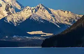 Mount Chief Pascall seen from Duffy Lake | |
| Highest point | |
| Elevation | 2,206 m (7,238 ft) [1] |
| Prominence | 296 m (971 ft) [1] |
| Parent peak | Joffre Peak (2721 m)[1] |
| Coordinates | 50°21′35″N 122°26′52″W [2] |
| Geography | |
 Mount Chief Pascall Location in British Columbia  Mount Chief Pascall Mount Chief Pascall (Canada) | |
| Location | British Columbia, Canada |
| Parent range | Joffre Group Lillooet Ranges Coast Ranges |
| Topo map | NTS 92J/8 |
| Climbing | |
| Easiest route | Scrambling, via Cerise Creek drainage[1] |
Climate
Based on the Köppen climate classification, Mount Chief Pascall is located in a subarctic climate zone of western North America.[4] Most weather fronts originate in the Pacific Ocean, and travel east toward the Coast Mountains where they are forced upward by the range (Orographic lift), causing them to drop their moisture in the form of rain or snowfall. As a result, the Coast Mountains experience high precipitation, especially during the winter months in the form of snowfall. Temperatures can drop below −20 °C with wind chill factors below −30 °C. The months July through September offer the most favorable weather for climbing Mount Chief Pascall.
References
- "Mount Chief Pascall". Bivouac.com. Retrieved 2019-11-14.
- "Mount Chief Pascall". Geographical Names Data Base. Natural Resources Canada. Retrieved 2019-11-14.
- "Mount Chief Pascall". BC Geographical Names.
- Peel, M. C.; Finlayson, B. L.; McMahon, T. A. (2007). "Updated world map of the Köppen−Geiger climate classification". Hydrol. Earth Syst. Sci. 11. ISSN 1027-5606.
External links
- Weather forecast: Mount Chief Pascall
- Climbing Mount Chief Pascall in winter: YouTube

Mount Chief Pascall is located in lower left corner (see file annotations)