Mount Cromwell
Mount Cromwell is a mountain located in the Sunwapta River Valley of Jasper National Park, in Alberta, Canada. Cromwell lines two km north of the east summit of Stutfield Peak. The mountain was named in 1972 by J. Monroe Thorington after Oliver Eaton (Tony) Cromwell, an American climber who made many first ascents in the Canadian Rockies.[1]
| Mount Cromwell | |
|---|---|
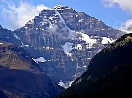 Mt. Cromwell's north face from the Icefields Parkway in 2009 | |
| Highest point | |
| Elevation | 3,330 m (10,930 ft) [1] |
| Prominence | 330 m (1,080 ft) [2] |
| Listing | List of mountains of Alberta |
| Coordinates | 52°16′10″N 117°23′30″W [1] |
| Geography | |
 Mount Cromwell Location in Alberta | |
| Location | Alberta, Canada |
| Parent range | Winston Churchill Range |
| Topo map | NTS 83C/06 |
| Climbing | |
| First ascent | 1938 |
| Easiest route | rock/snow climb |
The first ascent was made in 1938 by E. Cromwell, E. Cromwell jr., F.S. North, J. Monroe Thorington, guided by Edward Feuz jr.[1]
In 2005, Bill Corbett, author of "The 11,000ers of the Canadian Rockies," climbed to the top of Mount Cromwell. At the summit, his GPS registered 11,006 feet. So perhaps Mount Cromwell should be included in the list of the Canadian Rocky Mountains that are over 11,000 feet in elevation.[1]
Climate
Based on the Köppen climate classification, Cromwell is located in a subarctic climate with cold, snowy winters, and mild summers.[3] Temperatures can drop below -20 C with wind chill factors below -30 C. Precipitation runoff from the mountain drains into the Athabasca River.
See also
References
- "Mount Cromwell". PeakFinder.com. Retrieved 2004-06-05.
- "Mount Cromwell". Bivouac.com. Retrieved 2008-12-31.
- Peel, M. C.; Finlayson, B. L.; McMahon, T. A. (2007). "Updated world map of the Köppen−Geiger climate classification". Hydrol. Earth Syst. Sci. 11: 1633–1644. ISSN 1027-5606.
External links
- Parks Canada web site: Jasper National Park