Mount King George (British Columbia)
Mount King George is a prominent 3,413-metre (11,198-foot) mountain summit located in Height of the Rockies Provincial Park, in the Canadian Rockies of British Columbia, Canada. The mountain is the highest point of The Royal Group, a subset of the Rockies, which includes Mount Queen Mary, Mount Princess Mary, Mount Prince George, Mount Prince Albert, Mount Prince Henry, Mount Prince John, and Mount Prince Edward.[2] Its nearest higher peak is Mount Joffre, 16.0 km (9.9 mi) to the east.[1] Mount King George is composed of sedimentary rock laid down during the Cambrian period. Formed in shallow seas, this sedimentary rock was pushed east and over the top of younger rock during the Laramide orogeny.[3]
| Mount King George | |
|---|---|
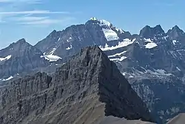 Mount King George, highest peak in the distance | |
| Highest point | |
| Elevation | 3,413 m (11,198 ft) [1] |
| Prominence | 1,329 m (4,360 ft) [1] |
| Parent peak | Mount Joffre (3433 m)[1] |
| Listing | Canada highest major peaks 44th |
| Coordinates | 50°35′47″N 115°24′18″W [1] |
| Geography | |
 Mount King George Location of Mount King George in British Columbia  Mount King George Mount King George (Canada) | |
| Location | Height of the Rockies Prov. Park British Columbia, Canada |
| Parent range | The Royal Group Canadian Rockies |
| Topo map | NTS 82J11 |
| Geology | |
| Age of rock | Cambrian |
| Type of rock | sedimentary rock |
| Climbing | |
| First ascent | 1919 by Val Fynn, Rudolph Aemmer[1] |
| Easiest route | Mountaineering |
History
The mountain was named in 1917 by the Interprovincial Boundary Survey after King George V (1865–1936).[4] [5] The name was officially adopted 23 February 1918.
The first ascent of Mount King George was made 10 August 1919 by Val Fynn with Rudolph Aemmer as guide.[6] Owing in part to the remoteness of the peak and the difficulty of the first ascent, the second ascent of the mountain wasn't made until 1970 by Gerry Brown, William Hurst, and John Carter.[7]
Climbing
Established climbing routes on Mount King George:[8]
- East Face-North Ridge class 5.3 (1919 route of the first ascent)
- Southeast Ridge class 5.3 (1970 route of the second ascent)
- Southwest Face-West Ridge (1971 route of the third ascent by D. Hurrell, R. Mills)
- Congdon-McNab Coulior (FA 1980 by Dwayne Congdon, Dave McNab)
- East Face (FA 1984 by F. Campbell, R. Varnam, K. Nagy)
- Elzinga-Welsted class 5.6 (FA 2012 by Jim Elzinga, Ian Welsted)
Climate
Based on the Köppen climate classification, Mount King George is located in a subarctic climate zone with cold, snowy winters, and mild summers.[9] This climate supports the King George Glacier on the eastern slope of the mountain. Temperatures can drop below −20 °C with wind chill factors below −30 °C. Precipitation runoff from the mountain drains into tributaries of the Palliser River. In terms of favorable weather, the best months for climbing are July through September, with late summer being best for crossing the Palliser River.
References
- "Mount King George". Bivouac.com. Retrieved 2019-07-19.
- "The Royal Group". Geographical Names Data Base. Natural Resources Canada. Retrieved 2019-07-19.
- Gadd, Ben (2008). "Geology of the Rocky Mountains and Columbias". Cite journal requires
|journal=(help) - Mount King George, BC Geographical Names
- W., Boles, Glen (2006). Canadian mountain place names : the Rockies and Columbia Mountains. Laurilla, Roger W., 1959-, Putnam, William Lowell., Putnam, William Lowell. Place names of the Canadian Alps. Calgary, Alta.: Rocky Mountain Books. ISBN 9781894765794. OCLC 244770225.
- Mount King George PeakFinder
- The 11,000ers of the Canadian Rockies, Bill Corbett, Rocky Mountain Books, 2004.
- Summitpost.org Mount King George
- Peel, M. C.; Finlayson, B. L. & McMahon, T. A. (2007). "Updated world map of the Köppen−Geiger climate classification". Hydrol. Earth Syst. Sci. 11: 1633–1644. ISSN 1027-5606.
External links
- Mount King George photo: Flickr
- Mount King George: weather forecast
- BC Parks: Height of the Rockies Provincial Park