Mount Melbourne
Mount Melbourne is a 2,733-metre-high (8,967 ft) ice-covered stratovolcano in Victoria Land, Antarctica, between the Wood Bay and Terra Nova Bay. It is an elongated mountain with a summit caldera filled with ice with numerous parasitic vents; a volcanic field surrounds the edifice. Mount Melbourne has a volume of about 180 cubic kilometres (43 cu mi) and consists of tephra deposits and lava flows; tephra deposits are also found encased within ice and have been used to date the last eruption of Mount Melbourne to 1892 ± 30 CE. The volcano is considered inactive.
| Mount Melbourne | |
|---|---|
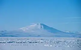 Mount Melbourne seen from the ice-covered Ross Sea | |
| Highest point | |
| Elevation | 2,730 m (8,960 ft) [1] |
| Prominence | 1,699 m (5,574 ft) [1] |
| Listing | Ultra |
| Coordinates | 74°21′S 164°42′E [2] |
| Geography | |
 Mount Melbourne | |
| Geology | |
| Age of rock | Unknown |
| Mountain type | Stratovolcano |
| Volcanic belt | McMurdo Volcanic Group |
| Last eruption | 1892 ± 30 years |
The volcano is part of the McMurdo Volcanic Group, and together with The Pleiades, Mount Overlord, Mount Rittmann and the Malta Plateau forms a subprovince, the Melbourne volcanic province. The volcanism is related both to the West Antarctic Rift and to local tectonic structures such as faults and grabens. Mount Melbourne has mainly erupted trachyandesite and trachyte, which formed within a magma chamber; basaltic rocks are less common.
Geothermal heat flow on Mount Melbourne has created a unique ecosystem formed by mosses and liverworts that grow between fumaroles, ice towers, and ice hummocks. This type of vegetation is found at other volcanoes of Antarctica and develops when volcanic heat generates meltwater from snow and ice, thus allowing plants to grow in the cold Antarctic environment. These mosses are particularly common in an area known as Cryptogam Ridge within and south of the summit caldera; Cryptogam Ridge is a protected area.
Description
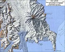
Mount Melbourne lies in North Victoria Land,[3] facing the Wood Bay of the Ross Sea. To the southeast lies Cape Washington and due south lies Terra Nova Bay; Campbell Glacier runs west from the volcano[4] and Tinker Glacier lies north of the volcanic field.[5] The seasonal[6] Italian Zucchelli Station lies 40 kilometres (25 mi) from the volcano;[7] the Korean Jang Bogo Station[8] and the German Gondwana Station are also in the area.[9] The volcano[10] and its summit can be accessed from the stations by helicopter.[11] Mount Melbourne was first recognized as a volcano by James Ross in 1841[12] and named after then-prime minister of the United Kingdom Melbourne.[13] The volcano and its surroundings were investigated by New Zealand-based parties in the 1960s, by German ones in the 1970–1980s and by Italian-based parties in the 1980s–1990s.[14]
The volcano
Mount Melbourne is an elongated stratovolcano[15][lower-alpha 1] formed by lava flows and tephra fall deposits, with gentle slopes.[17] The volcano is uneroded and forms an almost-perfect cone.[18] Viewed from distance Mount Melbourne has a nearly perfect cone-like profile that has drawn comparisons to Mount Etna in Italy and Mount Ruapehu in New Zealand.[19] Volcanic mounds, cones,[19] lava domes and scoria cones dot its flanks;[2] 6.4 kilometres (4 mi) from the summit[20] is a large parasitic vent on the north-northeastern slope,[4] which generated several lava flows.[21] Part of the edifice rises from below sea level.[22] Pyroclastic flow deposits have also been reported, a rarity for Antarctic volcanoes.[16] The total volume of the edifice is about 180 cubic kilometres (43 cu mi).[23]
A 1-kilometre-wide (0.62 mi)[24] caldera sits at the top of the volcano. The highest point of the volcano lies east-northeast of the caldera and reaches 2,733 metres (8,967 ft)[lower-alpha 2] elevation.[26] The caldera has an incomplete rim and is filled with snow, leaving a 500-metre-wide (1,600 ft) depression.[27] The rim of the caldera is covered by volcanic ejecta including lapilli and lava bombs, probably the products of the most recent eruption of Mount Melbourne,[28] which overlie a 15-metre-thick (49 ft) layer of pumice lapilli.[29] Three small, nested craters[30] formed by phreatomagmatic eruptions occur on the southern rim of the summit caldera.[2] Pyroclastic fall deposits crop out in the northern rim of the caldera[15] and there are more alternating lava-tephra sequences elsewhere in the summit region. There is evidence of past structural instability (collapse structures) on the eastern and southeastern flank,[31] and an arcuate 50-to-100-metre-high (160 to 330 ft) scarp on the eastern flank appears to be an incipient sector collapse.[29]
Except for geothermal areas, the ground is bouldery.[26] Some of the coasts are rocky.[32] Frost heave has been observed in the summit region.[33] Small creeks flow down the eastern flank of Mount Melbourne;[6] they are fed by meltwater during summer and quickly disappear with the snow.[34]
Glaciation
The mountain is covered with permanent ice, which extends to the coast[3] and leaves only a few exposures of the underlying rock;[27][35] rocky outcrops are best exposed on the eastern flank.[17] The caldera hosts a névé that generates a westward flowing glacier.[33] An icefall lies northwest of the caldera.[26] Glaciers emanating from snowfields on the volcano have deposited moraines;[36] moraines and tills from both Pleistocene and Holocene glaciations crop out at Edmonson Point.[37]
Tephra layers crop out in ice cliffs[38] and seracs[29] and testify to recent eruptions,[39] including the one that deposited the ejecta and lapilli pumice units on the summit.[29] Tephra bands are also found in other glaciers of the region.[39] They form when snow accumulates on top of tephra that fell onto ice[20] and in the case of Mount Melbourne they indicate eruptions during the last few thousand years.[40] Volcanic sediments from Mount Melbourne are also found in Terra Nova Bay.[41]
The volcanic field
Mount Melbourne is surrounded by a volcanic field[42] consisting of 60 exposed volcanoes,[43] which have the form of scoria cones and tuff rings with hyaloclastite deposits, lava flows and pillow lavas. Some of these volcanoes formed under ice.[44] The volcanic field forms a peninsula which is separated by steep faults from the Transantarctic Mountains to the north.[23] Among these volcanoes is Shield Nunatak southwest from Mount Melbourne,[45] a subglacial volcano, now exposed, that may have formed during the latest Pleistocene.[46] The Cape Washington ridge consists mostly of lava, including pillow lava, overlaid by scoria cones,[15] and is the remnant of a shield volcano.[47] Edmonson Point is another volcanic complex in the system that formed partly while interacting with glaciers and partly through phreatomagmatic activity.[48] Other volcanoes in the field are Baker Rocks, Oscar Point and Random Hills.[49] These volcanoes are aligned mainly in north–south direction and include both edifices that formed above and under ice,[2] with palagonitized outcrops that expose dikes.[50] Perfectly preserved scoria cones occur at Pinckard Table north of the volcanic field, while Harrow Peak is a heavily eroded lava plug.[51] The total volume of volcanic rocks is about 250 cubic kilometres (60 cu mi)[23] and their emplacement apparently altered the path of the Campbell Glacier.[52]
Geology
.svg.png.webp)
Mount Melbourne is part of the McMurdo Volcanic Group and together with Mount Erebus one of its active volcanoes.[43] This volcanic group is one of the largest alkaline volcanic provinces in the world,[22] comparable with that of the East African Rift,[14] and is subdivided into the Melbourne, the Hallett and the Erebus volcanic provinces.[53] The volcanic group consists of large shield volcanoes mainly near the coasts, stratovolcanoes and monogenetic volcanoes[14] which formed parallel to the Transantarctic Mountains.[54]
Volcanic activity of the McMurdo Volcanic Group is tied to continental rifting[43] and commenced during the Oligocene.[53] Whether the volcanism is caused by a mantle plume or by the tectonics of the West Antarctic Rift is unclear.[55] The latter is one of the largest continental rifts on Earth but little known and possibly inactive today. The Ross Sea and the Victoria Land Basin developed along this rift[56] and were deeply buried, while the Transantarctic Mountains were rapidly uplifted during the last 50 million years[57] and are on the "shoulder" of the rift.[58] The line separating the two is a major crustal suture, with large differences in elevation and crustal thickness across the suture.[59] Many of the volcanoes appear to have formed under the influence of fault zones in the area,[60] and increased activity in the last 30 million years has been correlated to the reactivation of faults.[14]
It is part of a volcano alignment that includes The Pleiades, Mount Overlord,[61] Mount Rittmann—all large stratovolcanoes—[62] which with the Malta Plateau form the Melbourne province of the McMurdo Volcanic Group.[22][63] In addition, this province consists of numerous smaller volcanic centres, volcanic intrusions and sequences of volcanic rocks,[64] and has been active for the past 25 million years.[30] Volcanic edifices buried under sediment are also part of the Melbourne province, including a cone southeast from Cape Washington, which has a size comparable to that of Mount Melbourne.[65]
Mount Melbourne and its volcanic field are over a basement of Precambrian to Ordovician age, which consists of volcanic and metamorphic rocks of the Wilson Terrane.[47] The volcano is at the intersection of three geological structures: the Rennick Graben of Cretaceous age, the Victoria Land Basin and the Polar 3 magnetic anomaly, which has been interpreted to be either a transform fault or a push-up structure formed by faulting.[56] The Terror Rift in the Victoria Land Basin[66] runs between Mount Melbourne and Mount Erebus[59] and appears to be related to their existence.[10] The volcano appears to rise in a graben whose marginal faults are still active with earthquakes, on the eastern flank of Mount Melbourne.[67] North–south-trending faulting may also be responsible for the north–south-like trend in edifice structure,[52] and strike-slip faulting takes place on the eastern flank.[44] Recent offset on faults[68] and Holocene coastal uplift in the area indicates that tectonic activity is still ongoing.[45]
Low seismic velocity anomalies have been found underneath Mount Melbourne and are connected to similar anomalies under the Terror Rift.[69] These anomalies above 100 kilometres (62 mi) depth are focused under Mount Melbourne and the neighbouring Priestley Fault.[70] A low gravity anomaly over Mount Melbourne may reflect either the presence of low-density volcanic rocks or of a magma chamber under the volcano.[71]
Composition
Trachyandesite and trachyte are the most common rocks on Mount Melbourne, with basalt being less common[42] and mostly occurring around its base. The rocks define a mildly alkaline suite[17] rich in potassium unlike the rocks elsewhere in the volcanic field. The rest of the volcanic field also features alkali basalts, basanite and mugearite. Phenocrysts include aegirine, amphibole, anorthoclase, augite, clinopyroxene, hedenbergite, ilmenite, magnetite, olivine, plagioclase and sanidine.[72][73] Gneiss,[47] granulite, harzburgite, lherzolite and tholeiite xenoliths are found in the volcanic field[44] and form the core of many lava bombs.[28] Inclusions in xenoliths indicate that the gaseous components of the Mount Melbourne volcanic field magmas consist mainly of carbon dioxide.[74]
The trachytes and mugearites formed through magmatic differentiation in a crustal magma chamber[7] from alkali basalts,[75] defining an alkali basalt-trachyte differentiation series.[76] Basalts were mainly erupted early in the history of the volcano.[7] During the last 100,000 years, the magma chamber became established; this allowed both the differentiation of trachytes and the occurrence of large eruptions.[77] A gap in the rock spectrum ("Daly gap") with a scarcity of benmoreite and mugearite has been noted at Mount Melbourne and other volcanoes in the region.[35] There is no agreement on which processes contributed to petrogenesis in the Mount Melbourne volcanic field.[78] The magmatic system that feeds Mount Melbourne appears to have a distinct composition from the one associated with the Mount Melbourne volcanic field.[79]
Hydrothermal alteration has affected parts of the summit area, leaving yellow and white deposits that contrast with the black volcanic rocks.[80][81] Hydrothermal sinter deposits have formed in geothermal areas[33] from past liquid water flow.[82] Clay containing allophane, amorphous silica, allophane and feldspar are found in the summit area.[83]
Eruption history
Mount Melbourne was active during the last 3[30]–2.7 million years.[75] Activity has been subdivided into an older Pliocene Cape Washington stage, an early Pleistocene Random Hills stage, the 400,000–100,000 years old Shield Nunatak stage[84] and the recent Mount Melbourne stage.[85] Volcanic activity migrated north from Cape Washington towards the Transantarctic Mountains and eventually became centralized at Mount Melbourne.[77] Mount Melbourne during the last 100,000 years has produced about 0.0015 cubic kilometres per year (0.00036 cu mi/a) of magma.[77]
Mount Melbourne volcanic field
Ages obtained on the Mount Melbourne volcanic field include 2.96±0.2 million years,[7] 740,000±100,000 years and 200,000±40,000 years for Baker Rocks, 2.7±0.2 million years and 450,000±50,000 years for Cape Washington, 74,000±110,000 years and 50,000±20,000 years for Edmonson Point, less than 400,000 years for Markham Island, 745,000±66,000 years for Harrows Peak, 1.368±0.09 million years for Pinkard Table, 1.55±0.05 million years, 431,000±82,000 and 110,000±70,000 years for Shield Nunatak, and 2.5±0.1 million years for Willows Nunatak.[86][64] The northeastern parasitic cone formed after the bulk of the volcano and appears to be younger than the summit of Mount Melbourne.[20]
Radiometric dating has shown that the appearance of a landform at Mount Melbourne is not indicative of its age; some well preserved vents are older than heavily eroded ones.[84] On the other hand, a lack of proper margins of error and lack of details on which samples were dated has been problematic for radiometric dating efforts.[47]
Tephra
Tephra found at the Allan Hills,[87] in Dome C[12] and Siple Dome ice cores may come from Mount Melbourne.[88] Some marine tephra layers originally attributed to Mount Melbourne may instead come from Mount Rittmann.[89] Additional tephra layers attributed to the volcano are:
- Less than 500,000 years old tephra layers in the Frontier Mountain and Lichen Hills blue-ice areas have been attributed to volcanoes in the Mount Melbourne volcanic province.[90]
- A less than 30,000 years old tephra layer in a sediment core from the Ross Sea has a composition indicating that it was erupted at Mount Melbourne. Its deposition has been used to infer that that part of the western Ross Sea was ice-free at that time.[91]
- A tephra layer found in the Ross Sea has been interpreted as originating from an eruption of Mount Melbourne 9,700±5,300 years ago.[92]
- In the Talos Dome ice core record, two tephra layers emplaced 2,680 and 5,280 years ago have compositions similar to these of Mount Melbourne.[93]
- Tephra layers at Siple Dome indicate eruptions at Mount Melbourne 304 CE,[94] which deposited substantial amounts of sulfate on the ice sheet.[95]
- A tephra layer at Siple Dome dated to 1810 CE might have been erupted by Mount Melbourne, but its attribution is less certain than for the 304 CE tephra.[96]
Mount Melbourne proper
The Edmonson Point ignimbrite is a trachytic ignimbrite that crops out at Edmonson Point. It consists of three units of ash-supported, lapilli- and pumice-rich deposits with intercalated breccia lenses that reach a thickness of 30 metres (98 ft). They are two ignimbrite units separated by a base surge deposit. Faulting has offset the sequences, which are intruded by dikes.[47] The Edmonson Point ignimbrite was produced by large Plinian eruptions[97] and is about 120,000 years old.[86] The eruption deposited tephra into the Ross Sea,[98] and correlative tephra layers were found in the Talos Dome ice core.[99]
After this ignimbrite, a series of dikes gave rise to the probably subglacial Adelie Penguin Rookery lava field. This lava field is formed by numerous blocky lava flows with glassy margins that reach a total thickness of 300 metres (980 ft) and are formed by hawaiite[97] and benmoreite.[100] They were fed through numerous dikes, which also gave rise to small scoria cones and spatter cones, and were emplaced non-contemporaneously.[97] A tuff cone rises from the lava field and is formed by monogenetic volcano ejecta, including lava bombs encasing granite fragments and bombs large enough to leave craters in the ash they fell in.[100] Ropy basalt lava flows with an uncertain source vent, and a undissected scoria cone rise above the lava field and complete the Edmonson Point system.[28] The Adelie Penguin Rookery lava field was erupted about 90,000 years ago,[86] and its emplacement may have been accompanied by the emission of tephra recorded in the Talos Dome ice core.[101]
Rocks at the summit have ages of between 260,000 and 10,000 years.[102][64] Individual eruptions have been dated to 10,000±20,000, 80,000±15,000, 260,000±60,000 and 15,000±35,000 years ago.[103] Highly inprecise ages of late Pleistocene to Holocene age have been obtained from the ejecta layer on the summit.[86]
Last eruption and present-day activity
The last eruption was a few centuries ago,[42] and tephrochronology has yielded an age of 1892±30 CE for it.[2] This eruption deposited a major tephra layer around the volcano, which crops out mainly on its eastern side[30] and in the Aviator and Tinker Glaciers.[104] The three small craters on the rim of the Mount Melbourne summit crater formed at the end of this eruption.[105]
No eruptions have been observed during historical time,[43] and the volcano is considered to be quiescent[lower-alpha 3] and a low-hazard volcano.[107][54] Ongoing deformation and seismic activity occurs at Mount Melbourne,[108][109] and the latter may be caused either by the movement of fluids underground or by fracturing processes.[110] Geothermal activity has been steady between 1963 and 1983,[17] while ground deformation commenced in 1997. This deformation was probably caused by changes in the geothermal system.[111]
Hazards and monitoring
Future moderate explosive eruptions are possible.[22] The prevailing winds would transport volcanic ash eastward across the Ross Sea,[105] and the ash might impact research stations close to Mount Melbourne such as Mario Zucchelli, Gondwana and Jang Bogo.[112] The hazards of Antarctic volcano eruptions are poorly known.[113] Mount Melbourne is remote, and thus renewed eruptions[111] would likely not impact any human habitations, but regional environmental or even global climate impacts are possible.[114]
Italian scientists began a volcanology research program on Mount Melbourne in the late 1980s,[109] establishing a volcanological observatory in 1988.[44] In 1990 they installed seismic stations around Mount Melbourne[109] and between 1999 and 2001 a network of geodetic measurement stations around Terra Nova Bay, including several aimed at monitoring the Mount Melbourne volcano.[115] Beginning in 2012, Korean scientists at the Jang Bogo Station added another seismic station network to monitor the volcano.[69]
Geothermal activity
Geothermal activity occurs around the summit crater, on the upper parts of the volcano[42] and on the northwestern slope between 2,400 to 2,500 metres (7,900 to 8,200 ft) elevation.[116] Another geothermal area exists close to Edmonson Point,[117] including fumaroles,[118] thermal anomalies[119] and freshwater ponds. Their temperatures of 15 to 20 °C (59 to 68 °F) are considerably higher than normal atmospheric temperatures in Antarctica.[117] The geothermal areas are visible in infrared light from aircraft.[120] Satellite images have identified areas with temperatures of over 100 to 200 °C (212 to 392 °F).[121]
Individual geothermally heated areas cover surfaces of a few hectares.[17] Typically, the soil consists of a thin sand layer with organic matter covering scoria gravel.[11] In some places, the ground is too hot to be touched.[80] Mount Melbourne is one of several volcanoes in Antarctica that feature such geothermal soils.[122]
Fumarolic landforms include ice towers,[lower-alpha 4] fumaroles,[42] ice "roofs",[124] caves in snow and firn,[17] bare ground,[26] ice hummocks surrounding fumarolic vents,[125] puddles formed by condensed water vapour[11] and steaming ground:[12]
- Ice hummocks are hollow glacial structures that encase fumaroles. They reach heights of 4 metres (13 ft) and widths of 1 to 6 metres (3 to 20 ft).[18] They mainly form over colder ground and widely spaced fumarolic vents.[126]
- Ice towers are widespread around the caldera, especially in the north-northwestern and south-southeastern sectors, while warm ground is more restricted. In the northern sector of the volcano, ice towers and bare ground form a southeast–northwest trending lineament.[26] Ice towers form when fumarolic gases freeze in the cold Antarctic air.[80]
- Glacial caves form when geothermal heat melted ice, leaving cavities. Some of these caves are in the summit caldera and reach lengths of several hundred metres, with ceilings reaching 3 metres (9.8 ft) height.[17] Several caves have been accessed through ice towers[127] or through gaps where the ice surrounding the cave rests on rock.[128]
The caves and ice towers release water vapour-rich warm air.[127] Fumarole temperatures can reach 60 °C (140 °F), contrasting with the cold air.[22] Hydrogen sulfide gas has been detected in fumaroles[80] but is not common, facilitating the development of vegetation.[102] Yellow deposits have been identified as sulfur.[129]
The geothermal manifestations appear to be powered mainly by steam, as there is no evidence of geothermal landforms related to liquid water flow and heat conduction is not effective enough at most sites. It is possible that underground liquid water reservoirs form in some areas, however. The steam is produced by the melting and evaporation of snow and ice, and is then channelled through rocks to the vents. Atmospheric air likely circulates underground and is heated, eventually exiting in ice towers.[124]
Climate
There are no detailed meteorological records of the summit region.[11] Winds blow mostly from the west[130] and more rarely from the northwest. Catabatic winds blow from the Priestly and Reeves valleys.[77] Precipitation is scarce. During winter, polar night lasts about three months.[131]
Temperatures not exceeding −30 °C (−22 °F)[117] or of −6 to −20 °C (21 to −4 °F) have been recorded in the summit region.[132] Seasonal temperature variation is high and reaches 30 °C (54 °F).[133] As part of climate change, temperatures on the Antarctic Peninsula have increased while the interior continent has cooled;[133] at Mount Melbourne temperature declined between 1989 and 1998.[134]
During the Last Glacial Maximum (LGM), a marine ice sheet occupied Terra Nova Bay. The "Terra Nova Drift" was deposited between 25,000 and 7,000 years ago and is overlaid by later moraines from retreating ice during the post-LGM period.[135] During the late Holocene after 5,000 years before present, glaciers advanced again as part of the Neoglacial.[136] One minor advance occurred in the last c. 650 years.[36]
Life
Algae,[lower-alpha 5][125] lichens,[140] liverworts[lower-alpha 6] and mosses[lower-alpha 7][3] grow on geothermally heated terrain on the upper parts of Mount Melbourne. Algae form crusts on the heated ground. Mosses form cushions[125] and often occur around steam vents[26] and under ice hummocks.[143] The moss species Campylopus pyriformis does not grow leaves on Mount Melbourne.[3] Pohlia nutans forms small shoots.[144] The two moss species form separate stands[145] that occur at different sites of the volcano.[146] Together with occurrences at Mount Erebus, they constitute the highest mosses growing in Antarctica.[11] Small peat deposits have been found.[147]
Vegetation is particularly common on a ridge within[126] and south of the main crater, "Cryptogam Ridge".[lower-alpha 8] It features a long snow-free area with a gravelly ground, small terraces and stone stripes.[26] Soil temperatures recorded there reach 40 to 50 °C (104 to 122 °F).[148] These are the only occurrences of Campylopus pyriformis on warm ground in Antarctica.[149]
Mount Melbourne along with Mount Erebus, Mount Rittmann and Deception Island is one of four volcanoes in Antarctica known for having geothermal habitats, although other poorly studied volcanoes such as Mount Berlin, Mount Hampton and Mount Kauffman may also have them.[150] In South America, similar high-elevation geothermal environments to Mount Melbourne are found at Socompa.[151] Vegetation on geothermally heated terrain is unusual in Antarctica[152] but other occurrences exist, such as on Bouvet, Deception Island, Mount Erebus and the South Sandwich Islands.[125] Such systems are unusual for the continent.[152]
The geothermal area at the summit of Mount Melbourne makes up Antarctic Specially Protected Area 118,[153] which contains two specially restricted areas around Cryptogam Ridge and some markers used in studies of volcano deformation.[126] Some algae from Mount Melbourne were accidentally transferred to Deception Island or Mount Erebus.[154]
Edmonson Point and Cape Washington have Adelie penguin rookeries[155] and south polar skuas and Weddel seals are also found.[156] Over 24 lichen plus six moss species[34] including Bryum argenteum moss has been found at Edmonson Point,[149] as well as microbial mats formed by cyanobacteria. Nematodes and collembola complete its biota.[156]
Biology
The vegetation on Mount Melbourne grows mainly on terrain heated to temperatures of over 10 to 20 °C (50 to 68 °F), and there are gradations in vegetation type from colder to warmer temperatures.[132] There are differences between the vegetation[157] and bacterial communities at Cryptogam Ridge and these on the northwest slope of Mount Melbourne; distinct soils may be the reason for such differences.[158]
These communities must have reached Mount Melbourne from far away.[125] Transport was probably by wind as there is no flowing water in the region.[159] Mount Melbourne was recently active, is south of the Antarctic Circle thus has a polar night lasting 13 weeks,[147] and having soils that contain toxic elements such as mercury,[160] the volcano is distant from ecosystems that could be the source of colonization events and away from the westerlies, which may explain why the vegetation is species-poor.[161] Pohlia nutans may have arrived only recently on Mount Melbourne, or this volcano is not as favourable for its growth as Mount Rittmann, where this moss is more common.[102] Its colonies are less vigorous on Mount Melbourne than Campylopus pyriformis.[159]
Condensing fumarole gases and meltwater from snow form the water supply of this vegetation.[125] Mosses are concentrated around fumarolic vents as there is more freshwater available there.[3] The steam freezes in the cold air, forming the ice hummocks that act as a shelter and maintain stable humidity and temperature.[131] The geothermal heating and the availability of freshwater sets these volcanic biological communities apart from other Antarctic vegetation communities that are heated by the Sun.[160]
Some bacterial species are nitrogen fixing.[139] Genetic analysis has found that the mosses at Mount Melbourne might be evolving, yielding genetic variation.[160][102][162] The hot, wet soils at Mount Melbourne host thermophilic organisms,[163] making Mount Melbourne an island of thermophilic life on an ice-cold continent.[164] Cold-tolerant microbes coexist with the thermophiles.[165]
Other species associated with the vegetation are the protozoan Corythion dubium,[166] which is a testate amoeba[116] common in Antarctica[161] and the only invertebrate found in the geothermal habitats of Mount Melbourne,[11] actinobacteria[167] and various actinomycetes[168] and fungal[lower-alpha 9] genera.[172] Several bacterial species were first described from Mount Melbourne's geothermal terrains:
- Alicyclobacillus pohliae from the northwest slope.[173]
- Aneurinibacillus terranovensis from Cryptogam Ridge and also from Mount Rittmann volcano.[174]
- Bacillus fumarioli from Cryptogam Ridge.[168]
- Bacillus thermoantarcticus from Cryptogam Ridge,[175] later renamed to Bacillus thermantarcticus.[168] A further reclassification to Geobacillus thermantarcticus was proposed in 2012.[176]
- Brevibacillus levickii from the northwest slope.[174]
Notes
- Different authors use different terms to describe Mount Melbourne and similar volcanoes in Antarctica, including "stratovolcano", "shield volcano" and "composite volcano".[16]
- 2,730 metres (8,960 ft) has also been reported.[25]
- Sometimes it is referred to as an active volcano[106]
- Ice towers reach 1 to 6 metres (3 ft 3 in to 19 ft 8 in) width[19] and 5 metres (16 ft) height. They are also known as "ice towers" when they are not high.[80] Ice pinnacles are hollow and sometimes large enough that people can fit in.[123]
- Algae include both chlorophytes, cyanobacteria and lichen algae.[3] Among the species identified are Aphanocapsa elachista,[137] Chlorella emersonii, Chlorella reniformis, Coccomyxa gloeobotrydiformis,[138] Coenocystis oleifera, Gloeocapsa magma, Hapalosiphon sp., Mastigocladus laminosus, Nostoc sp., Phormidium fragile, Pseudocoecomyxa simplex, Stigonema ocellatum and Tolypothrix bouteillei.[137][139] Other genera are Chroococcus, Tolypothrix and Stygonema.[11] Mastigocladus laminosus and Pseudocoecomyxa simplex are the dominant species at Mount Melbourne.[140]
- Cephaloziella exiliflora,[11] Cephaloziella varians[3] and Herzogobryum atrocapillum[141]
- Campylopus pyriformis[3] and Pohlia nutans[142]
- Sometimes misspelled as "Cryptogram Ridge"[126]
- The species Aureobasidium pullulans, Chaetomium gracile and Penicillium brevicompactum have been found in association with mosses.[169] Other fungi reported are Acremonium charticola, Chaetomium sp.,[170] Cryptococcus, Mucor and Penicillium[171]
References
- "Antarctica Ultra-Prominences". Peaklist.org. Retrieved 2012-09-06.
- Global Volcanism Program, General Information.
- Skotnicki et al. 2004, p. 280.
- Nathan & Schulte 1967, p. 423.
- Giordano et al. 2012, p. 1987.
- Badino & Meneghel 2001, p. 235.
- Gambino & Privitera 1996, p. 307.
- Cowan 2014, p. 185.
- Baroni 2005, pp. 38-40.
- Faure & Mensing 2011, p. 543.
- Polar Record 2009, p. 179.
- Lyon 1986, p. 135.
- Ross 2011, p. 205.
- Giordano et al. 2012, p. 1986.
- LeMasurier et al. 1990, p. 73.
- LeMasurier et al. 1990, p. 4.
- Keys, McIntosh & Kyle 1983, p. 10.
- Polar Record 2009, p. 178.
- Nathan & Schulte 1967, p. 422.
- Adamson & Cavaney 1967, p. 419.
- Nathan & Schulte 1967, p. 428.
- Bargagli et al. 2004, p. 425.
- LeMasurier et al. 1990, p. 72.
- Lyon & Giggenbach 1974, p. 517.
- Adamson & Cavaney 1967, p. 418.
- Broady et al. 1987, p. 99.
- Nathan & Schulte 1968, p. 948.
- Giordano et al. 2012, p. 1992.
- Giordano et al. 2012, p. 1993.
- LeMasurier et al. 1990, p. 50.
- LeMasurier et al. 1990, p. 74.
- Hong et al. 2020, p. 2.
- Lyon & Giggenbach 1974, p. 518.
- Luporini & Morbidoni 2004, p. 19.
- Giordano et al. 2012, p. 1999.
- Hall 2009, p. 2218.
- Baroni & Orombelli 1994, p. 500.
- Nathan & Schulte 1967, p. 424.
- Nathan & Schulte 1967, p. 427.
- Park et al. 2015, p. 293.
- Hughes & Krissek, p. 107.
- Broady et al. 1987, p. 97.
- Ferraccioli et al. 2000, p. 387.
- Faure & Mensing 2011, p. 546.
- Wörner & Viereck 1987, p. 28.
- Wörner & Viereck 1987, p. 40.
- Giordano et al. 2012, p. 1988.
- Wörner & Orsi 1990, p. 85.
- Faure & Mensing 2011, pp. 543,545.
- Giordano et al. 2012, p. 1994.
- Giordano et al. 2012, p. 1995.
- Salvini & Storti 1999, p. 142.
- Gambino & Privitera 1996, p. 306.
- Gambino et al. 2016, p.2.
- Park et al. 2015, pp. 293-294.
- Ferraccioli et al. 2000, p. 389.
- Wörner & Orsi 1990, p. 84.
- Woerner, Fricke & Burke 1993, p. 775.
- LeMasurier et al. 1990, p. 24.
- LeMasurier et al. 1990, p. 25.
- Nathan & Schulte 1967, p. 429.
- Perchiazzi, Folco & Mellini 1999, p. 360.
- LeMasurier et al. 1990, p. 48.
- LeMasurier et al. 1990, p. 49.
- Sauli et al. 2014, p. 300.
- Morin et al. 2010, p. 371.
- Ferraccioli et al. 2000, p. 392.
- Hong et al. 2020, p. 12.
- Park et al. 2019, p. 1.
- Park et al. 2015, p. 298.
- Ferraccioli et al. 2000, p. 391.
- Giordano et al. 2012, pp. 1988-1992.
- LeMasurier et al. 1990, p. 75.
- Woerner, Fricke & Burke 1993, p. 784.
- Woerner, Fricke & Burke 1993, p. 776.
- LeMasurier et al. 1990, p. 52.
- Giordano et al. 2012, p. 2003.
- Faure & Mensing 2011, p. 548.
- LeMasurier et al. 1990, p. 76.
- Nathan & Schulte 1967, p. 425.
- Nathan & Schulte 1968, p. 949.
- Lyon & Giggenbach 1974, p. 520.
- Broady et al. 1987, p. 102.
- Giordano et al. 2012, p. 2001.
- Giordano et al. 2012, p. 2002.
- Giordano et al. 2012, p. 1996.
- Faure & Mensing 2011, p. 621.
- Dunbar, Zielinski & Voisins 2003, p. 9.
- Di Roberto et al. 2020, p. 16.
- Perchiazzi, Folco & Mellini 1999, p. 359.
- Licht et al. 1999, p. 100.
- Del Carlo et al. 2015, p. 15.
- Narcisi et al. 2012, p. 56.
- Kurbatov et al. 2006, p. 13.
- Kurbatov et al. 2006, p. 10.
- Kurbatov et al. 2006, p. 12.
- Giordano et al. 2012, p. 1990.
- Del Carlo et al. 2015, p. 14.
- Narcisi et al. 2016, p. 74.
- Giordano et al. 2012, p. 1991.
- Narcisi et al. 2016, p. 75.
- Bargagli et al. 2004, p. 429.
- Dunbar, Zielinski & Voisins 2003, p. 2.
- Di Roberto et al. 2020, p. 2.
- LeMasurier et al. 1990, p. 51.
- LeMasurier et al. 1990, p. 20.
- Gambino & Privitera 1996, p. 305.
- Gambino & Privitera 1996, p. 316.
- Kaminuma 2000, p. 150.
- Park et al. 2015, p. 294.
- Gambino et al. 2016, p.7.
- Di Roberto et al. 2019, p. 7.
- Giordano et al. 2012, p. 1985.
- Giordano et al. 2012, p. 2004.
- Capra et al. 2002, p. 3191.
- Bargagli et al. 2004, p. 423.
- Nicolaus et al. 1991, p. 425.
- Berkeley et al. 2002, p. 48.
- Mazzarini & Salvini 1994, p. 106.
- Burge & Parker 1968, p. 120.
- Gambino & Privitera 1996, p. 314.
- Cowan 2014, p. 22.
- Nathan & Schulte 1967, p. 426.
- Lyon & Giggenbach 1974, p. 519.
- Broady et al. 1987, p. 98.
- Cowan 2014, p. 188.
- Badino & Meneghel 2001, p. 237.
- Badino & Meneghel 2001, p. 238.
- Faure & Mensing 2011, p. 544.
- Zibordi & Frezzotti 1996, p. 323.
- Luporini & Morbidoni 2004, p. 6.
- Broady et al. 1987, p. 100.
- Gambino 2005, p. 151.
- Gambino 2005, p. 152.
- Baroni & Orombelli 1994, p. 498.
- Baroni & Orombelli 1994, p. 504.
- Broady et al. 1987, p. 104.
- Broady et al. 1987, pp. 106-107.
- Luporini & Morbidoni 2004, p. 15.
- Cowan 2014, p. 202.
- Convey et al. 2000, p. 1287.
- Bargagli et al. 2004, p. 427.
- Luporini & Morbidoni 2004, p. 8.
- Luporini & Morbidoni 2004, p. 7.
- Bargagli et al. 2004, p. 430.
- Cowan 2014, p. 193.
- Broady et al. 1987, p. 110.
- Allan et al. 2005, p. 1039.
- Linskens et al. 1993, p. 83.
- Cowan 2014, p. 184.
- Halloy 1991, p. 258.
- Convey et al. 2000, p. 1281.
- Hughes & Convey 2010, p. 109.
- Hughes & Convey 2010, p. 100.
- Nicolaus et al. 1991, p. 426.
- Luporini & Morbidoni 2004, p. 20.
- Allan et al. 2005, p. 1048.
- Allan et al. 2005, p. 1047.
- Skotnicki, Bargagli & Ninham 2002, p. 774.
- Skotnicki et al. 2004, p. 284.
- Broady et al. 1987, p. 109.
- Skotnicki, Bargagli & Ninham 2002, p. 771.
- Berkeley et al. 2002, p. 50.
- Marti & Ernst 2005, p. 179.
- Cowan 2014, p. 39.
- Broady et al. 1987, p. 108.
- Cowan 2014, p. 207.
- Bargagli et al. 2004, p. 424.
- Tosi et al. 2002, p. 264.
- Zucconi et al. 1996, p. 55.
- Newsham 2010, p. 140.
- Broady et al. 1987, p. 111.
- Imperio, Viti & Marri 2008, pp. 221-225.
- Allan et al. 2005, p. 1040.
- Nicolaus et al. 1996, pp. 101-104.
- Coorevits et al. 2012, p. 1472.
Sources
- Adamson, R. G.; Cavaney, R. J. (May 1967). "Volcanic Debris-Layers near Mount Melbourne, Northern Victoria Land, Antarctica". New Zealand Journal of Geology and Geophysics. 10 (2): 418–421. doi:10.1080/00288306.1967.10426745.
- Allan, R. N.; Lebbe, L.; Heyrman, J.; De Vos, P.; Buchanan, C. J.; Logan, N. A. (2005). "Brevibacillus levickii sp. nov. and Aneurinibacillus terranovensis sp. nov., two novel thermoacidophiles isolated from geothermal soils of northern Victoria Land, Antarctica". International Journal of Systematic and Evolutionary Microbiology. 55 (3): 1039–1050. doi:10.1099/ijs.0.63397-0. ISSN 1466-5026. PMID 15879231.
- Badino, Giovanni; Meneghel, Mirco (2001). Caves in the Glaciers of Terra Nova Bay (Victoria Land, Antarctica). Speleo Brasil 2001. Brasília – via ResearchGate.
- Bargagli, R.; Skotnicki, M. L.; Marri, L.; Pepi, M.; Mackenzie, A.; Agnorelli, C. (1 June 2004). "New record of moss and thermophilic bacteria species and physico-chemical properties of geothermal soils on the northwest slope of Mt. Melbourne (Antarctica)". Polar Biology. 27 (7): 423–431. doi:10.1007/s00300-004-0612-6. ISSN 1432-2056. S2CID 16825311.
- Baroni, Carlo; et al. (2005). Mount Melbourne Quadrangle, Victoria Land, Antarctica (Map). 1:250,000. Antarctic Geomorphological and Glaciological Map Series. pp. 38–40 – via ResearchGate.
- Baroni, Carlo; Orombelli, Giuseppe (1994). "Holocene glacier variations in the Terra Nova Bay area (Victoria Land, Antarctica)". Antarctic Science. 6 (4): 497–505. Bibcode:1994AntSc...6..497B. doi:10.1017/S0954102094000751. ISSN 1365-2079.
- Berkeley, Roger; Heyndrickx, Marc; Logan, Niall; De Vos, Paul, eds. (2002-08-09). Applications and Systematics of Bacillus and Relatives (1 ed.). Wiley. doi:10.1002/9780470696743. ISBN 978-0-632-05758-0.
- Broady, Paul; Given, David; Greenfield, Laurence; Thompson, Keith (1 March 1987). "The biota and environment of fumaroles on Mt Melbourne, northern Victoria Land". Polar Biology. 7 (2): 97–113. doi:10.1007/BF00570447. ISSN 1432-2056. S2CID 23687039.
- Burge, W.; Parker, D.C. (1968). "Infrared survey in Antarctica". Antarctic Journal of the United States.
- Capra, A.; Bitelli, G.; Gandolfi, S.; Mancini, F.; Sarti, P.; Vittuari, L. (2002). Geodetic Network For Crustal Deformation Control of Northern Victoria Land (antarctica). EGS XXVII General Assembly. 27. Nice. p. 3191. Bibcode:2002EGSGA..27.3191C.
- Convey, P.; Smith, R. I. Lewis; Hodgson, D. A.; Peat, H. J. (2000). "The flora of the South Sandwich Islands, with particular reference to the influence of geothermal heating". Journal of Biogeography. 27 (6): 1279–1295. doi:10.1046/j.1365-2699.2000.00512.x. ISSN 1365-2699.
- Coorevits, An; Dinsdale, Anna E.; Halket, Gillian; Lebbe, Liesbeth; De Vos, Paul; Van Landschoot, Anita; Logan, Niall A. (2012). "Taxonomic revision of the genus Geobacillus: emendation of Geobacillus, G. stearothermophilus, G. jurassicus, G. toebii, G. thermodenitrificans and G. thermoglucosidans (nom. corrig., formerly 'thermoglucosidasius'); transfer of Bacillus thermantarcticus to the genus as G. thermantarcticus comb. nov.; proposal of Caldibacillus debilis gen. nov., comb. nov.; transfer of G. tepidamans to Anoxybacillus as A. tepidamans comb. nov.; and proposal of Anoxybacillus caldiproteolyticus sp. nov". International Journal of Systematic and Evolutionary Microbiology. 62 (Pt_7): 1470–1485. doi:10.1099/ijs.0.030346-0. ISSN 1466-5026. PMID 21856988.
- Cowan, Don A., ed. (2014). Antarctic Terrestrial Microbiology. Berlin, Heidelberg: Springer Berlin Heidelberg. doi:10.1007/978-3-642-45213-0. ISBN 978-3-642-45212-3. S2CID 43806593.
- Del Carlo, P.; Di Roberto, A.; Di Vincenzo, G.; Bertagnini, A.; Landi, P.; Pompilio, M.; Colizza, E.; Giordano, G. (14 April 2015). "Late Pleistocene-Holocene volcanic activity in northern Victoria Land recorded in Ross Sea (Antarctica) marine sediments". Bulletin of Volcanology. 77 (5): 36. Bibcode:2015BVol...77...36D. doi:10.1007/s00445-015-0924-0. ISSN 1432-0819. S2CID 129707264.
- Di Roberto, Alessio; Colizza, Ester; Del Carlo, Paola; Petrelli, Maurizio; Finocchiaro, Furio; Kuhn, Gerhard (23 July 2019). "First marine cryptotephra in Antarctica found in sediments of the western Ross Sea correlates with englacial tephras and climate records". Scientific Reports. 9 (1): 10628. Bibcode:2019NatSR...910628D. doi:10.1038/s41598-019-47188-3. ISSN 2045-2322. PMC 6650406. PMID 31337844.
- Di Roberto, A.; Albert, P. G.; Colizza, E.; Del Carlo, P.; Di Vincenzo, G.; Gallerani, A.; Giglio, F.; Kuhn, G.; Macrì, P.; Manning, C. J.; Melis, R.; Miserocchi, S.; Scateni, B.; Smith, V. C.; Torricella, F.; Winkler, A. (15 December 2020). "Evidence for a large-magnitude Holocene eruption of Mount Rittmann (Antarctica): A volcanological reconstruction using the marine tephra record". Quaternary Science Reviews. 250: 106629. doi:10.1016/j.quascirev.2020.106629. ISSN 0277-3791.
- Dunbar, Nelia W.; Zielinski, Gregory A.; Voisins, Daniel T. (2003). "Tephra layers in the Siple Dome and Taylor Dome ice cores, Antarctica: Sources and correlations". Journal of Geophysical Research: Solid Earth. 108 (B8): 2374. Bibcode:2003JGRB..108.2374D. doi:10.1029/2002JB002056. ISSN 2156-2202.
- Faure, Gunter; Mensing, Teresa M. (2011). The Transantarctic Mountains. Dordrecht: Springer Netherlands. doi:10.1007/978-90-481-9390-5. ISBN 978-1-4020-8406-5.
- Ferraccioli, F; Armadillo, E; Bozzo, E; Privitera, E (1 January 2000). "Magnetics and gravity image tectonic framework of the Mount Melbourne volcano area (Antarctica)". Physics and Chemistry of the Earth, Part A: Solid Earth and Geodesy. 25 (4): 387–393. Bibcode:2000PCEA...25..387F. doi:10.1016/S1464-1895(00)00061-2. ISSN 1464-1895.
- Gambino, Salvatore; Privitera, Eugenio (1 March 1996). "Mt. Melbourne volcano, antarctica: Evidence of seismicity related to volcanic activity". Pure and Applied Geophysics. 146 (2): 305–318. Bibcode:1996PApGe.146..305G. doi:10.1007/BF00876495. ISSN 1420-9136. S2CID 128589086.
- Gambino, Salvatore (2005). "Air and permafrost temperatures at Mount Melbourne (1989–98)". Antarctic Science. 17 (1): 151–152. Bibcode:2005AntSc..17..151G. doi:10.1017/S095410200500249X. ISSN 1365-2079.
- Giordano, Guido; Lucci, Federico; Phillips, David; Cozzupoli, Domenico; Runci, Valentina (1 November 2012). "Stratigraphy, geochronology and evolution of the Mt. Melbourne volcanic field (North Victoria Land, Antarctica)". Bulletin of Volcanology. 74 (9): 1985–2005. Bibcode:2012BVol...74.1985G. doi:10.1007/s00445-012-0643-8. ISSN 1432-0819. S2CID 128675516.
- Gambino, Salvatore; Aloisi, Marco; Falzone, Giuseppe; Ferro, Angelo (1 June 2016). "Tilt signals at Mount Melbourne, Antarctica: evidence of a shallow volcanic source". Polar Research. 35: 28269. doi:10.3402/polar.v35.28269. ISSN 1751-8369. S2CID 55055405.
- "Melbourne". Global Volcanism Program. Smithsonian Institution.
- Hall, Brenda L. (1 October 2009). "Holocene glacial history of Antarctica and the sub-Antarctic islands". Quaternary Science Reviews. 28 (21): 2213–2230. Bibcode:2009QSRv...28.2213H. doi:10.1016/j.quascirev.2009.06.011. ISSN 0277-3791.
- Halloy, S. (1991). "Islands of Life at 6000 m Altitude: The Environment of the Highest Autotrophic Communities on Earth (Socompa Volcano, Andes)". Arctic and Alpine Research. 23 (3): 247–262. doi:10.2307/1551602. JSTOR 1551602.
- Hong, Seongchan; Lee, Min Kyung; Seong, Yeong Bae; Owen, Lewis A.; Rhee, Hyun Hee; Lee, Jae Il; Yoo, Kyu-Cheul (1 October 2020). "Holocene sea-level history and tectonic implications derived from luminescence dating of raised beaches in Terra Nova Bay, Antarctica". Geosciences Journal. doi:10.1007/s12303-020-0031-x. ISSN 1598-7477.
- Hughes, P.; Krissek, L.A. "Modern sediments of the Terra Nova Bay polynya, Ross Sea, Antarctica". Antarctic Journal of the United States. 20 (5): 107–108.
- Hughes, Kevin A.; Convey, Pete (1 February 2010). "The protection of Antarctic terrestrial ecosystems from inter- and intra-continental transfer of non-indigenous species by human activities: A review of current systems and practices". Global Environmental Change. 20 (1): 96–112. doi:10.1016/j.gloenvcha.2009.09.005. ISSN 0959-3780.
- Imperio, T.; Viti, C.; Marri, L. (1 January 2008). "Alicyclobacillus pohliae sp. nov., a thermophilic, endospore-forming bacterium isolated from geothermal soil of the north-west slope of Mount Melbourne (Antarctica)". International Journal of Systematic and Evolutionary Microbiology. 58 (1): 221–225. doi:10.1099/ijs.0.65092-0. ISSN 1466-5026. PMID 18175712.
- Kaminuma, Katsutada (2000). "A revaluation of the seismicity in the Antarctic". Polar Data Journal: 145–157.
- Keys, J. R.; McIntosh, W. C.; Kyle, P. R. (1983). "Volcanic activity of Mount Melbourne, northern Victoria Land". Antarctic Journal of the United States. 18 (5): 10–11.
- Kurbatov, A. V.; Zielinski, G. A.; Dunbar, N. W.; Mayewski, P. A.; Meyerson, E. A.; Sneed, S. B.; Taylor, K. C. (2006). "A 12,000 year record of explosive volcanism in the Siple Dome Ice Core, West Antarctica". Journal of Geophysical Research. 111 (D12): D12307. Bibcode:2006JGRD..11112307K. doi:10.1029/2005JD006072.
- LeMasurier, W.E.; Thomson, J.W.; Baker, P.E.; Kyle, P.R.; Rowley, P.D.; Smellie, J.L.; Verwoerd, W.J., eds. (1990). "Volcanoes of the Antarctic Plate and Southern Oceans". Antarctic Research Series. 48. doi:10.1029/ar048. ISBN 0-87590-172-7. ISSN 0066-4634.
- Licht, K. J.; Dunbar, N. W.; Andrews, J. T.; Jennings, A. E. (1 January 1999). "Distinguishing subglacial till and glacial marine diamictons in the western Ross Sea, Antarctica: Implications for a last glacial maximum grounding line". GSA Bulletin. 111 (1): 91–103. doi:10.1130/0016-7606(1999)111<0091:DSTAGM>2.3.CO;2. ISSN 0016-7606.
- Linskens, H. F.; Bargagli, R.; Cresti, M.; Focardi, S. (1 March 1993). "Entrapment of long-distance transported pollen grains by various moss species in coastal Victoria Land, Antarctica". Polar Biology. 13 (2): 81–87. doi:10.1007/BF00238539. ISSN 1432-2056. S2CID 38575719.
- Luporini, P.; Morbidoni, M., eds. (2004). Polarnet Technical Report. Proceedings of the Fifth PNRA Meeting on Antarctic Biology. SCIENTIFIC AND TECHNICAL REPORT SERIES. Messina: POLARNET COORDINATING UNIT. ISSN 1592-5064.
- Lyon, Graeme L. (January 1986). "Stable isotope stratigraphy of ice cores and the age of the last eruption at Mount Melbourne, Antarctica". New Zealand Journal of Geology and Geophysics. 29 (1): 135–138. doi:10.1080/00288306.1986.10427528.
- Lyon, G. L.; Giggenbach, W. F. (1 July 1974). "Geothermal activity in Victoria Land, Antarctica". New Zealand Journal of Geology and Geophysics. 17 (3): 511–521. doi:10.1080/00288306.1973.10421578.
- Marti, Joan; Ernst, Gerald G. J., eds. (2005). Volcanoes and the Environment. Cambridge: Cambridge University Press. ISBN 978-0-521-59725-8.
- Mazzarini, F.; Salvini, F. (1994). "Contribution to geothermal survey by spectral analysis of TM Landsat satellite data in Mt. Melbourne area" (PDF). Terra Antarctica. 1: 104–106.
- Morin, Roger H.; Williams, Trevor; Henrys, Stuart A.; Magens, Diana; Niessen, Frank; Hansaraj, Dhiresh (1 August 2010). "Heat Flow and Hydrologic Characteristics at the AND-1B borehole, ANDRILL McMurdo Ice Shelf Project, Antarctica". Geosphere. 6 (4): 370–378. Bibcode:2010Geosp...6..370M. doi:10.1130/GES00512.1.
- Narcisi, Biancamaria; Petit, Jean Robert; Delmonte, Barbara; Scarchilli, Claudio; Stenni, Barbara (23 August 2012). "A 16,000-yr tephra framework for the Antarctic ice sheet: a contribution from the new Talos Dome core". Quaternary Science Reviews. 49: 52–63. Bibcode:2012QSRv...49...52N. doi:10.1016/j.quascirev.2012.06.011. ISSN 0277-3791.
- Narcisi, Biancamaria; Petit, Jean Robert; Langone, Antonio; Stenni, Barbara (1 February 2016). "A new Eemian record of Antarctic tephra layers retrieved from the Talos Dome ice core (Northern Victoria Land)". Global and Planetary Change. 137: 69–78. Bibcode:2016GPC...137...69N. doi:10.1016/j.gloplacha.2015.12.016. hdl:2027.42/148354. ISSN 0921-8181.
- Nathan, Simon; Schulte, F. J. (May 1967). "Recent Thermal and Volcanic activity on Mount Melbourne, Northern Victoria Land, Antarctica". New Zealand Journal of Geology and Geophysics. 10 (2): 422–430. doi:10.1080/00288306.1967.10426746.
- Nathan, Simon; Schulte, F. J. (1 November 1968). "Geology and petrology of the Campbell—Aviator Divide, Northern Victoria Land, Antarctica". New Zealand Journal of Geology and Geophysics. 11 (4): 940–975. doi:10.1080/00288306.1968.10420762. ISSN 0028-8306.
- Newsham, K. K. (2010). "The biology and ecology of the liverwort Cephaloziella varians in Antarctica". Antarctic Science. 22 (2): 131–143. Bibcode:2010AntSc..22..131N. doi:10.1017/S0954102009990630. ISSN 1365-2079.
- Nicolaus, B.; Marsiglia, F.; Esposito, E.; Trincone, A.; Lama, L.; Sharp, R.; di Prisco, G.; Gambacorta, A. (1 December 1991). "Isolation of five strains of thermophilic eubacteria in Antarctica". Polar Biology. 11 (7): 425–429. doi:10.1007/BF00233077. ISSN 1432-2056. S2CID 6563882.
- Nicolaus, B.; Lama, L.; Esposito, E.; Manca, M. C.; Gambacorta, A.; Prisco, G. di. (1 February 1996). ""Bacillus thermoantarcticus" sp. nov., from Mount Melbourne, Antarctica: a novel thermophilic species". Polar Biology. 16 (2): 101–104. doi:10.1007/BF02390430. ISSN 1432-2056. S2CID 35535943.
- Park, Yongcheol; Yoo, Hyun Jae; Lee, Won Sang; Lee, Choon-Ki; Lee, Joohan; Park, Hadong; Kim, Jinseok; Kim, Yeadong (15 December 2015). "P-wave velocity structure beneath Mt. Melbourne in northern Victoria Land, Antarctica: Evidence of partial melting and volcanic magma sources". Earth and Planetary Science Letters. 432: 293–299. Bibcode:2015E&PSL.432..293P. doi:10.1016/j.epsl.2015.10.015. ISSN 0012-821X.
- Park, Y.; Lee, W. S.; Lee, C. K.; Kim, J. S. (2019-12-01). "P-wave tomograpy in the Northern Victoria Land, Antarctica: focus on the Terra Nova Bay". AGU Fall Meeting Abstracts. 21: T21F–0385. Bibcode:2019AGUFM.T21F0385P.
- Perchiazzi, Natale; Folco, Luigi; Mellini, Marcello (1999). "Volcanic ash bands in the Frontier Mountain and Lichen Hills blue-ice fields, northern Victoria Land". Antarctic Science. 11 (3): 353–361. Bibcode:1999AntSc..11..353P. doi:10.1017/S0954102099000449. ISSN 1365-2079.
- "Recommendations from the 14th Antarctic Treaty Consultative Meeting, Rio De Janeiro 5–6 October 1987". Polar Record. 24 (149): 173–191. 2009. doi:10.1017/S0032247400009116. ISSN 1475-3057.
- Ross, James Clark (2011) [1847]. A Voyage of Discovery and Research in the Southern and Antarctic Regions, During the Years 1839-43. 1. Cambridge University Press. p. 205. ISBN 9781108030854 – via Google Books.
- Salvini, Francesco; Storti, Fabrizio (1 December 1999). "Cenozoic tectonic lineaments of the Terra Nova Bay region, Ross Embayment, Antarctica". Global and Planetary Change. 23 (1): 129–144. Bibcode:1999GPC....23..129S. doi:10.1016/S0921-8181(99)00054-5. ISSN 0921-8181.
- Sauli, Chiara; Busetti, Martina; De Santis, Laura; Wardell, Nigel (1 September 2014). "Late Neogene geomorphological and glacial reconstruction of the northern Victoria Land coast, western Ross Sea (Antarctica)". Marine Geology. 355: 297–309. Bibcode:2014MGeol.355..297S. doi:10.1016/j.margeo.2014.06.008. ISSN 0025-3227.
- Skotnicki, M.; Bargagli, R.; Ninham, J. (1 October 2002). "Genetic diversity in the moss Pohlia nutans on geothermal ground of Mount Rittmann, Victoria Land, Antarctica". Polar Biology. 25 (10): 771–777. doi:10.1007/s00300-002-0418-3. ISSN 1432-2056. S2CID 1479671.
- Skotnicki, M. L.; Selkirk, P. M.; Broady, P.; Adam, K. D.; Ninham, J. A. (2004). "Dispersal of the moss Campylopus pyriformis on geothermal ground near the summits of Mount Erebus and Mount Melbourne, Victoria Land, Antarctica". Antarctic Science. 13 (3): 280–285. doi:10.1017/S0954102001000396. ISSN 1365-2079.
- Tosi, Solveig; Casado, Begoña; Gerdol, Renato; Caretta, Giuseppe (1 April 2002). "Fungi isolated from Antarctic mosses". Polar Biology. 25 (4): 262–268. doi:10.1007/s00300-001-0337-8. ISSN 1432-2056. S2CID 27395691.
- Wörner, G.; Viereck, L. (1987). "Subglacial to Emergent Volcanism at Shield Nunatak, Mt. Melbourne Volcanic Field, Antarctica". Polarforschung. 57 (1, 2): 27–41.
- Wörner, Gerhard; Orsi, Giovanni (1990). "Volcanic Geology of Edmonson Point, Mt.Melbourne Volcanic Field, North Victoria Land, Antarctica". Polarforschung. 60 (2): 84–86.
- Woerner, Gerhard; Fricke, Angelika; Burke, Ernst A. J. (1 August 1993). "Fluid-inclusion studies on lower crustal gabbroic xenoliths from the Mt. Melbourne volcanic field (Antarctica); evidence for the post-crystallization uplift history during Cenozoic Ross Sea rifting". European Journal of Mineralogy. 5 (4): 775–785. Bibcode:1993EJMin...5..775W. doi:10.1127/ejm/5/4/0775. ISSN 0935-1221.
- Zibordi, Giuseppe; Frezzotti, Massimo (1996). "Orographic clouds in north Victoria Land from AVHRR images". Polar Record. 32 (183): 317–324. doi:10.1017/S003224740006753X. ISSN 1475-3057.
- Zucconi, L.; Pagano, S.; Fenice, M.; Selbmann, L.; Tosi, S.; Onofri, S. (1 January 1996). "Growth temperature preferences of fungal strains from Victoria Land, Antarctica". Polar Biology. 16 (1): 53–61. doi:10.1007/BF01876829. ISSN 1432-2056. S2CID 62784468.
Bibliography
- "Skiing the Pacific Ring of Fire and Beyond". Amar Andalkar's Ski Mountaineering and Climbing Site. 2007 [1997]. Retrieved 14 January 2005.