National Register of Historic Places listings in Alcorn County, Mississippi
This is a list of the National Register of Historic Places listings in Alcorn County, Mississippi.
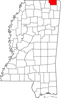
Location of Alcorn County in Mississippi
This is intended to be a complete list of the properties and districts on the National Register of Historic Places in Alcorn County, Mississippi, United States. Latitude and longitude coordinates are provided for many National Register properties and districts; these locations may be seen together in a map.[1]
There are 21 properties and districts listed on the National Register in the county, including 1 National Historic Landmark.
- This National Park Service list is complete through NPS recent listings posted January 29, 2021.[2]
Current listings
| [3] | Name on the Register[4] | Image | Date listed[5] | Location | City or town | Description |
|---|---|---|---|---|---|---|
| 1 | Battery Williams | 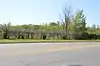 Battery Williams |
April 11, 1977 (#77000783) |
Fulton Dr. at the former Southern railroad line 34°56′03″N 88°31′37″W |
Corinth | (See Siege and Battle of Corinth Sites ) |
| 2 | Battle of Corinth, Confederate Assault Position | 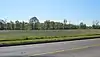 Battle of Corinth, Confederate Assault Position |
April 30, 1976 (#76001088) |
Shiloh Rd. 34°56′35″N 88°31′36″W |
Corinth | (See Siege and Battle of Corinth Sites ) |
| 3 | Dr. Joseph M. Bynum House | November 24, 1997 (#96001268) |
48 S. Front St. 34°45′42″N 88°31′40″W |
Rienzi | ||
| 4 | Coliseum Theatre | 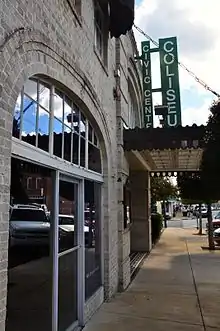 Coliseum Theatre |
August 21, 1980 (#80002199) |
404 Taylor St. 34°56′03″N 88°31′07″W |
Corinth | |
| 5 | Corinth Clothing Manufacturing Company Building | Corinth Clothing Manufacturing Company Building |
November 17, 2004 (#04001241) |
Tate St. at Davis St. 34°55′54″N 88°31′10″W |
Corinth | |
| 6 | Corinth National Cemetery | 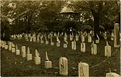 Corinth National Cemetery |
November 20, 1996 (#96001352) |
1551 Horton St. 34°55′35″N 88°30′36″W |
Corinth | (See Siege and Battle of Corinth Sites ) |
| 7 | Thomas F. Dilworth House | September 15, 1988 (#88001463) |
West off U.S. Route 45, south of Biggersville 34°49′41″N 88°35′40″W |
Biggersville | ||
| 8 | Downtown Corinth Historic District | 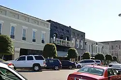 Downtown Corinth Historic District |
January 28, 1993 (#92001792) |
Roughly bounded by Wick, Jackson, Foote and Webster Sts. 34°56′02″N 88°31′11″W |
Corinth | |
| 9 | Federal Siege Trench |  Federal Siege Trench |
November 13, 1976 (#76001089) |
North of Corinth off U.S. Route 45 34°58′40″N 88°30′09″W |
Corinth | (See Siege and Battle of Corinth Sites ) |
| 10 | Fort Robinette | 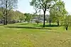 Fort Robinette |
April 11, 1972 (#72000686) |
Robinette St. 34°56′15″N 88°31′42″W |
Corinth | (See Siege and Battle of Corinth Sites ) |
| 11 | Gateway Lanes | May 17, 2019 (#100003949) |
2001 E. Shiloh Rd. 34°56′43″N 88°30′05″W |
Corinth | ||
| 12 | Jacinto Courthouse | 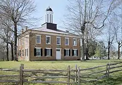 Jacinto Courthouse |
November 25, 1969 (#69000080) |
Route 1 34°45′41″N 88°25′41″W |
Rienzi | |
| 13 | Midtown Corinth Historic District |  Midtown Corinth Historic District |
December 23, 1993 (#93001433) |
Roughly bounded by Cass, Bunch, Washington, Main, Filmore, Linden, Douglas, and Cruise Sts. 34°56′15″N 88°30′57″W |
Corinth | |
| 14 | Moores Creek Site | July 7, 1975 (#75001039) |
Address Restricted |
Rienzi | ||
| 15 | Old US Post Office | 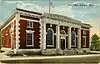 Old US Post Office |
January 29, 1992 (#91002038) |
515 Fillmore St. 34°56′08″N 88°31′14″W |
Corinth | |
| 16 | Rienzi Commercial Historic District | 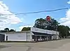 Rienzi Commercial Historic District |
November 7, 1996 (#96001312) |
Junction of Front and Main Sts. 34°45′49″N 88°31′41″W |
Rienzi | Consists of several early 20th century buildings concentrated around the intersection of Main and Front streets |
| 17 | Siege and Battle of Corinth |  Siege and Battle of Corinth |
May 6, 1991 (#91001050) |
Various locations in and around the town of Corinth 34°56′15″N 88°31′09″W |
Corinth | National Historic Landmark district including numerous sites |
| 18 | L.C. Steele House | 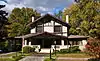 L.C. Steele House |
July 16, 1992 (#92000855) |
515 4th St. 34°56′34″N 88°31′05″W |
Corinth | |
| 19 | Union Battery F, Battle of Corinth | September 10, 1987 (#87001577) |
Rabbitt Ranch Rd. 34°56′53″N 88°33′06″W |
Corinth | (See Siege and Battle of Corinth Sites ) | |
| 20 | Union Earthworks | July 25, 1997 (#97000770) |
0.5 miles northeast of the junction of U.S. Route 45 and Mississippi Highway 356 34°46′02″N 88°32′53″W |
Rienzi | (See Siege and Battle of Corinth Sites ) | |
| 21 | Veranda House |  Veranda House |
August 22, 1975 (#75001038) |
711 Jackson St. 34°56′13″N 88°31′15″W |
Corinth |
See also
| Wikimedia Commons has media related to National Register of Historic Places in Alcorn County, Mississippi. |
References
- The latitude and longitude information provided in this table was derived originally from the National Register Information System, which has been found to be fairly accurate for about 99% of listings. Some locations in this table may have been corrected to current GPS standards.
- "National Register of Historic Places: Weekly List Actions". National Park Service, United States Department of the Interior. Retrieved on January 29, 2021.
- Numbers represent an alphabetical ordering by significant words. Various colorings, defined here, differentiate National Historic Landmarks and historic districts from other NRHP buildings, structures, sites or objects.
- "National Register Information System". National Register of Historic Places. National Park Service. March 13, 2009.
- The eight-digit number below each date is the number assigned to each location in the National Register Information System database, which can be viewed by clicking the number.
| Topics | |
|---|---|
| Lists by state |
|
| Lists by insular areas | |
| Lists by associated state | |
| Other areas | |
| Related | |
| |
Municipalities and communities of Alcorn County, Mississippi, United States | ||
|---|---|---|
| City | Map of Mississippi highlighting Alcorn County | |
| Towns | ||
| Village | ||
| Unincorporated communities | ||
| Ghost town | ||
| ||
This article is issued from Wikipedia. The text is licensed under Creative Commons - Attribution - Sharealike. Additional terms may apply for the media files.