National Register of Historic Places listings in Custer County, Nebraska
This is a list of the National Register of Historic Places listings in Custer County, Nebraska. It is intended to be a complete list of the properties and districts on the National Register of Historic Places in Custer County, Nebraska, United States. The locations of National Register properties and districts for which the latitude and longitude coordinates are included below, may be seen in a map.[1]
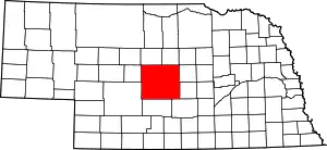
Location of Custer County in Nebraska
There are 14 properties and districts listed on the National Register in the county. Another three sites were once listed but have since been removed.
- This National Park Service list is complete through NPS recent listings posted January 29, 2021.[2]
Listings county-wide
| [3] | Name on the Register | Image | Date listed[4] | Location | City or town | Description |
|---|---|---|---|---|---|---|
| 1 | Arrow Hotel | Arrow Hotel |
September 12, 1985 (#85002145) |
509 S. 9th Ave. 41°24′06″N 99°38′26″W |
Broken Bow | |
| 2 | Brenizer Library | 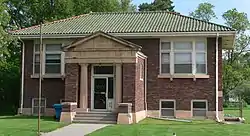 Brenizer Library |
July 3, 2007 (#07000654) |
430 W. Center Ave. 41°29′04″N 99°45′41″W |
Merna | |
| 3 | Broken Bow Carnegie Library | 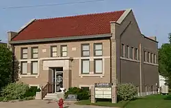 Broken Bow Carnegie Library |
March 5, 1998 (#98000193) |
255 S. 10th St. 41°24′12″N 99°38′30″W |
Broken Bow | |
| 4 | Broken Bow Commercial Square Historic District | 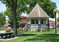 Broken Bow Commercial Square Historic District |
November 21, 2006 (#06001058) |
Five blocks in downtown Broken Bow centered around the public square 41°24′08″N 99°38′25″W |
Broken Bow | |
| 5 | Custer County Courthouse and Jail |  Custer County Courthouse and Jail |
April 19, 1979 (#79001435) |
Courthouse Square, Main St. 41°24′09″N 99°38′32″W |
Broken Bow | |
| 6 | William R. Dowse House |  William R. Dowse House |
December 1, 1986 (#86003365) |
80560 Oak Grove Road[5] 41°30′40″N 99°15′40″W |
Comstock | |
| 7 | Finch Memorial Library | 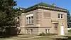 Finch Memorial Library |
July 1, 2015 (#15000392) |
205 N. Walnut St. 41°25′26″N 100°11′40″W |
Arnold | |
| 8 | First Custer County Courthouse | 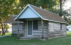 First Custer County Courthouse |
January 10, 1990 (#89002213) |
Pacific St. and Cameron Ave. 41°17′33″N 99°55′22″W |
Callaway | |
| 9 | First National Bank-Steinmeier Building | 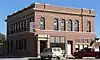 First National Bank-Steinmeier Building |
August 10, 2011 (#11000527) |
624 Main St. 41°17′17″N 99°22′53″W |
Ansley | |
| 10 | Stillman P. Groat House | 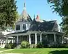 Stillman P. Groat House |
March 24, 2015 (#15000105) |
432 N. 10th Ave.[6] 41°24′32″N 99°38′29″W |
Broken Bow | |
| 11 | Benjamin and Mary Kellenbarger House | _from_NE_1.JPG.webp) Benjamin and Mary Kellenbarger House |
July 3, 2007 (#07000659) |
451 W. Center Ave. 41°29′02″N 99°45′51″W |
Merna | |
| 12 | Mason City School |  Mason City School |
March 2, 2006 (#06000103) |
750 Main St. 41°13′14″N 99°18′02″W |
Mason City | |
| 13 | St. Anselm's Catholic Church, Rectory and Parish Hall | _from_SW_2.JPG.webp) St. Anselm's Catholic Church, Rectory and Parish Hall |
March 12, 2008 (#08000170) |
Nebraska Highway 2 41°36′58″N 99°51′59″W |
Anselmo | |
| 14 | Security State Bank Building | 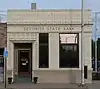 Security State Bank Building |
November 30, 1987 (#87002072) |
403 S. 9th St. 41°24′09″N 99°38′26″W |
Broken Bow |
Former listings
| [3] | Name on the Register | Image | Date listed | Date removed | Location | City or town | Summary |
|---|---|---|---|---|---|---|---|
| 1 | Haumont House | Unknown (#69000368) | January 4, 1973 | NE of Broken Bow |
Broken Bow vicinity | [7] | |
| 2 | Sargent Bridge | 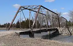 Sargent Bridge |
June 29, 1992 (#92000740) | March 13, 2020 | Dawson St. over the Middle Loup River, 1 mile south of Sargent 41°37′38″N 99°22′18″W |
Sargent | Destroyed by flooding in 2019[8] |
| 3 | Wescott, Gibbons & Bragg Store | January 31, 1978 (#78001694) | March 14, 2007 | Off Nebraska Highway 106 |
Comstock |
See also
References
- The latitude and longitude information provided in this table was derived originally from the National Register Information System, which has been found to be fairly accurate for about 99% of listings. Some locations in this table may have been corrected to current GPS standards.
- "National Register of Historic Places: Weekly List Actions". National Park Service, United States Department of the Interior. Retrieved on January 29, 2021.
- Numbers represent an alphabetical ordering by significant words. Various colorings, defined here, differentiate National Historic Landmarks and historic districts from other NRHP buildings, structures, sites or objects.
- The eight-digit number below each date is the number assigned to each location in the National Register Information System database, which can be viewed by clicking the number.
- Dowse Riverview Homestead & Dowse Sod House. Archived 2010-06-29 at the Wayback Machine www.visitnebraska.gov. Archived 2010-10-11 at the Wayback Machine Retrieved 2010-10-14.
- Cain, Dr. Donald V., and Maureen K. Cain. "National Register of Historic Places Registration Form: Stillman P. Groat House". Nebraska State Historical Society. Retrieved 2015-09-15.
- 38 FR 811 (January 4, 1973)
- Gnuse, Brian (March 18, 2019). "110 Year Old Bridge Destroyed South of Sargent in the Recent Flooding". NTV News. Retrieved June 25, 2019.
External links
| Wikimedia Commons has media related to National Register of Historic Places in Custer County, Nebraska. |
- Nebraska National Register Sites in Custer County–Nebraska State Historical Society
| Topics | |
|---|---|
| Lists by state |
|
| Lists by insular areas | |
| Lists by associated state | |
| Other areas | |
| Related | |
| |
Municipalities and communities of Custer County, Nebraska, United States | ||
|---|---|---|
| Cities | Map of Nebraska highlighting Custer County | |
| Villages | ||
| Townships | ||
| CDP | ||
| Unincorporated communities | ||
| Ghost towns | ||
| ||
This article is issued from Wikipedia. The text is licensed under Creative Commons - Attribution - Sharealike. Additional terms may apply for the media files.