National Register of Historic Places listings in Dawson County, Nebraska
This is a list of the National Register of Historic Places listings in Dawson County, Nebraska.
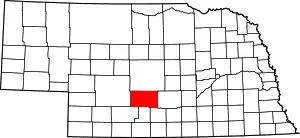
Location of Dawson County in Nebraska
This is intended to be a complete list of the properties and districts on the National Register of Historic Places in Dawson County, Nebraska, United States. The locations of National Register properties and districts for which the latitude and longitude coordinates are included below, may be seen in a map.[1]
There are 10 properties and districts listed on the National Register in the county.
- This National Park Service list is complete through NPS recent listings posted January 29, 2021.[2]
Current listings
| [3] | Name on the Register[4] | Image | Date listed[5] | Location | City or town | Description |
|---|---|---|---|---|---|---|
| 1 | Allen's Opera House | 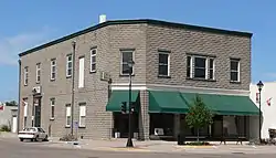 Allen's Opera House |
September 28, 1988 (#88000951) |
100 E. 8th 40°51′35″N 99°59′07″W |
Cozad | part of the Opera House Buildings in Nebraska 1867-1917 Multiple Property Submission |
| 2 | Ernest A. Calling House | _from_E.JPG.webp) Ernest A. Calling House |
October 25, 1979 (#79001437) |
1514 Lake Ave. 40°56′00″N 100°09′36″W |
Gothenburg | |
| 3 | Carnegie Public Library | 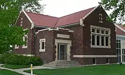 Carnegie Public Library |
December 19, 1986 (#86003443) |
1104 Lake Ave. 40°55′47″N 100°09′37″W |
Gothenburg | |
| 4 | Cozad Downtown Historic District | November 5, 2018 (#100003093) |
Roughly bounded by 9th, 7th, H & F Sts. 40°51′35″N 99°59′09″W |
Cozad | ||
| 5 | Dawson County Courthouse | 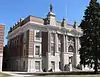 Dawson County Courthouse |
January 10, 1990 (#89002236) |
Washington St. between 7th and 8th Sts. 40°46′49″N 99°44′25″W |
Lexington | part of the County Courthouses of Nebraska Multiple Property Submission |
| 6 | Hendee Hotel | 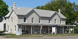 Hendee Hotel |
March 21, 1979 (#79001436) |
220 E. 8th St. 40°51′35″N 99°58′58″W |
Cozad | |
| 7 | Midway Ranch House |  Midway Ranch House |
July 5, 2001 (#01000715) |
Address Restricted |
Gothenburg | |
| 8 | Midway Stage Station | Midway Stage Station |
October 15, 1969 (#69000372) |
South of Gothenburg 40°53′07″N 100°08′51″W |
Gothenburg | |
| 9 | Ira Webster Olive House |  Ira Webster Olive House |
November 27, 1989 (#89002042) |
401 E. 13th St. 40°47′13″N 99°44′10″W |
Lexington | |
| 10 | Harry V. Temple House | November 12, 2019 (#100004608) |
305 E. 13th St. 40°47′12″N 99°44′15″W |
Lexington |
See also
| Wikimedia Commons has media related to National Register of Historic Places in Dawson County, Nebraska. |
References
- The latitude and longitude information provided in this table was derived originally from the National Register Information System, which has been found to be fairly accurate for about 99% of listings. Some locations in this table may have been corrected to current GPS standards.
- "National Register of Historic Places: Weekly List Actions". National Park Service, United States Department of the Interior. Retrieved on January 29, 2021.
- Numbers represent an alphabetical ordering by significant words. Various colorings, defined here, differentiate National Historic Landmarks and historic districts from other NRHP buildings, structures, sites or objects.
- "National Register Information System". National Register of Historic Places. National Park Service. July 9, 2010.
- The eight-digit number below each date is the number assigned to each location in the National Register Information System database, which can be viewed by clicking the number.
| Topics | |
|---|---|
| Lists by state |
|
| Lists by insular areas | |
| Lists by associated state | |
| Other areas | |
| Related | |
| |
Municipalities and communities of Dawson County, Nebraska, United States | ||
|---|---|---|
| Cities | Map of Nebraska highlighting Dawson County | |
| Villages | ||
| CDP | ||
| Unincorporated communities | ||
| Former communities | ||
| ||
This article is issued from Wikipedia. The text is licensed under Creative Commons - Attribution - Sharealike. Additional terms may apply for the media files.