National Register of Historic Places listings in Elko County, Nevada
List of Registered Historic Places in Elko County, Nevada, USA:
The locations of National Register properties and districts (at least for all showing latitude and longitude coordinates below), may be seen in an online map by clicking on "Map of all coordinates".[1]
- This National Park Service list is complete through NPS recent listings posted January 29, 2021.[2]
Current listings
| [3] | Name on the Register | Image | Date listed[4] | Location | City or town | Description |
|---|---|---|---|---|---|---|
| 1 | Elko County Courthouse | 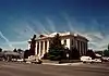 Elko County Courthouse |
September 23, 1992 (#92001259) |
571 Idaho St. 40°50′01″N 115°45′42″W |
Elko | |
| 2 | Gold Creek Ranger Station | 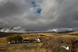 Gold Creek Ranger Station |
September 15, 1992 (#92001187) |
East of Mountain City in the Humboldt National Forest 41°45′04″N 115°40′29″W |
Mountain City | |
| 3 | Lamoille Organization Camp | 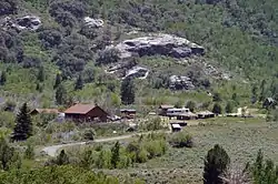 Lamoille Organization Camp |
June 14, 2007 (#07000553) |
Right fork of Lamoille Creek at the end of FS Rd. 122, Ruby Mountains Ranger District, in the Humboldt-Toiyabe National Forest 40°39′25″N 115°26′23″W |
Lamoille | |
| 4 | Midas Schoolhouse | 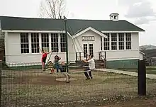 Midas Schoolhouse |
July 21, 2004 (#04000727) |
2nd St., two blocks east of Main St. 41°14′32″N 116°47′39″W |
Midas | |
| 5 | Ruby Valley Pony Express Station | 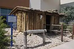 Ruby Valley Pony Express Station |
March 10, 1975 (#75001110) |
1515 Idaho St. 40°50′33″N 115°45′04″W |
Elko | |
| 6 | US Post Office-Elko Main | 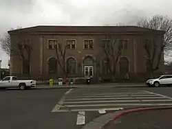 US Post Office-Elko Main |
February 28, 1990 (#90000133) |
275 3rd 40°49′48″N 115°45′47″W |
Elko |
See also
| Wikimedia Commons has media related to National Register of Historic Places in Elko County, Nevada. |
References
- The latitude and longitude information provided in this table was derived originally from the National Register Information System, which has been found to be fairly accurate for about 99% of listings. Some locations in this table may have been corrected to current GPS standards.
- "National Register of Historic Places: Weekly List Actions". National Park Service, United States Department of the Interior. Retrieved on January 29, 2021.
- Numbers represent an alphabetical ordering by significant words. Various colorings, defined here, differentiate National Historic Landmarks and historic districts from other NRHP buildings, structures, sites or objects.
- The eight-digit number below each date is the number assigned to each location in the National Register Information System database, which can be viewed by clicking the number.
| Topics | |
|---|---|
| Lists by state |
|
| Lists by insular areas | |
| Lists by associated state | |
| Other areas | |
| Related | |
| |
This article is issued from Wikipedia. The text is licensed under Creative Commons - Attribution - Sharealike. Additional terms may apply for the media files.