National Register of Historic Places listings in Hancock County, Illinois
This is a list of the National Register of Historic Places listings in Hancock County, Illinois.
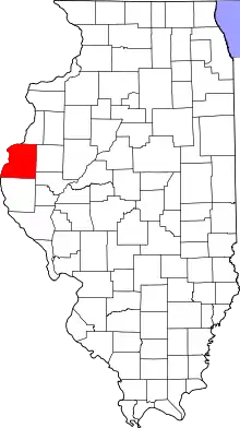
Location of Hancock County in Illinois
This is intended to be a complete list of the properties and districts on the National Register of Historic Places in Hancock County, Illinois, United States. Latitude and longitude coordinates are provided for many National Register properties and districts; these locations may be seen together in a map.[1]
There are 13 properties and districts listed on the National Register in the county.
- This National Park Service list is complete through NPS recent listings posted February 5, 2021.[2]
Current listings
| [3] | Name on the Register | Image | Date listed[4] | Location | City or town | Description |
|---|---|---|---|---|---|---|
| 1 | Cambre House and Farm | 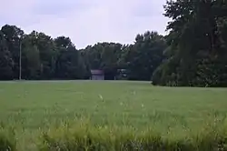 Cambre House and Farm |
November 13, 1984 (#84000308) |
Southwest of Niota 40°35′38″N 91°20′35″W |
Niota | |
| 2 | Carthage Courthouse Square Historic District |  Carthage Courthouse Square Historic District |
August 13, 1986 (#86001482) |
Roughly bounded by Main, Adams, Wabash, and Madison Sts. 40°24′47″N 91°08′08″W |
Carthage | |
| 3 | Carthage Jail | 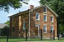 Carthage Jail |
March 20, 1973 (#73000703) |
Walnut and N. Fayette Sts. 40°24′55″N 91°08′22″W |
Carthage | |
| 4 | Cyrus Felt House |  Cyrus Felt House |
March 18, 1980 (#80001366) |
3 miles north of Hamilton 40°26′01″N 91°22′11″W |
Hamilton | |
| 5 | Fort Madison Bridge | 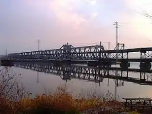 Fort Madison Bridge |
August 27, 1999 (#99001035) |
Iowa Highway 9 over the Mississippi River 40°37′24″N 91°17′32″W |
Niota | A swinging truss toll bridge over the Mississippi River that connects Niota with Fort Madison in Lee County, Iowa |
| 6 | Hunziker Winery Site | November 18, 2019 (#100004624) |
Cedar Glen State Natural Area[5] 40°21′47″N 91°24′48″W |
Warsaw | ||
| 6 | Keokuk Lock and Dam | 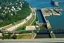 Keokuk Lock and Dam |
October 19, 1978 (#78001234) |
At the Mississippi River 40°23′51″N 91°22′01″W |
Hamilton | A 4,620 feet (1,408.2 m) long dam across the Mississippi River. It includes locks that are 1,200 feet (365.8 m) long and 110 feet (33.5 m) wide. Extends into Lee County, Iowa. |
| 7 | La Harpe City Hall | 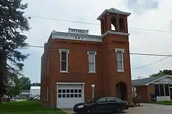 La Harpe City Hall |
November 14, 1991 (#91001689) |
207 E. Main St. 40°35′00″N 90°58′02″W |
La Harpe | |
| 8 | La Harpe Historic District | 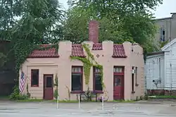 La Harpe Historic District |
April 30, 1987 (#87000031) |
100-124 W. Main St., 100-122 and 101-129 E. Main Sts., 101-121 S. Center St., and City Pk. 40°35′00″N 90°58′10″W |
La Harpe | |
| 9 | Lock and Dam No. 19 Historic District | Lock and Dam No. 19 Historic District |
March 10, 2004 (#04000179) |
West of central Hamilton 40°23′45″N 91°22′32″W |
Hamilton | Historic district that includes 7 buildings, 12 structures, 1 object. Extends into Lee County, Iowa. |
| 10 | Nauvoo Historic District | .jpg.webp) Nauvoo Historic District |
October 15, 1966 (#66000321) |
Nauvoo and its environs 40°33′05″N 91°22′18″W |
Nauvoo | |
| 11 | William J. Reimbold House |  William J. Reimbold House |
December 2, 1987 (#87002033) |
950 White St. 40°32′51″N 91°23′15″W |
Nauvoo | |
| 12 | Warsaw Historic District | 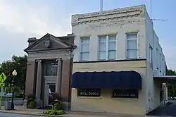 Warsaw Historic District |
December 16, 1977 (#77000486) |
Roughly bounded by the Mississippi River, Marion and 11th Sts. 40°21′48″N 91°26′07″W |
Warsaw |
References
- The latitude and longitude information provided in this table was derived originally from the National Register Information System, which has been found to be fairly accurate for about 99% of listings. Some locations in this table may have been corrected to current GPS standards.
- "National Register of Historic Places: Weekly List Actions". National Park Service, United States Department of the Interior. Retrieved on February 5, 2021.
- Numbers represent an alphabetical ordering by significant words. Various colorings, defined here, differentiate National Historic Landmarks and historic districts from other NRHP buildings, structures, sites or objects.
- The eight-digit number below each date is the number assigned to each location in the National Register Information System database, which can be viewed by clicking the number.
- https://www2.illinois.gov/dnrhistoric/Preserve/SiteAssets/Pages/illinois-historic-sites-advisory-council/Warsaw%20--%20Hunziker%20Winery%20Site.pdf
See also
| Wikimedia Commons has media related to National Register of Historic Places in Hancock County, Illinois. |
- List of National Historic Landmarks in Illinois
- National Register of Historic Places listings in Illinois
| Topics | |
|---|---|
| Lists by state |
|
| Lists by insular areas | |
| Lists by associated state | |
| Other areas | |
| Related | |
| |
This article is issued from Wikipedia. The text is licensed under Creative Commons - Attribution - Sharealike. Additional terms may apply for the media files.