National Register of Historic Places listings in Harding County, South Dakota
This is a list of the National Register of Historic Places listings in Harding County, South Dakota.
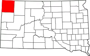
Location of Harding County in South Dakota
This is intended to be a complete list of the properties on the National Register of Historic Places in Harding County, South Dakota, United States. The locations of National Register properties for which the latitude and longitude coordinates are included below, may be seen in a map.[1]
There are 56 properties listed on the National Register in the county.
- This National Park Service list is complete through NPS recent listings posted January 29, 2021.[2]
Current listings
| [3] | Name on the Register[4] | Image | Date listed[5] | Location | City or town | Description |
|---|---|---|---|---|---|---|
| 1 | Archeological Site No. 39HN1 |  Archeological Site No. 39HN1 |
March 7, 1994 (#94000108) |
Address Restricted |
Ludlow | |
| 2 | Archeological Site No. 39HN5 | Archeological Site No. 39HN5 |
March 7, 1994 (#94000109) |
Address Restricted |
Ludlow | |
| 3 | Archeological Site No. 39HN17 | Archeological Site No. 39HN17 |
August 6, 1993 (#93000805) |
Address Restricted |
Ludlow | |
| 4 | Archeological Site No. 39HN18 | Archeological Site No. 39HN18 |
March 7, 1994 (#94000088) |
Address Restricted |
Ludlow | |
| 5 | Archeological Site No. 39HN21 | Archeological Site No. 39HN21 |
March 7, 1994 (#94000124) |
Address Restricted |
Ludlow | |
| 6 | Archeological Site No. 39HN22 | Archeological Site No. 39HN22 |
March 7, 1994 (#94000123) |
Address Restricted |
Ludlow | |
| 7 | Archeological Site No. 39HN26 | Archeological Site No. 39HN26 |
March 7, 1994 (#94000122) |
Address Restricted |
Ludlow | |
| 8 | Archeological Site No. 39HN30 | Archeological Site No. 39HN30 |
March 7, 1994 (#94000121) |
Address Restricted |
Ludlow | |
| 9 | Archeological Site No. 39HN50 | Archeological Site No. 39HN50 |
March 7, 1994 (#94000119) |
Address Restricted |
Ludlow | |
| 10 | Archeological Site No. 39HN53 | Archeological Site No. 39HN53 |
March 7, 1994 (#94000118) |
Address Restricted |
Ludlow | |
| 11 | Archeological Site No. 39HN54 | Archeological Site No. 39HN54 |
March 7, 1994 (#94000120) |
Address Restricted |
Ludlow | |
| 12 | Archeological Site No. 39HN121 | Archeological Site No. 39HN121 |
March 7, 1994 (#94000117) |
Address Restricted |
Ludlow | |
| 13 | Archeological Site No. 39HN150 | Archeological Site No. 39HN150 |
March 7, 1994 (#94000114) |
Address Restricted |
Ludlow | |
| 14 | Archeological Site No. 39HN155 | Archeological Site No. 39HN155 |
March 7, 1994 (#94000115) |
Address Restricted |
Ludlow | |
| 15 | Archeological Site No. 39HN159 | Archeological Site No. 39HN159 |
March 7, 1994 (#94000116) |
Address Restricted |
Ludlow | |
| 16 | Archeological Site No. 39HN160 | Archeological Site No. 39HN160 |
March 7, 1994 (#94000113) |
Address Restricted |
Ludlow | |
| 17 | Archeological Site No. 39HN162 | Archeological Site No. 39HN162 |
March 7, 1994 (#94000091) |
Address Restricted |
Ludlow | |
| 18 | Archeological Site No. 39HN165 | Archeological Site No. 39HN165 |
March 7, 1994 (#94000093) |
Address Restricted |
Ludlow | |
| 19 | Archeological Site No. 39HN167 | Archeological Site No. 39HN167 |
March 7, 1994 (#94000092) |
Address Restricted |
Ludlow | |
| 20 | Archeological Site No. 39HN168 | Archeological Site No. 39HN168 |
March 7, 1994 (#94000129) |
Address Restricted |
Ludlow | |
| 21 | Archeological Site No. 39HN171 | Archeological Site No. 39HN171 |
March 7, 1994 (#94000128) |
Address Restricted |
Ludlow | |
| 22 | Archeological Site No. 39HN174 | Archeological Site No. 39HN174 |
March 7, 1994 (#94000127) |
Address Restricted |
Ludlow | |
| 23 | Archeological Site No. 39HN177 | Archeological Site No. 39HN177 |
March 7, 1994 (#94000126) |
Address Restricted |
Ludlow | |
| 24 | Archeological Site No. 39HN198 | Archeological Site No. 39HN198 |
March 7, 1994 (#94000125) |
Address Restricted |
Ludlow | |
| 25 | Archeological Site No. 39HN199 | Archeological Site No. 39HN199 |
March 7, 1994 (#94000110) |
Address Restricted |
Ludlow | |
| 26 | Archeological Site No. 39HN205 | Archeological Site No. 39HN205 |
March 7, 1994 (#94000095) |
Address Restricted |
Ludlow | |
| 27 | Archeological Site No. 39HN207 | Archeological Site No. 39HN207 |
March 7, 1994 (#94000094) |
Address Restricted |
Ludlow | |
| 28 | Archeological Site No. 39HN208 | Archeological Site No. 39HN208 |
August 6, 1993 (#93000794) |
Address Restricted |
Ludlow | |
| 29 | Archeological Site No. 39HN209 | Archeological Site No. 39HN209 |
March 7, 1994 (#94000107) |
Address Restricted |
Ludlow | |
| 30 | Archeological Site No. 39HN210 | Archeological Site No. 39HN210 |
March 7, 1994 (#94000106) |
Address Restricted |
Ludlow | |
| 31 | Archeological Site No. 39HN213 | Archeological Site No. 39HN213 |
March 7, 1994 (#94000105) |
Address Restricted |
Ludlow | |
| 32 | Archeological Site No. 39HN217 | Archeological Site No. 39HN217 |
March 7, 1994 (#94000104) |
Address Restricted |
Ludlow | |
| 33 | Archeological Site No. 39HN218 | Archeological Site No. 39HN218 |
March 7, 1994 (#94000103) |
Address Restricted |
Ludlow | |
| 34 | Archeological Site No. 39HN219 | Archeological Site No. 39HN219 |
March 7, 1994 (#94000102) |
Address Restricted |
Ludlow | |
| 35 | Archeological Site No. 39HN227 | Archeological Site No. 39HN227 |
March 7, 1994 (#94000111) |
Address Restricted |
Ludlow | |
| 36 | Archeological Site No. 39HN228 | Archeological Site No. 39HN228 |
March 7, 1994 (#94000112) |
Address Restricted |
Ludlow | |
| 37 | Archeological Site No. 39HN232 | Archeological Site No. 39HN232 |
March 7, 1994 (#94000101) |
Address Restricted |
Ludlow | |
| 38 | Archeological Site No. 39HN234 | Archeological Site No. 39HN234 |
March 7, 1994 (#94000100) |
Address Restricted |
Ludlow | |
| 39 | Archeological Site No. 39HN484 | Archeological Site No. 39HN484 |
March 7, 1994 (#94000098) |
Address Restricted |
Ludlow | |
| 40 | Archeological Site No. 39HN485 | Archeological Site No. 39HN485 |
March 7, 1994 (#94000099) |
Address Restricted |
Ludlow | |
| 41 | Archeological Site No. 39HN486 | Archeological Site No. 39HN486 |
March 7, 1994 (#94000097) |
Address Restricted |
Ludlow | |
| 42 | Archeological Site No. 39HN487 | Archeological Site No. 39HN487 |
March 7, 1994 (#94000096) |
Address Restricted |
Ludlow | |
| 43 | Thomas Ashcroft Ranch | April 10, 1987 (#87000547) |
Floodplain of the South Fork of the Grand River, east-northeast of Buffalo 45°40′21″N 103°14′24″W |
Buffalo | ||
| 44 | Blake Ranch House | April 10, 1987 (#87000534) |
1 mile west of Camp Crook Rd. 45°20′44″N 103°57′17″W |
Gustave | ||
| 45 | Emmanuel Lutheran Church and Cemetery | April 10, 1987 (#87000531) |
County Road 858 45°50′05″N 103°11′28″W |
Ralph | ||
| 46 | Fowler Hotel | September 12, 2008 (#08000886) |
103 1st St. SW 45°34′54″N 103°32′46″W |
Buffalo | ||
| 47 | Giannonatti Ranch | April 10, 1987 (#87000546) |
Southern side of an E-W Section Rd. 45°49′27″N 103°15′14″W |
Ludlow | ||
| 48 | Golden Valley Norwegian Lutheran Church | 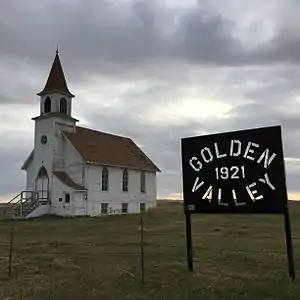 Golden Valley Norwegian Lutheran Church |
April 10, 1987 (#87000548) |
N-S Section Rd. east of Highway 79 45°53′06″N 102°56′33″W |
Ralph | |
| 49 | Axel Johnson Ranch | May 19, 1987 (#87000541) |
East of Highway 79 on Sorum Rd. 45°27′46″N 103°02′00″W |
Reva | ||
| 50 | Lightning Spring (39HN204) | Lightning Spring (39HN204) |
August 2, 1982 (#82003930) |
Address Restricted |
Ludlow | |
| 51 | Little Missouri Bank Building | April 10, 1987 (#87000536) |
Main St. 45°33′01″N 103°58′28″W |
Camp Crook | ||
| 52 | John and Daisy May Livingston Ranch | April 10, 1987 (#87000542) |
East of Highway 79 on the southern side of Sorum Rd. 45°25′17″N 103°02′01″W |
Sorum | ||
| 53 | Peace Valley Evangelical Church and Cemetery | April 10, 1987 (#87000550) |
Eastern side of Highway 79 45°50′12″N 102°58′59″W |
Ralph | ||
| 54 | L.W. Shevling Ranch | April 10, 1987 (#87000537) |
East of Harding in the West Short Pine Hills area 45°23′57″N 103°49′33″W |
Harding | ||
| 55 | Oliver O. Stokes House | April 10, 1987 (#87000532) |
Harding Rd. 45°23′49″N 103°50′00″W |
Harding | 1899-built house was first frame house in the county. | |
| 56 | Vessey School | April 10, 1987 (#87000553) |
County Road 859 45°54′29″N 103°07′37″W |
Haley |
See also
| Wikimedia Commons has media related to National Register of Historic Places in Harding County, South Dakota. |
References
- The latitude and longitude information provided in this table was derived originally from the National Register Information System, which has been found to be fairly accurate for about 99% of listings. Some locations in this table may have been corrected to current GPS standards.
- "National Register of Historic Places: Weekly List Actions". National Park Service, United States Department of the Interior. Retrieved on January 29, 2021.
- Numbers represent an alphabetical ordering by significant words. Various colorings, defined here, differentiate National Historic Landmarks and historic districts from other NRHP buildings, structures, sites or objects.
- "National Register Information System". National Register of Historic Places. National Park Service. April 24, 2008.
- The eight-digit number below each date is the number assigned to each location in the National Register Information System database, which can be viewed by clicking the number.
| Topics | |
|---|---|
| Lists by state |
|
| Lists by insular areas | |
| Lists by associated state | |
| Other areas | |
| Related | |
| |
Municipalities and communities of Harding County, South Dakota, United States | ||
|---|---|---|
| Towns | | |
| Unincorporated communities | ||
| Ghost towns | ||
| ||
This article is issued from Wikipedia. The text is licensed under Creative Commons - Attribution - Sharealike. Additional terms may apply for the media files.