National Register of Historic Places listings in Hinds County, Mississippi
This is a list of the National Register of Historic Places listings in Hinds County, Mississippi.
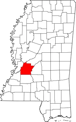
Location of Hinds County in Mississippi
This is intended to be a complete list of the properties and districts on the National Register of Historic Places in Hinds County, Mississippi, United States. Latitude and longitude coordinates are provided for many National Register properties and districts; these locations may be seen together in a map.[1]
There are 112 properties and districts listed on the National Register in the county, including 5 National Historic Landmarks. Another 4 properties were once listed but have been removed.
- This National Park Service list is complete through NPS recent listings posted January 29, 2021.[2]
Current listings
| [3] | Name on the Register[4] | Image | Date listed[5] | Location | City or town | Description |
|---|---|---|---|---|---|---|
| 1 | Admiral Benbow Inn | September 18, 2020 (#100005613) |
905 North State St. 32°18′37″N 90°10′42″W |
Jackson | ||
| 2 | Ayer Hall | 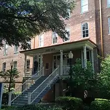 Ayer Hall |
July 14, 1977 (#77000788) |
1400 Lynch St. on the Jackson State University campus 32°17′45″N 90°12′27″W |
Jackson | |
| 3 | Bailey Hill Civil War Earthworks | .jpg.webp) Bailey Hill Civil War Earthworks |
May 6, 1975 (#75001044) |
Off U.S. Route 51 32°16′27″N 90°11′57″W |
Jackson | |
| 4 | Baldwin's Ferry Mound | September 24, 1998 (#98001158) |
Address Restricted |
Newman | ||
| 5 | Bardin Mound (22-Hi-537) | March 1, 1987 (#87000130) |
Address Restricted |
Coxs Ferry | ||
| 6 | Belhaven Heights Historic District |  Belhaven Heights Historic District |
November 25, 1983 (#83003958) |
Bellevue Place, N. Jefferson, Madison, and Morningside Sts.; also roughly bounded by Fortification, North, Monroe, and Spenglar Sts. 32°18′33″N 90°10′28″W |
Jackson | Second set of boundaries represents a boundary increase of September 3, 1998 |
| 7 | Belhaven Historic District |  Belhaven Historic District |
December 19, 2012 (#12000920) |
Roughly bounded by E. Fortification, & N. State Sts., I-55, & Riverside Dr. 32°19′03″N 90°10′04″W |
Jackson | |
| 8 | Bellevue Court Apartments |  Bellevue Court Apartments |
November 21, 1994 (#94001336) |
950 North St. 32°18′39″N 90°10′33″W |
Jackson | |
| 9 | Berry Mound and Village Archeological Site | November 25, 1969 (#69000088) |
Address Restricted |
Terry | ||
| 10 | Big Black River Battlefield | .jpg.webp) Big Black River Battlefield |
November 23, 1971 (#71000451) |
On both banks of the Big Black River between Smith's Station and Bovina 32°21′36″N 90°43′35″W |
Smith's Station | Site of the Battle of Big Black River Bridge; extends into Warren County |
| 11 | Big Black River Railroad Bridge |  Big Black River Railroad Bridge |
November 16, 1988 (#88002418) |
Spans the Big Black River east of Bovina 32°20′49″N 90°42′17″W |
Edwards | Extends into Warren County |
| 12 | Lillian Boteler House | July 15, 1986 (#86001703) |
214 Port Gibson Rd. 32°15′28″N 90°25′27″W |
Raymond | ||
| 13 | Byram Bridge | 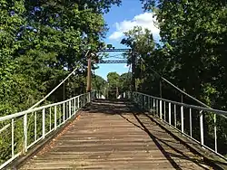 Byram Bridge |
May 23, 1979 (#79003427) |
Old Byram and Florence Rd. 32°10′35″N 90°14′37″W |
Byram | Extends into Rankin County |
| 14 | Calvary Baptist Church | _Front2.jpg.webp) Calvary Baptist Church |
May 14, 2013 (#13000301) |
1300 W. Capitol St. 32°18′31″N 90°12′09″W |
Jackson | |
| 15 | Capitol Green | .jpg.webp) Capitol Green |
November 25, 1969 (#69000083) |
Bounded on the north by Amite St., on the south by Pearl St., on the west by State St., and on the east by the Gulf, Mobile and Ohio railroad line 32°17′56″N 90°10′47″W |
Jackson | The green includes the War Memorial Building, and a Confederate memorial. |
| 16 | Casey Elementary School | January 25, 2018 (#100002029) |
2101 Lake Cir. 32°20′36″N 90°08′28″W |
Jackson | ||
| 17 | Castle Crest | 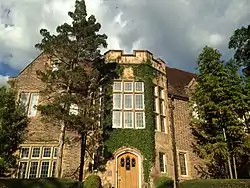 Castle Crest |
March 22, 2010 (#10000131) |
114 Woodland Circle 32°20′10″N 90°10′13″W |
Jackson | |
| 18 | John F. Cates House | .jpg.webp) John F. Cates House |
May 16, 1985 (#85001076) |
Mississippi Highway 22 32°27′06″N 90°25′13″W |
Brownsville | |
| 19 | The Cedars | _Side.jpg.webp) The Cedars |
January 4, 1977 (#77000787) |
405 E. College St. 32°20′14″N 90°19′26″W |
Clinton | |
| 20 | Central Fire Station | .jpg.webp) Central Fire Station |
October 30, 1975 (#75001045) |
S. President St. 32°17′53″N 90°10′55″W |
Jackson | |
| 21 | Chambliss Building | 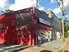 Chambliss Building |
March 22, 2004 (#04000219) |
932 Lynch St. 32°17′57″N 90°12′03″W |
Jackson | |
| 22 | Champion Hill Battlefield | 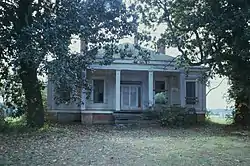 Champion Hill Battlefield |
October 7, 1971 (#71000450) |
4 miles southwest of Bolton 32°19′12″N 90°32′33″W |
Bolton | |
| 23 | City Hall |  City Hall |
November 25, 1969 (#69000084) |
203 S. President St. 32°17′52″N 90°10′56″W |
Jackson | |
| 24 | City Mound (22Hi672) | December 1, 1988 (#88002703) |
Address Restricted |
Jackson | ||
| 25 | Clinton Olde Towne Historic District | January 12, 2017 (#100000537) |
Bounded by Belmont, East, College & Capitol/West Sts. 32°20′22″N 90°19′50″W |
Clinton | ||
| 26 | Downtown Fondren Historic District | .jpg.webp) Downtown Fondren Historic District |
September 10, 2014 (#14000566) |
Roughly along N. State St., Old Canton Rd., Duling Ave. & Fondren Pl. 32°20′07″N 90°10′32″W |
Jackson | |
| 27 | Dupree House | January 31, 1979 (#79001314) |
West of Raymond on Dupree Rd. 32°15′21″N 90°30′25″W |
Raymond | ||
| 28 | Dupree Mound and Village Archeological Site | November 25, 1969 (#69000082) |
Address Restricted |
Edwards | ||
| 29 | Dupree-Ratliff House | 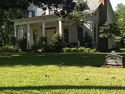 Dupree-Ratliff House |
July 15, 1986 (#86001704) |
101 Dupree St. 32°15′43″N 90°25′33″W |
Raymond | |
| 30 | East Clinton Historic District | .jpg.webp) East Clinton Historic District |
July 11, 1997 (#97000631) |
Roughly bounded by the Illinois Central railroad tracks, E. College, Landrum, E. Main, and New Prospect Sts. 32°20′16″N 90°19′50″W |
Clinton | |
| 31 | Edwards Hotel | .jpg.webp) Edwards Hotel |
November 7, 1976 (#76001096) |
Capitol and Mill Sts. 32°17′59″N 90°11′25″W |
Jackson | |
| 32 | Medgar Evers Historic District | .jpg.webp) Medgar Evers Historic District |
September 18, 2013 (#13000737) |
Roughly Margaret Walker Alexander St., W. of Missouri & E. of Miami Sts. 32°20′27″N 90°12′39″W |
Jackson | |
| 33 | Medgar Evers House | 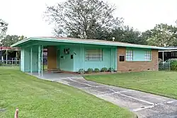 Medgar Evers House |
December 5, 2000 (#00001459) |
2332 Margaret Walker Alexander Dr. 32°20′27″N 90°12′46″W |
Jackson | |
| 34 | Farish Street Neighborhood Historic District |  Farish Street Neighborhood Historic District |
March 13, 1980 (#80002245) |
Roughly bounded by Amite, Mill, Fortification, and Lamar Sts.; also roughly bounded by Amite, Lamar, Mill and Fortification Sts. 32°18′24″N 90°11′16″W |
Jackson | Second set of boundaries represents a boundary increase of September 18, 1980 |
| 35 | Floyd Mound | November 25, 1969 (#69000081) |
Address Restricted |
Bovina | ||
| 36 | Fountainhead |  Fountainhead |
November 28, 1980 (#80002246) |
306 Glen Way 32°20′09″N 90°10′08″W |
Jackson | |
| 37 | James M. Futch House | March 12, 1992 (#92000144) |
Dry Grove Rd., 1½ miles south of its junction with Mississippi Highway 18 32°13′09″N 90°25′31″W |
Raymond | The structure was purchased in 1993 and relocated nine miles northeast on Dupree Rd to save it from demolition. It has been restore as a private dwelling. | |
| 38 | Galloway-Williams House |  Galloway-Williams House |
October 10, 1985 (#85003100) |
427 E. Fortification St. 32°18′42″N 90°10′50″W |
Jackson | |
| 39 | George Street Grocery | 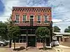 George Street Grocery |
July 8, 2010 (#10000438) |
416 George St. 32°18′23″N 90°10′55″W |
Jackson | |
| 40 | Gibbs-Von Seutter House | 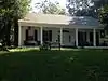 Gibbs-Von Seutter House |
July 15, 1986 (#86001705) |
Southern side of Dupree St. 32°15′42″N 90°25′33″W |
Raymond | |
| 41 | Garner Wynn Green House |  Garner Wynn Green House |
October 31, 1985 (#85003440) |
647 N. State St. 32°18′20″N 90°10′45″W |
Jackson | |
| 42 | Greenwood Cemetery | Greenwood Cemetery |
December 20, 1984 (#84000474) |
Bounded by West, Davis, Lamar, and George Sts. 32°18′30″N 90°11′00″W |
Jackson | |
| 43 | R.H. Henry Bridge | .jpg.webp) R.H. Henry Bridge |
June 8, 2005 (#05000563) |
U.S. Route 80 at the Big Black River 32°20′51″N 90°41′49″W |
Edwards | |
| 44 | Hinds County Armory | Hinds County Armory |
December 1, 2000 (#00001462) |
1012 Mississippi St. 32°18′07″N 90°10′27″W |
Jackson | |
| 45 | Hinds County Courthouse | .jpg.webp) Hinds County Courthouse |
July 31, 1986 (#86002125) |
Pascagoula St. 32°17′48″N 90°10′58″W |
Jackson | |
| 46 | Hinds County Courthouse |  Hinds County Courthouse |
July 15, 1986 (#86001706) |
E. Main and N. Oak Sts. 32°15′37″N 90°25′24″W |
Raymond | |
| 47 | Holly Grove Plantation House | 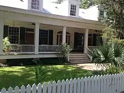 Holly Grove Plantation House |
November 7, 1996 (#96001313) |
1056 Old Bridgeport Rd. 32°23′25″N 90°25′04″W |
Bolton | |
| 48 | Houses at 500, 505, 512 and 513 North State Street | 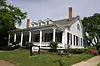 Houses at 500, 505, 512 and 513 North State Street |
November 7, 1995 (#95001249) |
500, 505, 512, and 513 N. State St. 32°18′13″N 90°10′45″W |
Jackson | |
| 49 | Illinois Central Railroad Depot | 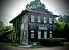 Illinois Central Railroad Depot |
July 15, 1986 (#86001707) |
E. Main and Railroad Sts. 32°15′30″N 90°25′18″W |
Raymond | |
| 50 | Illinois Central Railroad Depot | 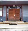 Illinois Central Railroad Depot |
November 5, 2001 (#01001200) |
102 Railroad Ave. 32°05′42″N 90°17′35″W |
Terry | |
| 51 | Dudley Jones House | .jpg.webp) Dudley Jones House |
August 2, 1984 (#84002218) |
115 Railroad Ave. 32°05′42″N 90°17′41″W |
Terry | |
| 52 | Keith Press Building |  Keith Press Building |
July 15, 1986 (#86001708) |
234 Town Sq. 32°15′35″N 90°25′21″W |
Raymond | |
| 53 | Lanier Junior-Senior High School (Colored) | _(2).jpg.webp) Lanier Junior-Senior High School (Colored) |
September 10, 2014 (#14000567) |
833 Maple St. 32°18′59″N 90°12′10″W |
Jackson | |
| 54 | Lebanon Presbyterian Church | 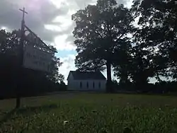 Lebanon Presbyterian Church |
November 18, 1999 (#99001359) |
Lebanon Presbyterian Church Rd. 32°08′55″N 90°31′22″W |
Utica | |
| 55 | A.J. Lewis House | 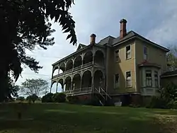 A.J. Lewis House |
August 4, 1983 (#83000952) |
S. Magnolia and Lewis Sts. 32°19′48″N 90°36′14″W |
Edwards | |
| 56 | Ervin Lewis House | 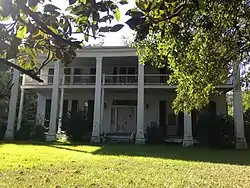 Ervin Lewis House |
December 1, 1989 (#89002052) |
5461 Old Byram Rd. 32°10′52″N 90°14′36″W |
Byram | |
| 57 | Liberty Hall | _front.jpg.webp) Liberty Hall |
March 19, 2008 (#08000197) |
22822 Mississippi Highway 27 32°03′43″N 90°29′06″W |
Crystal Springs | |
| 58 | Lorena Duling School | Lorena Duling School |
July 3, 2007 (#07000650) |
622 Duling Ave. 32°20′11″N 90°10′33″W |
Jackson | |
| 59 | Magnolia Vale | 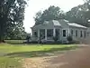 Magnolia Vale |
November 17, 1983 (#83003960) |
Off Mississippi Highway 18 32°12′17″N 90°28′24″W |
Raymond | |
| 60 | Main Hall |  Main Hall |
July 15, 1986 (#86001709) |
Northwest of Cain Hall 32°15′19″N 90°25′02″W |
Raymond | |
| 61 | Manship House | 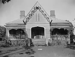 Manship House |
October 18, 1972 (#72000693) |
412 E. Fortification St. 32°18′45″N 90°10′53″W |
Jackson | |
| 62 | McNair Plantation | 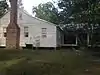 McNair Plantation |
May 3, 1982 (#82003101) |
Southeast of Raymond on Mississippi Highway 18 32°10′19″N 90°30′30″W |
Raymond | |
| 63 | McRae's Department Store at Meadowbrook Mart |  McRae's Department Store at Meadowbrook Mart |
March 3, 2015 (#14000568) |
4206 N. State St. 32°20′59″N 90°10′26″W |
Jackson | |
| 64 | Merrill-Maley House | 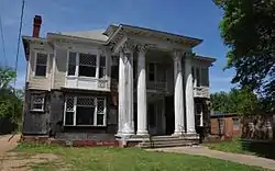 Merrill-Maley House |
April 29, 1982 (#82003100) |
739 N. State St. 32°18′27″N 90°10′44″W |
Jackson | |
| 65 | Millsaps-Buie House | 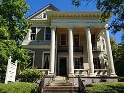 Millsaps-Buie House |
June 19, 1973 (#73001014) |
628 N. State St. 32°18′18″N 90°10′43″W |
Jackson | |
| 66 | Mississippi Federation of Women's Clubs | 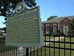 Mississippi Federation of Women's Clubs |
June 30, 1988 (#88000975) |
2407 N. State St. 32°19′37″N 90°10′33″W |
Jackson | |
| 67 | Mississippi Foundry and Machine Company Building |  Mississippi Foundry and Machine Company Building |
July 16, 2008 (#08000674) |
300 W. South St. 32°20′25″N 90°10′02″W |
Jackson | |
| 68 | Mississippi Governor's Mansion | .jpg.webp) Mississippi Governor's Mansion |
November 25, 1969 (#69000085) |
316 E. Capitol St. 32°18′00″N 90°11′00″W |
Jackson | |
| 69 | Mississippi State Capitol | .jpg.webp) Mississippi State Capitol |
November 25, 1969 (#69000086) |
Fronting Mississippi St., between N. President and N. West Sts. 32°18′56″N 90°11′49″W |
Jackson | The "New Capitol" building, built in 1903; designated a National Historic Landmark in 2016. |
| 70 | Morris Ice Company | May 16, 2019 (#100003950) |
652 Commerce St. 32°17′33″N 90°10′49″W |
Jackson | ||
| 71 | Joseph Henry Morris House | 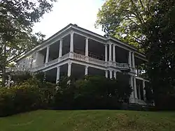 Joseph Henry Morris House |
August 11, 1983 (#83000953) |
305 N. State St. 32°18′13″N 90°10′47″W |
Jackson | |
| 72 | Mt. Olive Cemetery | June 5, 2017 (#100001028) |
900 blk. of John R. Lynch St. 32°17′51″N 90°12′10″W |
Jackson | ||
| 73 | Municipal Art Gallery | 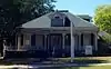 Municipal Art Gallery |
March 27, 2012 (#12000154) |
839 N. State St. 32°18′36″N 90°10′43″W |
Jackson | |
| 74 | N&W Overall Company Building |  N&W Overall Company Building |
November 14, 2007 (#07001180) |
736 S. President St. 32°17′33″N 90°10′58″W |
Jackson | |
| 75 | Naval and Marine Corps Reserve Center | Naval and Marine Corps Reserve Center |
November 19, 2002 (#02000209) |
181 S. Jefferson St. 32°18′00″N 90°10′42″W |
Jackson | |
| 76 | New Orleans Great Northern Railroad Passenger Depot | 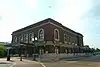 New Orleans Great Northern Railroad Passenger Depot |
March 1, 1996 (#96000188) |
618 Pearl St. 32°17′54″N 90°10′45″W |
Jackson | |
| 77 | North Manor Apartments | .jpg.webp) North Manor Apartments |
March 3, 1995 (#95000177) |
909 North St. 32°18′37″N 90°10′37″W |
Jackson | |
| 78 | The Oaks | 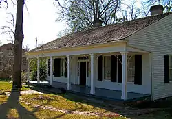 The Oaks |
May 25, 1973 (#73001015) |
823 N. Jefferson St. 32°18′32″N 90°10′34″W |
Jackson | |
| 79 | Old State Capitol | .jpg.webp) Old State Capitol |
November 25, 1969 (#69000087) |
100 N. State St. 32°17′57″N 90°10′48″W |
Jackson | |
| 80 | Old Terminal Building, Hawkins Field | September 9, 2020 (#100005578) |
Airport Dr. 32°19′41″N 90°13′00″W |
Jackson | ||
| 81 | Peyton House | 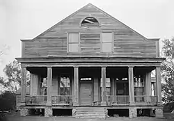 Peyton House |
October 3, 1973 (#73001016) |
North of Raymond on Clinton Rd. 32°16′01″N 90°25′12″W |
Raymond | |
| 82 | Phoenix Hall-Johnson-Harper House | 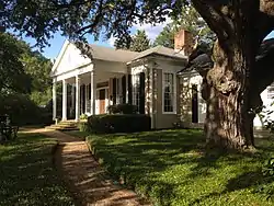 Phoenix Hall-Johnson-Harper House |
July 15, 1986 (#86001710) |
527 E. Palestine St. 32°15′12″N 90°25′09″W |
Raymond | |
| 83 | Pocahontas Mound A | 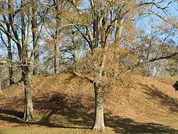 Pocahontas Mound A |
November 25, 1969 (#69000365) |
In a park along U.S. Route 49, near its junction with Interstate 220[6] 32°28′09″N 90°17′18″W |
Pocahontas | |
| 84 | Pocahontas Mound B | April 11, 1972 (#72000694) |
Address Restricted |
Pocahontas | ||
| 85 | Poindexter Park Historic District | .jpg.webp) Poindexter Park Historic District |
June 9, 1995 (#95000685) |
Roughly bounded by W. Pearl St., Rose St., Hunt St., W. Capitol St., and Clifton St. 32°18′06″N 90°11′53″W |
Jackson | |
| 86 | Porter House | .jpg.webp) Porter House |
July 15, 1986 (#86001702) |
233 North Oak St. 32°15′41″N 90°25′21″W |
Raymond | |
| 87 | Raymond Battlefield Site |  Raymond Battlefield Site |
January 13, 1972 (#72000695) |
2.5 miles southwest of Raymond on Mississippi Highway 18 32°14′30″N 90°27′00″W |
Raymond | Site of the Battle of Raymond |
| 88 | Raymond Historic District |  Raymond Historic District |
July 27, 2007 (#07000749) |
Roughly Town Sq., with parts of E. Main, Palestine, Cooper's Well, Clinton, Oak, Court, W. Main, Dupree, and Port Gibson 32°15′34″N 90°25′22″W |
Raymond | |
| 89 | Smith Robertson Elementary School | .jpg.webp) Smith Robertson Elementary School |
December 13, 1978 (#78001601) |
528 Bloom St. 32°18′19″N 90°11′11″W |
Jackson | |
| 90 | Saint Mark's Episcopal Church | 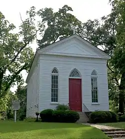 Saint Mark's Episcopal Church |
July 15, 1986 (#86001712) |
W. Main and N. Oak Sts. 32°15′38″N 90°25′26″W |
Raymond | |
| 91 | Shelton House | 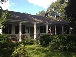 Shelton House |
July 15, 1986 (#86001711) |
561 W. Main St. 32°16′00″N 90°25′40″W |
Raymond | |
| 92 | Sims House | 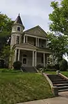 Sims House |
March 31, 1983 (#83000954) |
513 N. State St. 32°18′14″N 90°10′46″W |
Jackson | |
| 93 | Smith Apartments | July 20, 2020 (#100005036) |
1047 Smith Dr. 32°15′02″N 90°26′15″W |
Raymond | ||
| 94 | Smith Park Architectural District |  Smith Park Architectural District |
April 23, 1976 (#76001097) |
Irregular pattern along N. West and N. Congress Sts. between Capitol St. and the state capitol; also 225 E. Capitol St.; also 308 E. Pearl St.; also 200 blk. E. Capitol St. 32°18′02″N 90°11′00″W |
Jackson | Capitol and Pearl addresses represent boundary increases of October 29, 1993 and March 24, 2004 respectively; a third boundary increase was listed July 25, 2014 |
| 95 | Southern Christian Institute | 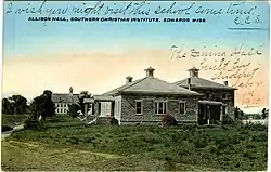 Southern Christian Institute |
January 30, 2007 (#06001323) |
18449 Old U.S. Route 80, W. 32°20′17″N 90°38′16″W |
Edwards | |
| 96 | Southwest Midtown Historic District | October 4, 2019 (#100004504) |
Roughly bounded by Whitfield St., Blair St., East Bell St., and North Mill St. 32°18′53″N 90°11′16″W |
Jackson | ||
| 97 | Pearl Spann Elementary School | January 25, 2018 (#100002030) |
1615 Brecon Dr. 32°21′33″N 90°08′29″W |
Jackson | ||
| 98 | Spengler's Corner | 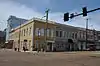 Spengler's Corner |
October 20, 1977 (#77000789) |
101 N. State St. 32°17′57″N 90°10′49″W |
Jackson | |
| 99 | Spengler's Corner Historic District | .jpg.webp) Spengler's Corner Historic District |
November 15, 1979 (#79001311) |
E. Capitol, N. State, and N. President Sts; also 400 blk. E. Capitol, 100-300 blks N. State & 100 blk. N. & S. President Sts. 32°17′57″N 90°10′50″W |
Jackson | Second set of addresses represent a boundary increase approved January 24, 2019 |
| 100 | Spengler-Thomas Building | .jpg.webp) Spengler-Thomas Building |
May 9, 2003 (#03000387) |
129 S. President 32°18′00″N 90°10′55″W |
Jackson | |
| 101 | Sub Rosa | .jpg.webp) Sub Rosa |
April 28, 1975 (#75001046) |
South of Pocahontas on U.S. Route 49 32°26′31″N 90°17′35″W |
Pocahontas | |
| 102 | Tanglewood | .jpg.webp) Tanglewood |
September 18, 2013 (#13000738) |
301 Jefferson St. 32°20′21″N 90°19′51″W |
Clinton | |
| 103 | Upper Midtown Historic District | October 3, 2014 (#100004503) |
Roughly bounded by Duncan Ave., N. West St., McTyere Ave. & North Mill St. 32°19′21″N 90°11′08″W |
Jackson | ||
| 104 | Virden-Patton House | 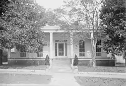 Virden-Patton House |
December 16, 1983 (#83003962) |
512 N. State St. 32°18′13″N 90°10′44″W |
Jackson | |
| 105 | Warren-Guild-Simmons House |  Warren-Guild-Simmons House |
January 11, 1979 (#79001312) |
734 Fairview St. 32°19′13″N 90°10′36″W |
Jackson | |
| 106 | Waterhouse-Simmons House | May 11, 2018 (#100002422) |
646 Seneca Ave. 32°20′28″N 90°10′23″W |
Jackson | ||
| 107 | Eudora Welty House | .jpg.webp) Eudora Welty House |
November 21, 2002 (#02001388) |
1119 Pinehurst St. 32°19′08″N 90°10′13″W |
Jackson | |
| 108 | West Capitol Street Historic District | .jpg.webp) West Capitol Street Historic District |
March 13, 1980 (#80002248) |
Roughly bounded by railroad tracks and Amite, Roach, and Pearl Sts. 32°18′02″N 90°11′24″W |
Jackson | |
| 109 | Wiener House at 228 Ridge Drive | .jpg.webp) Wiener House at 228 Ridge Drive |
November 2, 2009 (#09000884) |
228 Ridge Dr. 32°20′25″N 90°10′02″W |
Jackson | |
| 110 | Alex Williams House | 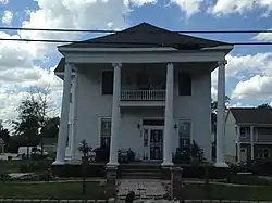 Alex Williams House |
July 3, 1979 (#79001313) |
937 N. Lamar St. 32°18′33″N 90°11′04″W |
Jackson | |
| 111 | Woodrow Wilson Bridge | .jpg.webp) Woodrow Wilson Bridge |
November 16, 1988 (#88002485) |
Spans the Pearl River on Silas Brown St. 32°17′22″N 90°10′44″W |
Jackson | Extends into Rankin County |
| 112 | Wolfe House | _(4).jpg.webp) Wolfe House |
June 22, 1989 (#89000762) |
401 Claiborne 32°05′48″N 90°17′56″W |
Terry |
Former listings
| [3] | Name on the Register | Image | Date listed | Date removed | Location | City or town | Summary |
|---|---|---|---|---|---|---|---|
| 1 | Armour Company Smokehouse and Distribution Plant | November 25, 1983 (#83003956) | November 12, 2009 | 320 W. Pearl St. 32°17′59″N 90°11′32″W |
Jackson | ||
| 2 | Cain Hall | March 10, 1997 (#97000214) | December 15, 1999 | Hinds Community College, approximately .75 mi. W of jct. of MS 18 and MS 467 |
Raymond | Destroyed by fire March 7, 1998[7] | |
| 3 | Will Watkins House | September 13, 1978 (#78001602) | May 15, 1987 | 1423 N. State St. |
Jackson | Destroyed by fire in 1984[8] | |
| 4 | Welty House | October 27, 1980 (#80002247) | March 6, 1986 | 741 N. Congress St. |
Jackson | Childhood home of Eudora Welty. Removed due to significant alteration[9] |
See also
| Wikimedia Commons has media related to National Register of Historic Places in Hinds County, Mississippi. |
References
- The latitude and longitude information provided in this table was derived originally from the National Register Information System, which has been found to be fairly accurate for about 99% of listings. Some locations in this table may have been corrected to current GPS standards.
- "National Register of Historic Places: Weekly List Actions". National Park Service, United States Department of the Interior. Retrieved on January 29, 2021.
- Numbers represent an alphabetical ordering by significant words. Various colorings, defined here, differentiate National Historic Landmarks and historic districts from other NRHP buildings, structures, sites or objects.
- "National Register Information System". National Register of Historic Places. National Park Service. March 13, 2009.
- The eight-digit number below each date is the number assigned to each location in the National Register Information System database, which can be viewed by clicking the number.
- Location derived from this National Park Service webpage; the NRIS lists the site as "Address Restricted"
- MDAH
- MDAH
- MDAH
| Topics | |
|---|---|
| Lists by state |
|
| Lists by insular areas | |
| Lists by associated state | |
| Other areas | |
| Related | |
| |
Municipalities and communities of Hinds County, Mississippi, United States | ||
|---|---|---|
| Cities | Map of Mississippi highlighting Hinds County | |
| Towns | ||
| Unincorporated communities | ||
| Footnotes | ‡ This populated place also has portions in an adjacent county or counties | |
| ||
This article is issued from Wikipedia. The text is licensed under Creative Commons - Attribution - Sharealike. Additional terms may apply for the media files.