National Register of Historic Places listings in Warren County, Mississippi
This is a list of the National Register of Historic Places listings in Warren County, Mississippi.
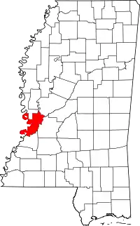
Location of Warren County in Mississippi
This is intended to be a complete list of the properties and districts on the National Register of Historic Places in Warren County, Mississippi, United States. Latitude and longitude coordinates are provided for many National Register properties and districts; these locations may be seen together in a map.[1]
There are 75 properties and districts listed on the National Register in the county, including 3 National Historic Landmarks. Another 2 properties were once listed but have been removed.
- This National Park Service list is complete through NPS recent listings posted February 5, 2021.[2]
Current listings
| [3] | Name on the Register[4] | Image | Date listed[5] | Location | City or town | Description |
|---|---|---|---|---|---|---|
| 1 | 1300 Grove Street House | November 29, 1983 (#83003976) |
1300 Grove St. 32°21′03″N 90°52′28″W |
Vicksburg | ||
| 2 | Anchuca | 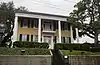 Anchuca |
March 22, 1982 (#82003113) |
1010 1st E. St. 32°21′16″N 90°52′38″W |
Vicksburg | |
| 3 | Anshe Chesed Cemetery | 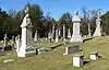 Anshe Chesed Cemetery |
September 10, 2014 (#14000569) |
Grove St. 32°20′43″N 90°51′14″W |
Vicksburg | |
| 4 | Balfour House | 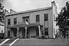 Balfour House |
October 26, 1971 (#71000458) |
1002 Crawford St. 32°20′51″N 90°52′43″W |
Vicksburg | |
| 5 | Beck House | .jpg.webp) Beck House |
March 29, 1979 (#79001336) |
1101 South St. 32°20′52″N 90°52′38″W |
Vicksburg | |
| 6 | Belle Fleur | .jpg.webp) Belle Fleur |
May 7, 1992 (#92000469) |
1123 South St. 32°20′52″N 90°53′17″W |
Vicksburg | |
| 7 | Bethel African Methodist Episcopal Church | 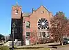 Bethel African Methodist Episcopal Church |
July 30, 1992 (#92000858) |
805 Monroe St. 32°21′16″N 90°52′43″W |
Vicksburg | |
| 8 | Beulah Cemetery | 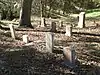 Beulah Cemetery |
October 23, 1992 (#92001404) |
Junction of Openwood St. and Old Jackson Rd. 32°21′26″N 90°50′59″W |
Vicksburg | |
| 9 | Biedenharn Candy Company Building | 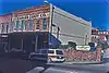 Biedenharn Candy Company Building |
December 2, 1977 (#77000793) |
1107-1109 Washington St. 32°21′05″N 90°52′53″W |
Vicksburg | |
| 10 | Big Black River Battlefield | .jpg.webp) Big Black River Battlefield |
November 23, 1971 (#71000451) |
On both banks of the Big Black River between Smith's Station and Bovina 32°21′36″N 90°43′35″W |
Bovina | Extends into Hinds County |
| 11 | Big Black River Railroad Bridge |  Big Black River Railroad Bridge |
November 16, 1988 (#88002418) |
Spans the Big Black River east of Bovina 32°20′49″N 90°42′17″W |
Bovina | Extends into Hinds County |
| 12 | Blum House | .jpg.webp) Blum House |
July 30, 1992 (#92000859) |
1420 Cherry St. 31°37′36″N 90°53′45″W |
Vicksburg | |
| 13 | Bobb House | 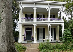 Bobb House |
January 8, 1979 (#79001337) |
1503 Harrison St. 32°20′45″N 90°52′21″W |
Vicksburg | |
| 14 | Isaac Bonham House | .jpg.webp) Isaac Bonham House |
May 26, 1977 (#77000794) |
601 Klein St. 32°20′29″N 90°53′06″W |
Vicksburg | |
| 15 | Carr Junior High School | Carr Junior High School |
April 5, 2002 (#00001055) |
1805 Cherry St. 32°20′41″N 90°52′43″W |
Vicksburg | |
| 16 | Cedar Grove |  Cedar Grove |
July 19, 1976 (#76001107) |
2200 Oak St. 32°20′25″N 90°53′08″W |
Vicksburg | |
| 17 | Chickasaw Bayou Battlefield | April 24, 1973 (#73001028) |
North of Vicksburg on U.S. Route 61 32°24′45″N 90°51′24″W |
Vicksburg | Site of the Battle of Chickasaw Bayou | |
| 18 | Christian and Brough Building | Christian and Brough Building |
June 2, 2014 (#14000278) |
923 Washington St. 32°21′12″N 90°52′53″W |
Vicksburg | |
| 19 | Church of the Holy Trinity |  Church of the Holy Trinity |
May 22, 1978 (#78001633) |
South and Monroe Sts. 32°20′50″N 90°52′47″W |
Vicksburg | |
| 20 | Confederate Avenue Brick Arch Bridge | Confederate Avenue Brick Arch Bridge |
November 16, 1988 (#88002421) |
Confederate Ave. 32°19′45″N 90°52′35″W |
Vicksburg | |
| 21 | Craig-Flowers House | .jpg.webp) Craig-Flowers House |
August 2, 1984 (#84002352) |
2011 Cherry St. 32°20′29″N 90°52′43″W |
Vicksburg | |
| 22 | Davis-Mitchell House | .jpg.webp) Davis-Mitchell House |
June 1, 1982 (#82003114) |
901 Crawford St. 32°20′57″N 90°52′46″W |
Vicksburg | |
| 23 | Fairground Street Bridge | .jpg.webp) Fairground Street Bridge |
November 16, 1988 (#88002420) |
Spans the Illinois Central railroad yard on Fairground St. 32°20′16″N 90°53′25″W |
Vicksburg | |
| 24 | Federal Fortifications Along Bear Creek | August 30, 1974 (#74001066) |
Southwest of Youngton 32°25′40″N 90°38′06″W |
Youngton | ||
| 25 | Feld House | August 2, 1982 (#82003115) |
2108 Cherry St. 32°20′26″N 90°52′46″W |
Vicksburg | ||
| 26 | Fitz-Hugh Hall | November 6, 1986 (#86003030) |
1322 Chambers St. 32°20′18″N 90°52′41″W |
Vicksburg | ||
| 27 | Col. Charles C. Flowerree House | 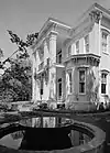 Col. Charles C. Flowerree House |
May 29, 1975 (#75001058) |
2309 Pearl St. 32°20′25″N 90°53′14″W |
Vicksburg | |
| 28 | Fonsylvania | September 7, 1984 (#84002355) |
Fisher Ferry Rd., south of Vicksburg 32°11′33″N 90°49′14″W |
Vicksburg | ||
| 29 | Fort St. Pierre Site |  Fort St. Pierre Site |
February 16, 2000 (#00000263) |
Off U.S. Route 61 north of Vicksburg[6] 32°29′44″N 90°47′55″W |
Vicksburg | |
| 30 | The Galleries | April 17, 1980 (#80002303) |
2421 Marshall St. 32°20′14″N 90°53′04″W |
Vicksburg | ||
| 31 | Glenwood-Vicklan Historic District | .jpg.webp) Glenwood-Vicklan Historic District |
November 3, 2009 (#09000886) |
Including Vicklan St., Glenwood Cir., Edna Dr., and Chambers St. east of the bayou 32°20′20″N 90°52′14″W |
Vicksburg | |
| 32 | Duff Green House | .jpg.webp) Duff Green House |
January 11, 1979 (#79001338) |
806 Locust St. 32°21′15″N 90°52′32″W |
Vicksburg | |
| 33 | Grove Street Houses | .jpg.webp) Grove Street Houses |
May 8, 1980 (#80002304) |
1117 and 1121 Grove St. 32°21′06″N 90°52′34″W |
Vicksburg | |
| 34 | Grove Street-Jackson Historic District | 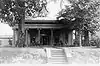 Grove Street-Jackson Historic District |
November 21, 2007 (#05001613) |
Along Grove and Jackson Sts. between Cherry St. and 1st N. St. 32°21′07″N 90°52′33″W |
Vicksburg | |
| 35 | Guider House | .jpg.webp) Guider House |
May 8, 1980 (#80002305) |
1115 Grove St. 32°21′05″N 90°52′35″W |
Vicksburg | |
| 36 | P.M. Harding House | .jpg.webp) P.M. Harding House |
July 17, 1986 (#86001674) |
1402 Chambers St. 32°20′18″N 90°52′35″W |
Vicksburg | |
| 37 | Hotel Vicksburg | .jpg.webp) Hotel Vicksburg |
June 4, 1979 (#79001339) |
801 Clay St. 32°21′00″N 90°52′50″W |
Vicksburg | |
| 38 | Joel and Margaret Hullum House | July 5, 1984 (#84002358) |
749 Mallet Rd. 32°12′47″N 90°52′27″W |
Vicksburg | ||
| 39 | Hyland Mound Archeological Site | August 30, 2001 (#01000920) |
Address Restricted |
Vicksburg | ||
| 40 | Jackson Street Missionary Baptist Church | .jpg.webp) Jackson Street Missionary Baptist Church |
January 11, 2017 (#100000538) |
1416 Jackson St. 32°21′07″N 90°52′20″W |
Vicksburg | |
| 41 | Fannie Willis Johnson House | 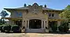 Fannie Willis Johnson House |
April 8, 1988 (#88000241) |
2430 Drummond St. 32°20′09″N 90°52′54″W |
Vicksburg | |
| 42 | Dr. Isaac Cecil Knox House | .jpg.webp) Dr. Isaac Cecil Knox House |
September 18, 1990 (#90001478) |
2823 Confederate Ave. 32°19′14″N 90°53′02″W |
Vicksburg | |
| 43 | John Lane House | 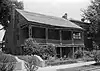 John Lane House |
May 6, 1982 (#82003116) |
905 Crawford St. 32°20′56″N 90°52′45″W |
Vicksburg | |
| 44 | W.W. Lassiter Wholesale Grocery Warehouse | March 7, 1994 (#94000149) |
1308 Levee St. 32°21′01″N 90°53′03″W |
Vicksburg | ||
| 45 | Loosa Yokena Archeological Site | May 8, 2001 (#01000481) |
Address Restricted |
Kimberly | ||
| 46 | Luckett Compound | 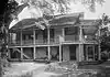 Luckett Compound |
July 28, 1983 (#83000968) |
1116-1122 Crawford St 32°20′53″N 90°52′36″W |
Vicksburg | |
| 47 | The Magnolias | _from_W_2.jpg.webp) The Magnolias |
February 26, 1987 (#87000217) |
1617 Monroe St. 32°20′45″N 90°52′49″W |
Vicksburg | |
| 48 | Magruder-Morrissey House | .jpg.webp) Magruder-Morrissey House |
May 24, 1984 (#84002361) |
1117 Cherry St. 32°21′03″N 90°52′41″W |
Vicksburg | |
| 49 | Main Street Historic District | .jpg.webp) Main Street Historic District |
April 16, 1979 (#79001340) |
1st East, Adams, Main, and Openwoods Sts.; also roughly bounded by Adams St., Main St., Cherry St., and 1st East St. 32°21′12″N 90°52′32″W |
Vicksburg | Second set of boundaries represents a boundary increase of January 5, 1989 |
| 50 | McDermott House | July 12, 1984 (#84002359) |
1100 South St. 32°20′50″N 90°52′40″W |
Vicksburg | ||
| 51 | McNutt House | 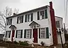 McNutt House |
May 29, 1975 (#75001059) |
Northwestern corner of Monroe and E. 1st Sts. 32°21′17″N 90°52′45″W |
Vicksburg | |
| 52 | Mississippi River Bridge | Mississippi River Bridge |
February 14, 1989 (#88002423) |
Spans the Mississippi River on Old U.S. Route 80 32°18′54″N 90°54′20″W |
Vicksburg | Extends into Madison Parish, Louisiana |
| 53 | Old Courthouse, Warren County | .jpg.webp) Old Courthouse, Warren County |
May 23, 1968 (#68000029) |
Court Sq. 32°21′07″N 90°52′43″W |
Vicksburg | |
| 54 | Pemberton's Headquarters | .jpg.webp) Pemberton's Headquarters |
July 23, 1970 (#70000319) |
1018 Crawford St. 32°20′54″N 90°52′40″W |
Vicksburg | |
| 55 | Planters Hall | .jpg.webp) Planters Hall |
June 21, 1971 (#71000459) |
822 Main St. 32°21′14″N 90°52′46″W |
Vicksburg | |
| 56 | Polk-Sherard-Hinman House | May 11, 2018 (#100002423) |
2615 Confederate Ave. 32°19′37″N 90°52′49″W |
Vicksburg | ||
| 57 | Rolling Acres Historic District | October 8, 2019 (#100004505) |
Elizabeth Circle and intersecting streets 32°21′16″N 90°51′10″W |
Vicksburg | ||
| 58 | Adolph Rose Building | .jpg.webp) Adolph Rose Building |
November 12, 1992 (#92001567) |
717 Clay St. 32°21′01″N 90°52′53″W |
Vicksburg | |
| 59 | St. Francis Xavier Convent | .jpg.webp) St. Francis Xavier Convent |
April 18, 1977 (#77000796) |
1021 Crawford St. 32°20′55″N 90°52′39″W |
Vicksburg | |
| 60 | Shlenker House | 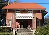 Shlenker House |
November 17, 1983 (#83003975) |
2212 Cherry St. 32°20′20″N 90°52′46″W |
Vicksburg | |
| 61 | Snyder's Bluff | February 6, 1973 (#73001027) |
Along the Yazoo River north of Redwood[7] 32°29′51″N 90°47′53″W |
Redwood | ||
| 62 | South Cherry Street Historic District | .jpg.webp) South Cherry Street Historic District |
November 14, 2003 (#03001140) |
Along Cherry and Drummond Sts. from Harrison St. to Bowmar St. and including Chambers and Baum Sts. 32°20′25″N 90°52′42″W |
Vicksburg | |
| 63 | South Drummond Street Neighborhood Historic District | September 28, 2015 (#15000667) |
Roughly bounded by Bowmar & Confederate Aves., Yerger, Green, 2nd, Oak Hill & Polk Sts., Halls Ferry Rd. 32°19′52″N 90°53′08″W |
Vicksburg | ||
| 64 | South Vicksburg Public School No. 200 | .jpg.webp) South Vicksburg Public School No. 200 |
March 20, 1986 (#86000482) |
900 Speed St. 32°20′18″N 90°53′06″W |
Vicksburg | |
| 65 | Tri-State Motor Coach Station | January 24, 2019 (#100003347) |
1511 Walnut St. 32°20′51″N 90°52′53″W |
Vicksburg | ||
| 66 | Uptown Vicksburg Historic District | 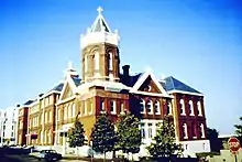 Uptown Vicksburg Historic District |
August 19, 1993 (#93000850) |
Roughly bounded by Locust, South, Washington, and Clay Sts.; also mostly on Washington St. between Grove and Veto Sts.; also roughly bounded by Washington, Grove, China, Clay, Locust, South & Veto Sts., 32°20′55″N 90°52′45″W |
Vicksburg | Second and third sets of boundaries represents boundary increases approved September 10, 2004 and February 4, 2020. |
| 67 | U.S.S. CAIRO | 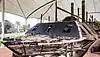 U.S.S. CAIRO |
September 3, 1971 (#71000068) |
U.S.S. Cairo Museum 32°22′33″N 90°52′00″W |
Vicksburg | |
| 68 | Vicksburg National Military Park | .jpg.webp) Vicksburg National Military Park |
October 15, 1966 (#66000100) |
North and east of Vicksburg 32°20′28″N 90°51′44″W |
Vicksburg | |
| 69 | Old Vicksburg Public Library | .jpg.webp) Old Vicksburg Public Library |
July 30, 1992 (#92000857) |
819 South St. 32°20′53″N 90°52′51″W |
Vicksburg | |
| 70 | Vicksburg Siege Cave | March 14, 1973 (#73001029) |
Near the Vicksburg City Cemetery 32°21′59″N 90°51′41″W |
Vicksburg | ||
| 71 | Walnut Hills | 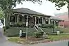 Walnut Hills |
March 19, 1982 (#82003117) |
1214 Adams St. 32°20′59″N 90°52′39″W |
Vicksburg | |
| 72 | Waterways Experiment Station | .png.webp) Waterways Experiment Station |
December 13, 2000 (#00001511) |
Roughly bounded by Spillway, Durden Creek, Tennessee Rd., and Dam Spillway 32°17′50″N 90°52′10″W |
Vicksburg | |
| 73 | Yazoo And Mississippi Valley Depot | .jpg.webp) Yazoo And Mississippi Valley Depot |
November 13, 1979 (#79001341) |
500 Grove St. 32°21′09″N 90°52′59″W |
Vicksburg | |
| 74 | Yokena Presbyterian Church |  Yokena Presbyterian Church |
September 7, 1984 (#84002442) |
South of Vicksburg on U.S. Route 61 32°10′25″N 90°56′31″W |
Vicksburg | |
| 75 | Young-Bradfield House | 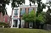 Young-Bradfield House |
May 6, 1982 (#82003118) |
913 Crawford St. 32°20′56″N 90°52′44″W |
Vicksburg |
Former listings
| [3] | Name on the Register | Image | Date listed | Date removed | Location | City or town | Summary |
|---|---|---|---|---|---|---|---|
| 1 | Confederate Avenue Steel Arch Bridge | 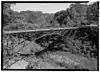 Confederate Avenue Steel Arch Bridge |
1988 (#88002483) | December 17, 2002 | Spans Jackson Rd. in Vicksburg National Military Park |
Vicksburg | Demolished by the National Park Service in June 2002[8] |
| 2 | Sprague | 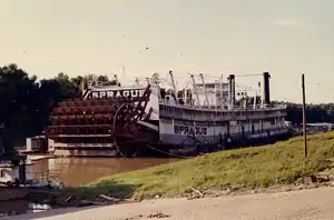 Sprague |
April 15, 1977 (#77000795) | May 15, 1987 | Vicksburg Harbor |
Vicksburg | Destroyed by fire[9] |
See also
| Wikimedia Commons has media related to National Register of Historic Places in Warren County, Mississippi. |
References
- The latitude and longitude information provided in this table was derived originally from the National Register Information System, which has been found to be fairly accurate for about 99% of listings. Some locations in this table may have been corrected to current GPS standards.
- "National Register of Historic Places: Weekly List Actions". National Park Service, United States Department of the Interior. Retrieved on February 5, 2021.
- Numbers represent an alphabetical ordering by significant words. Various colorings, defined here, differentiate National Historic Landmarks and historic districts from other NRHP buildings, structures, sites or objects.
- "National Register Information System". National Register of Historic Places. National Park Service. March 13, 2009.
- The eight-digit number below each date is the number assigned to each location in the National Register Information System database, which can be viewed by clicking the number.
- Location derived from NRIS provided coordinates; although the NRIS provides the coordinates, it lists the site as "Address Restricted"
- Location derived from its GNIS feature record; the NRIS lists the site as "Address Restricted"
- MDAH
- MDAH
| Topics | |
|---|---|
| Lists by state |
|
| Lists by insular areas | |
| Lists by associated state | |
| Other areas | |
| Related | |
| |
Municipalities and communities of Warren County, Mississippi, United States | ||
|---|---|---|
| City | Map of Mississippi highlighting Warren County | |
| CDP | ||
| Other unincorporated communities | ||
| Ghost town | ||
| ||
This article is issued from Wikipedia. The text is licensed under Creative Commons - Attribution - Sharealike. Additional terms may apply for the media files.