National Register of Historic Places listings in Jefferson County, Montana
This is a list of the National Register of Historic Places listings in Dawson County, Montana. It is intended to be a complete list of the properties and districts on the National Register of Historic Places in Dawson County, Montana, United States. The locations of National Register properties and districts for which the latitude and longitude coordinates are included below, may be seen in a map.[1]
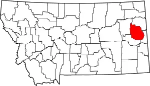
Location of Dawson County in Montana
There are 13 properties and districts listed on the National Register in the county, including 1 National Historic Landmark.
- This National Park Service list is complete through NPS recent listings posted January 29, 2021.[2]
Listings county-wide
| [3] | Name on the Register | Image | Date listed[4] | Location | City or town | Description |
|---|---|---|---|---|---|---|
| 1 | Boulder Hot Springs Hotel |  Boulder Hot Springs Hotel |
January 12, 1979 (#79001403) |
Southeast of Boulder on Montana Highway 281 46°12′02″N 112°05′33″W |
Boulder | |
| 2 | W.C. Child Ranch | _-_Jefferson_County%252C_Montana.png.webp) W.C. Child Ranch |
November 23, 1977 (#77000819) |
South of East Helena on Montana Highway 518 46°34′05″N 111°54′42″W |
East Helena | |
| 3 | Fraternity Hall | 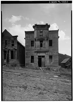 Fraternity Hall |
April 3, 1975 (#75001084) |
Main St. 46°16′30″N 111°56′44″W |
Elkhorn | |
| 4 | The Grant-Marshall Lime Kiln Historic District | December 14, 2017 (#100001898) |
1000 ft. S of S end of Crystal Dr. 46°34′06″N 111°59′47″W |
Helena | ||
| 5 | Homestake Airway Beacon | May 31, 2019 (#100004037) |
Along Continental Divide at Homestake Pass in Beaverhead-Deerlodge National Forest 45°55′11″N 112°25′00″W |
Butte vicinity | Extends into Silver Bow County. | |
| 6 | Jefferson Canyon Highway Historic District |  Jefferson Canyon Highway Historic District |
July 23, 2018 (#100002692) |
Milepost .5 to 12.3 of MT 2 45°50′24″N 111°54′34″W |
Cardwell vicinity | |
| 7 | Jefferson County Courthouse | 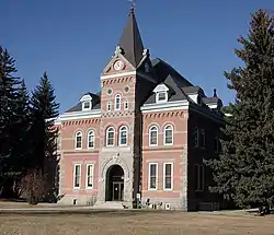 Jefferson County Courthouse |
August 6, 1980 (#80002422) |
200 Centennial Ave. 46°14′09″N 112°07′16″W |
Boulder | |
| 8 | Lewis and Clark Caverns Historic District | 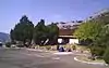 Lewis and Clark Caverns Historic District |
May 29, 2018 (#100002505) |
Lewis & Clark Caverns Rd 45°49′30″N 111°51′05″W |
LaHood vicinity | |
| 9 | MacHaffie Site (24JF4) | April 3, 1986 (#86000619) |
Address Restricted |
Montana City | ||
| 10 | Modern Hotel |  Modern Hotel |
December 22, 2011 (#11000951) |
Legion Ave. & Main St. 45°52′11″N 112°05′58″W |
Whitehall | |
| 11 | Montana Deaf and Dumb Asylum | _-_Jefferson_County%252C_Montana.png.webp) Montana Deaf and Dumb Asylum |
May 10, 1985 (#85000994) |
Off Montana Highway 281 46°13′52″N 112°08′24″W |
Boulder | |
| 12 | Montana State Training School Historic District | November 24, 2014 (#14000957) |
Roughly bounded by Montana Highway 69, Riverside Road, and the Boulder River 46°13′40″N 112°07′09″W |
Boulder | ||
| 13 | Whitetail Airway Beacon | March 13, 2020 (#100005094) |
16 miles north of Whitehall 46°04′48″N 112°08′25″W |
Whitehall vicinity |
See also
| Wikimedia Commons has media related to National Register of Historic Places in Jefferson County, Montana. |
References
- The latitude and longitude information provided in this table was derived originally from the National Register Information System, which has been found to be fairly accurate for about 99% of listings. Some locations in this table may have been corrected to current GPS standards.
- "National Register of Historic Places: Weekly List Actions". National Park Service, United States Department of the Interior. Retrieved on January 29, 2021.
- Numbers represent an alphabetical ordering by significant words. Various colorings, defined here, differentiate National Historic Landmarks and historic districts from other NRHP buildings, structures, sites or objects.
- The eight-digit number below each date is the number assigned to each location in the National Register Information System database, which can be viewed by clicking the number.
| Topics | |
|---|---|
| Lists by state |
|
| Lists by insular areas | |
| Lists by associated state | |
| Other areas | |
| Related | |
| |
Municipalities and communities of Jefferson County, Montana, United States | ||
|---|---|---|
| Towns | 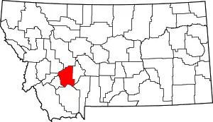 Jefferson County map | |
| CDPs | ||
| Unincorporated communities | ||
| ||
This article is issued from Wikipedia. The text is licensed under Creative Commons - Attribution - Sharealike. Additional terms may apply for the media files.