National Register of Historic Places listings in Knox County, Illinois
This is a list of the National Register of Historic Places listings in Knox County, Illinois.
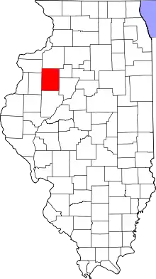
Location of Knox County in Illinois
This is intended to be a complete list of the properties and districts on the National Register of Historic Places in Knox County, Illinois, United States. Latitude and longitude coordinates are provided for many National Register properties and districts; these locations may be seen together in a map.[1]
There are 7 properties and districts listed on the National Register in the county. Another property was once listed but has been removed.
- This National Park Service list is complete through NPS recent listings posted January 29, 2021.[2]
Current listings
| [3] | Name on the Register | Image | Date listed[4] | Location | City or town | Description |
|---|---|---|---|---|---|---|
| 1 | J. Newton Conger House |  J. Newton Conger House |
April 20, 1979 (#79003111) |
334 N. Knox St. 41°04′33″N 90°13′41″W |
Oneida | |
| 2 | Galesburg Historic District | _1981.jpg.webp) Galesburg Historic District |
November 21, 1976 (#76000715) |
Roughly bounded by Berrien, Clark, Pearl, and Sanborn Sts. 40°57′07″N 90°22′09″W |
Galesburg | |
| 3 | Knox County Courthouse and Hall of Records | 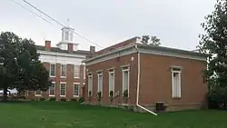 Knox County Courthouse and Hall of Records |
February 13, 1992 (#92000051) |
Public Sq., Main St. 40°54′30″N 90°17′04″W |
Knoxville | |
| 4 | Knox County Jail | 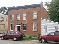 Knox County Jail |
February 13, 1992 (#92000050) |
Public Sq., Market St. 40°54′31″N 90°17′07″W |
Knoxville | |
| 5 | Meetinghouse of the Central Congregational Church | 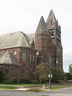 Meetinghouse of the Central Congregational Church |
September 30, 1976 (#76000716) |
Central Sq. 40°56′48″N 90°22′18″W |
Galesburg | |
| 6 | Old Main, Knox College | 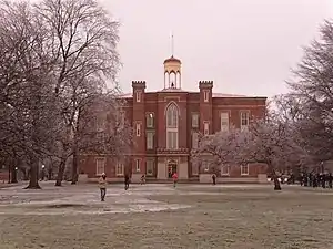 Old Main, Knox College |
October 15, 1966 (#66000323) |
Knox College campus 40°56′36″N 90°22′14″W |
Galesburg | Charles Ulricson, architect. Site of the October 7, 1858 Lincoln–Douglas debate. |
| 7 | Walnut Grove Farm | 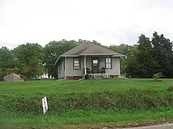 Walnut Grove Farm |
August 24, 1989 (#89001114) |
Knox Station Rd., 1 mile (1.6 km) north of Knoxville 40°55′11″N 90°16′07″W |
Knoxville |
Former listing
| [3] | Name on the Register | Image | Date listed | Date removed | Location | City or town | Summary |
|---|---|---|---|---|---|---|---|
| 1 | Wolf Covered Bridge | December 4, 1974 (#74000763) | December 8, 1995 | NW of Yates City on CR 17 over Spoon River |
Yates City | Destroyed by fire in 1994. |
See also
| Wikimedia Commons has media related to National Register of Historic Places in Knox County, Illinois. |
References
- The latitude and longitude information provided in this table was derived originally from the National Register Information System, which has been found to be fairly accurate for about 99% of listings. Some locations in this table may have been corrected to current GPS standards.
- "National Register of Historic Places: Weekly List Actions". National Park Service, United States Department of the Interior. Retrieved on January 29, 2021.
- Numbers represent an alphabetical ordering by significant words. Various colorings, defined here, differentiate National Historic Landmarks and historic districts from other NRHP buildings, structures, sites or objects.
- The eight-digit number below each date is the number assigned to each location in the National Register Information System database, which can be viewed by clicking the number.
| Topics | |
|---|---|
| Lists by state |
|
| Lists by insular areas | |
| Lists by associated state | |
| Other areas | |
| Related | |
| |
Municipalities and communities of Knox County, Illinois, United States | ||
|---|---|---|
| Cities | Map of Illinois highlighting Knox County | |
| Villages | ||
| Townships | ||
| CDPs | ||
| Other unincorporated communities | ||
| Ghost towns | ||
| Footnotes | ‡This populated place also has portions in an adjacent county or counties | |
| ||
This article is issued from Wikipedia. The text is licensed under Creative Commons - Attribution - Sharealike. Additional terms may apply for the media files.