National Register of Historic Places listings in Lafayette County, Wisconsin
This is a list of the National Register of Historic Places listings in Lafayette County, Wisconsin. It is intended to provide a comprehensive listing of entries in the National Register of Historic Places that are located in Lafayette County, Wisconsin. The locations of National Register properties for which the latitude and longitude coordinates are included below may be seen in a map.[1]
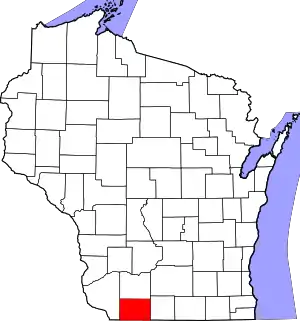
Location of Lafayette County in Wisconsin
There are 11 properties and districts listed on the National Register in the county.
- This National Park Service list is complete through NPS recent listings posted February 5, 2021.[2]
Current listings
| [3] | Name on the Register[4] | Image | Date listed[5] | Location | City or town | Description |
|---|---|---|---|---|---|---|
| 1 | Benton Stone Water Tower | 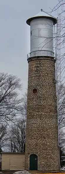 Benton Stone Water Tower |
January 7, 1999 (#98001598) |
49 Water St. 42°34′15″N 90°22′58″W |
Benton | 67-foot limestone water tower, now topped with a steel tank. Built after an 1899 fire convinced the community that it needed a "waterworks" system. |
| 2 | First Capitol | 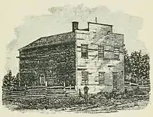 First Capitol |
April 28, 1970 (#70000036) |
North of Belmont off U.S. 151 42°46′07″N 90°21′45″W |
Belmont | The first capitol of Wisconsin Territory, built by John Atchison in 1836 to promote his proposed town. The territorial legislature met there for one session, then moved to warmer and less-remote quarters. |
| 3 | Gratiot House | 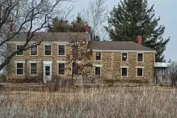 Gratiot House |
January 8, 1980 (#80000153) |
South of Shullsburg on Rennick Rd. 42°33′09″N 90°13′52″W |
Shullsburg | Georgian-styled limestone house built by Henry Gratiot in 1835. Last remaining building of Gratiot Grove, one of the state's first settlements, a lead-mining outpost begun in Winnebago territory in 1826 on the stage road from Galena to Chicago.[6][7] |
| 4 | Lafayette County Courthouse | 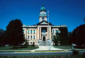 Lafayette County Courthouse |
December 22, 1978 (#78000114) |
626 Main St. 42°40′57″N 90°07′06″W |
Darlington | Neoclassical courthouse built in 1905, funded by Matt Murhpy of Benton. |
| 5 | Main Street Historic District | .JPG.webp) Main Street Historic District |
October 7, 1994 (#94001210) |
Roughly bounded by Main, Ann, Louisa and Wells Sts. 42°40′46″N 90°07′04″W |
Darlington | Darlington's old downtown, including the 1860 J.B. Cutting Livery Stable,[8] the 1879 Italianate-styled Schreiter Building,[9] the 1883 Romanesque Revival Driver's Store and Opera House,[10] the 1896 Queen Anne Miller and Fardy Dry Goods Store,[11] the 1911 Neoclassical Odd Fellows Hall,[12] the 1919 Commercial Vernacular Hotel Olson,[13] and the 1930 Moderne-style Iowa Oil Co. & Filling Station.[14][15] |
| 6 | Mottley Family Farmstead | 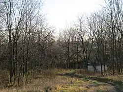 Mottley Family Farmstead |
May 25, 2001 (#01000564) |
21496 Ivey Rd. 42°48′14″N 90°08′45″W |
Willow Springs | Abandoned farm on an isolated ravine, begun in 1854 by English immigrants Abraham and Susan Motley. Remaining are 1.5 story limestone farmhouse probably begun around 1860, bank barn, and other structures. The Motleys raised milk cows, pigs, wheat, corn and potatoes. The farm stayed in their family until 1972.[16][17][18] |
| 7 | Pecatonica Battlefield | 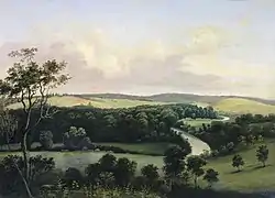 Pecatonica Battlefield |
July 28, 2011 (#11000488) |
2995 County Road Y 42°39′41″N 89°52′36″W |
Wiota | Site where Colonel Dodge's militia defeated a party of Kickapoo warriors, a turning point in the Black Hawk War. |
| 8 | Prairie Spring Hotel | 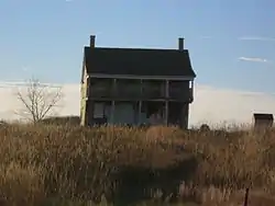 Prairie Spring Hotel |
October 21, 1999 (#99001273) |
WI 23 South 42°48′02″N 90°07′56″W |
Willow Springs | Fine 2-story I-house built in 1833 as a hotel on the military road from Mineral Point to Galena, when most other buildings in the lead-mining area were much simpler. |
| 9 | St. Augustine Church |  St. Augustine Church |
February 23, 1972 (#72000057) |
Off County Road W 42°31′59″N 90°20′01″W |
New Diggings | Early Catholic church built in 1844 during lead-mining days, designed by pioneer priest Father Mazzuchelli. |
| 10 | Star Theatre | 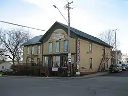 Star Theatre |
November 7, 1980 (#80000154) |
200 S. North St. 42°41′59″N 89°52′02″W |
Argyle | Woodworking shop downstairs and community hall upstairs, built by carpenter Alanson Partridge in 1878 and 1881. Used as a movie theater from 1920 into the 40s. |
| 11 | Water Street Commercial Historic District | 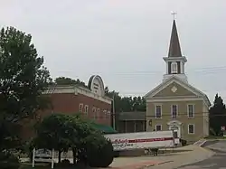 Water Street Commercial Historic District |
June 28, 1990 (#90000998) |
Roughly Water St. from Judgement to Kennedy Sts. and Gratiot St. from Water to Church Sts. 42°34′32″N 90°14′20″W |
Shullsburg | Shullsburg's downtown, both now and during early lead-mining. Properties include the 1847/78/84 City Hotel,[19] the 1855/1886 Brewster House Hotel,[20] the 1867 Greek Revival Methodist Episcopal Church,[21] 1882 Copeland Opera House,[22] the 1884 Italianate Merchants Union Bank,[23] the 1884 Gothic Revival/eclectic Williams Estate Building,[24] the 1903 Gerlach Saloon,[25] and the 1920 20th Century Commercial-styled Gem Garage.[26][27] |
See also
References
- The latitude and longitude information provided is primarily from the National Register Information System, and has been found to be fairly accurate for about 99% of listings. For 1%, the location info may be way off. We seek to correct the coordinate information wherever it is found to be erroneous. Please leave a note in the Discussion page for this article if you believe any specific location is incorrect.
- "National Register of Historic Places: Weekly List Actions". National Park Service, United States Department of the Interior. Retrieved on February 5, 2021.
- Numbers represent an alphabetical ordering by significant words. Various colorings, defined here, differentiate National Historic Landmarks and historic districts from other NRHP buildings, structures, sites or objects.
- "National Register Information System". National Register of Historic Places. National Park Service. April 24, 2008.
- The eight-digit number below each date is the number assigned to each location in the National Register Information System database, which can be viewed by clicking the number.
- "Gratiot House (Henry Gratiot)". Wisconsin Historical Society. Retrieved 2017-04-09.
- Andrea J. Lazarski; David Donath; J.W. Hatfield (October 1978). "NRHP Inventory/Nomination: Gratiot House". National Park Service. Retrieved 2017-04-09. With two photos.
- "J.B. Cutting Livery Stable". Wisconsin Historical Society. Retrieved 2017-04-09.
- "David Schreiter Store". Wisconsin Historical Society. Retrieved 2017-04-09.
- "Driver's Store and Opera House". Wisconsin Historical Society. Retrieved 2017-04-09.
- "Miller and Fardy Dry Goods". Wisconsin Historical Society. Retrieved 2017-04-09.
- "Odd Fellows Hall". Wisconsin Historical Society. Retrieved 2017-04-09.
- "Hotel Olson". Wisconsin Historical Society. Retrieved 2017-04-09.
- "Iowa Oil Co.& Filling Station". Wisconsin Historical Society. Retrieved 2017-04-09.
- Elizabeth L. Miller (1994-03-24). "NRHP Inventory/Nomination: Main Street Historic District". National Park Service. Retrieved 2017-04-09. With 20 photos.
- "Mottley Family Farmstead - House". Wisconsin Historical Society. Retrieved 2017-04-09.
- "Mottley Family Farmstead - barn". Wisconsin Historical Society. Retrieved 2017-04-09.
- Jane Eiseley (2000-10-20). "NRHP Inventory/Nomination: Mottley Family Farmstead". National Park Service. Retrieved 2017-04-09. With ten photos.
- "City Hotel". Wisconsin Historical Society. Retrieved 2017-05-08.
- "Brewster House Hotel". Wisconsin Historical Society. Retrieved 2017-05-08.
- "Centenary Methodist-Primitive Methodist Church". Wisconsin Historical Society. Retrieved 2017-05-08.
- "Copeland Opera House". Wisconsin Historical Society. Retrieved 2017-05-08.
- "Merchants Union Bank". Wisconsin Historical Society. Retrieved 2017-05-08.
- "Williams Estate Building". Wisconsin Historical Society. Retrieved 2017-05-08.
- "Frank Gerlach Saloon". Wisconsin Historical Society. Retrieved 2017-05-08.
- "Gem Garage". Wisconsin Historical Society. Retrieved 2017-05-08.
- Terry L. Shoptaugh; Diane H. Filipowicz (1980-06-08). "NRHP Registration: Water Street Commercial Historic District". National Park Service. With 33 photos.
| Wikimedia Commons has media related to National Register of Historic Places in Lafayette County, Wisconsin. |
This article is issued from Wikipedia. The text is licensed under Creative Commons - Attribution - Sharealike. Additional terms may apply for the media files.