National Register of Historic Places listings in Madison County, Montana
This is a list of the National Register of Historic Places listings in Madison County, Montana. It is intended to be a complete list of the properties and districts on the National Register of Historic Places in Madison County, Montana, United States. The locations of National Register properties and districts for which the latitude and longitude coordinates are included below, may be seen in a map.[1]
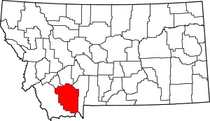
Location of Madison County in Montana
There are 18 properties and districts listed on the National Register in the county, including 1 National Historic Landmark.
- This National Park Service list is complete through NPS recent listings posted January 29, 2021.[2]
Listings county-wide
| [3] | Name on the Register | Image | Date listed[4] | Location | City or town | Description |
|---|---|---|---|---|---|---|
| 1 | Beaverhead Rock-Lewis and Clark Expedition | 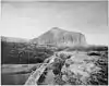 Beaverhead Rock-Lewis and Clark Expedition |
February 11, 1970 (#70000359) |
About 14 miles northeast of Dillon 45°23′18″N 112°27′29″W |
Dillon | |
| 2 | Dr. Don L. Byam House | 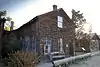 Dr. Don L. Byam House |
March 1, 2002 (#02000103) |
Main St. 45°18′27″N 111°58′04″W |
Nevada City | |
| 3 | Christ Episcopal Church and Rectory | 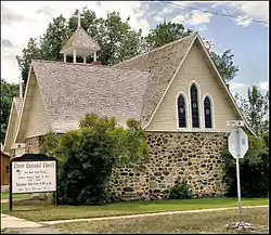 Christ Episcopal Church and Rectory |
January 22, 1987 (#86003672) |
304 S. Main St. 45°27′13″N 112°11′45″W |
Sheridan | |
| 4 | Doncaster Round Barn | 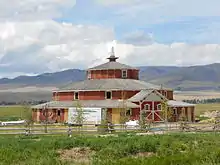 Doncaster Round Barn |
April 14, 2015 (#15000150) |
Riverside Dr. 45°34′12″N 112°18′49″W |
Twin Bridges vicinity | |
| 5 | Ferris-Hermsmeyer-Fenton Ranch | 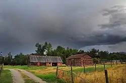 Ferris-Hermsmeyer-Fenton Ranch |
January 9, 2008 (#07001364) |
144 Duncan District Rd. 45°26′59″N 112°14′03″W |
Sheridan | Ranch established by Jane Ferris, a widow, in 1872. |
| 6 | Finney House | 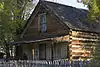 Finney House |
March 1, 2002 (#02000104) |
Junction of Main and California Sts. 45°18′28″N 111°58′05″W |
Nevada City | |
| 7 | Hutchins Bridge | March 18, 1999 (#99000344) |
across the Madison River 44°53′19″N 111°34′50″W |
Cameron vicinity | Triple-span Pratt through truss bridge built in 1902. | |
| 8 | Madison County Fairgrounds | August 3, 1984 (#84002500) |
Montana Highway 41 45°32′31″N 112°20′08″W |
Twin Bridges | ||
| 9 | William O'Brien House | October 23, 1986 (#86002933) |
114 E. Poppleton 45°27′16″N 112°11′40″W |
Sheridan | ||
| 10 | Pony Historic District | 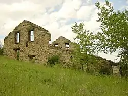 Pony Historic District |
August 4, 1987 (#87001264) |
Community of Pony, southwest of Harrison 45°39′25″N 111°53′50″W |
Pony | |
| 11 | Powder House | 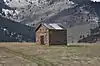 Powder House |
August 3, 1987 (#87001266) |
½ mile southeast of Pony on Potosi Rd. 45°39′22″N 111°52′33″W |
Pony | |
| 12 | Robbers Roost | January 1, 1976 (#76001124) |
5 miles north of Alder at Montana Highway 387A 45°23′33″N 112°08′49″W |
Alder | ||
| 13 | H.D. Rossiter Building | 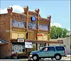 H.D. Rossiter Building |
March 7, 1994 (#94000138) |
115 S. Main St. 45°27′21″N 112°11′46″W |
Sheridan | |
| 14 | Saint Mary of the Assumption | .jpg.webp) Saint Mary of the Assumption |
October 24, 1985 (#85003380) |
Off Montana Highway 287 45°21′15″N 112°06′26″W |
Laurin | |
| 15 | Strawberry Mine Historic District | August 4, 1987 (#87001265) |
Roughly bounded by Strawberry Ridge, Pony Rd., and Pony Creek 45°39′50″N 111°56′14″W |
Pony | ||
| 16 | Thexton Ranch | May 12, 2006 (#06000426) |
335 Varney Rd. 45°16′53″N 111°45′44″W |
Ennis | ||
| 17 | Union City | 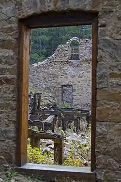 Union City |
February 26, 1999 (#99000261) |
Southeast of Virginia City[5] 45°12′30″N 111°56′03″W |
Virginia City | An abandoned mining camp[6] |
| 18 | Virginia City Historic District | 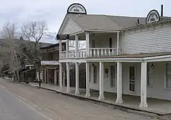 Virginia City Historic District |
October 15, 1966 (#66000435) |
Wallace St. 45°17′27″N 111°56′35″W |
Virginia City |
See also
| Wikimedia Commons has media related to National Register of Historic Places in Madison County, Montana. |
References
- The latitude and longitude information provided in this table was derived originally from the National Register Information System, which has been found to be fairly accurate for about 99% of listings. Some locations in this table may have been corrected to current GPS standards.
- "National Register of Historic Places: Weekly List Actions". National Park Service, United States Department of the Interior. Retrieved on January 29, 2021.
- Numbers represent an alphabetical ordering by significant words. Various colorings, defined here, differentiate National Historic Landmarks and historic districts from other NRHP buildings, structures, sites or objects.
- The eight-digit number below each date is the number assigned to each location in the National Register Information System database, which can be viewed by clicking the number.
- Location derived from its GNIS feature record; the NRIS lists it as "Address Restricted."
- U.S. Geological Survey Geographic Names Information System: Union City (historical)
| Topics | |
|---|---|
| Lists by state |
|
| Lists by insular areas | |
| Lists by associated state | |
| Other areas | |
| Related | |
| |
Municipalities and communities of Madison County, Montana, United States | ||
|---|---|---|
| Towns | Madison County map | |
| CDPs | ||
| Ghost towns |
| |
| Unincorporated communities | ||
| Footnotes | ‡This populated place also has portions in an adjacent county or counties | |
| ||
This article is issued from Wikipedia. The text is licensed under Creative Commons - Attribution - Sharealike. Additional terms may apply for the media files.