Madison River
The Madison River is a headwater tributary of the Missouri River, approximately 183 miles (295 km) long, in Wyoming and Montana. Its confluence with the Jefferson and Gallatin rivers near Three Forks, Montana forms the Missouri River.
| Madison River | |
|---|---|
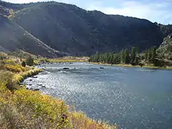 Lower Madison River In Bear Trap Canyon Below Ennis, Montana | |
 Montana rivers. The Madison is in the southwest corner. | |
| Location | |
| Country | United States |
| State | Wyoming, Montana |
| Physical characteristics | |
| Source | Madison Junction |
| • location | Yellowstone National Park, Wyoming |
| • coordinates | 44°38′32″N 110°51′56″W[1] |
| Mouth | Missouri River |
• location | Three Forks, Montana |
• coordinates | 45°55′39″N 111°30′29″W[1] |
| Length | 183 mi (295 km) |
| Discharge | |
| • location | near Three Forks |
| • average | 1,647 cu ft/s (46.6 m3/s)[2] |
| Basin features | |
| Tributaries | |
| • left | Firehole River |
| • right | Gibbon River |
The Madison rises in Teton County in northwestern Wyoming at the confluence of the Firehole and Gibbon rivers, a location known as Madison Junction in Yellowstone National Park. It flows west then north through the mountains of southwestern Montana to join the Jefferson and Gallatin rivers at Three Forks. The Missouri River Headwaters State Park is located on the Madison at Three Forks.[3] In its upper reaches in Gallatin County, Montana, the Hebgen Dam forms Hebgen Lake. In its middle reaches in Madison County, Montana, the Madison Dam forms Ennis Lake and provides hydroelectric power. In 1959, the 1959 Hebgen Lake earthquake formed Quake Lake just downstream from Hebgen Dam. Downstream from Ennis, the Madison flows through Bear Trap Canyon, known for its class IV-V whitewater.[4] The Bear Trap Canyon section is part of the Lee Metcalf Wilderness area.
The river was named in July 1805 by Meriwether Lewis at Three Forks. The central fork of the three, it was named for U.S. Secretary of State James Madison, who would succeed Thomas Jefferson as President in 1809. The western fork, the largest, was named for President Jefferson and the east fork for Treasury Secretary Albert Gallatin.
The Madison is a Class I river in Montana for the purposes of access for recreational use.[5]
Angling the Madison
The Madison River, from Madison Junction in Yellowstone to Three Forks, is a fly fishing mecca for serious anglers. It is classified as a blue ribbon fishery in Montana and is one of the most productive streams in Montana for brown trout, rainbow trout and mountain whitefish.[6]
For angling purposes, the Madison can be divided into four distinct sections.
| Madison River in Yellowstone National Park | |
|---|---|
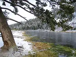 Madison River near Seven Mile (11 km) bridge |
The 19 miles (31 km) of the Madison in the park, although easily accessible, is not suited for beginners and offers technical dry fly and nymph fishing for rainbow and brown trout averaging from ten to fourteen inches (356 mm), with an occasional 20-incher. Most of the river inside the park resembles a large spring creek and has been called the world's largest chalkstream.
The Madison is an early summer and fall river and offers poor fishing in midsummer because of high temperatures contributed by the Firehole. Fishing in the fall is excellent when significant numbers of brown and rainbow trout enter the river from Hebgen Lake. These are usually taken with large streamer patterns. Many pools and runs on the Madison have angler-given names reminiscent of eastern trout stream and British salmon rivers—The Barns, Beaver Meadows, Grasshopper Bank, Cable Car Run and Baker's Hole,.[7][8] The Madison River is fly fishing only in Yellowstone National Park and all fishing is catch and release.[9] |
| Yellowstone National Park Boundary to Quake Lake | |
| After the Madison River takes its leave from Yellowstone Park, it meanders out into the beautiful ranch lands of southwestern Montana. It is here that its true character is revealed and its reputation as a world-class fishery is secured. The Madison rolls majestically through cottonwood lined banks and over riffles and quiet runs that harbor large rainbows and trophy browns. The Madison River flows along Yellowstone's West Entrance road into Hebgen Lake outside the park. In 1959, the Hebgen Lake earthquake formed Quake Lake just downstream from Hebgen Dam.[10] | |
| Upper Madison- Quake Lake to Ennis Lake | |
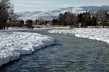 Madison River at Ennis in January |
Directly below Quake Lake a three-mile (5 km) long whitewater section resulted from the 1959 earthquake. It is characterized by a steep gradient of river including large boulders with Class V whitewater.
Below the whitewater section the river turns into a swift flowing but gentle river for 53 miles (85 km) to Ennis lake. This section has often been called the Fifty Mile Riffle and provides the best fly fishing on the river. Several remote fly shops exist along the middle and upper sections of the Upper Madison River, however the only significant town along the river is Ennis, near Ennis Lake. Due to the Upper Madison River's abundance of quality rainbow and brown trout, Ennis has been appropriately dubbed Trout Town, USA by many local and traveling fly fishermen.[11] There are two parts of the upper Madison River that are only open to wade fishing. Boats are allowed to float through these sections but anglers are not allowed to fish from the boat. The first section extends from Three Dollar Bridge to Lyons Bridge. The second wade-only section is from the Ennis town bridge downstream to Ennis Lake.[12] |
| Lower Madison- Ennis Lake to Three Forks | |
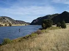 Lower Madison River Near Black's Ford access, September |
This section of the Madison begins with a short section of river between Ennis Dam and the power station, which normally contains a fraction of the river's water and offers excellent wading opportunities. After the powerhouse the river regains its full size and enters the Bear Trap Canyon for 7 miles. Access is limited to the bottom of the canyon by way of hiking trails on either side. The trails extend into the canyon for as far as anglers are willing hike, and since the Bear Trap Canyon is a designated wilderness area, it offers solitude for those willing to seek it. Floating through the canyon is possible, but is not done often due to a lengthy shuttle and class III-IV whitewater in the first half of the canyon.
After the river leaves the canyon it flows in shallow riffles until it eventually reaches Three Forks and contributes to the Missouri River headwaters. This section, which begins at Warm Spring FAS, offers easy floating and terrific wade access until Greycliff FAS. After that access is more limited and floats are much longer. The Lower Madison fishes well for three of the four seasons, with summer weather often warming the water to levels that are dangerous for catch and release fishing. The winter season, particularly in the Bear Trap Canyon, is a favorite among locals and is noted for good midge hatches on the days when the wind is calm.[13] |
Advocates
- Trout Unlimited — Trout Unlimited's mission is to conserve, protect and restore North America's coldwater fisheries and their watersheds.[14]
- Western Watersheds Project — The mission of Western Watersheds Project is to protect and restore western watersheds and wildlife through education, public policy initiatives and litigation.[15]
- Montana River Action — The clean flowing waters of Montana belong to the people and are held in trust by the State for a pollution-free healthful environment guaranteed by our Montana Constitution. Montana River Action's mission is to protect and restore rivers, streams and other water bodies.[16]
- Madison River Foundation--- The mission of the Madison River Foundation is to preserve, protect, and enhance the Madison River watershed.[17]
See also
Notes
- U.S. Geological Survey Geographic Names Information System: Madison River, USGS GNIS
- https://waterdata.usgs.gov/mt/nwis/annual/?format=sites_selection_links&search_site_no=06042500&agency_cd=USGS&referred_module=sw
- Montana Fish and Wildlife and Parks Archived 2007-05-21 at the Wayback Machine
- Fischer, Hank; Fischer, Carol (2008). Paddling Montana. Guildford, CT: The Globe Pequot Press. pp. 111–113. ISBN 978-0-7627-4352-0.
- Stream Access in Montana Archived 2009-03-10 at the Wayback Machine
- Montana Fish and Wildlife-Madison River Data
- Mathews, Craig; Molinero, Clayton (1997). The Yellowstone Fly-Fishing Guide-A authoritative guide to the waters of Yellowstone National Park. Guilford, CT: The Lyons Press. pp. 37–40. ISBN 1-55821-545-X.
- Parks, Richard (1998). Fishing Yellowstone National Park. Helena, MT: Falcon Press. pp. 30–34. ISBN 1-56044-625-0.
- 2009 Yellowstone National Park Fishing Regulations
- – Greater Yellowstone Resource Guide
- "Montana Trout Stalkers". www.montanatrout.com. Retrieved 2016-01-07.
- Holt, John (1993). River Journal – Madison. Portland, OR: Frank Amato Publications. p. 27. ISBN 1-878175-27-0.
- Robbins, Chuck (2008). Flyfisher's Guide to Montana. Belgrade, MT: Wilderness Adventures Press. p. 212-213. ISBN 1-932098-22-4
- Trout Unlimited website
- Western Watersheds Project website
- "Montana River Action Website". Archived from the original on 2009-03-05. Retrieved 2008-12-11.
- Madison River Foundation website
References
- Back, Howard (1938). The Waters of the Yellowstone with Rod and Fly. New York: Dodd & Mead.
- Parks, Richard (1998). Fishing Yellowstone National Park. Helena, MT: Falcon Press. ISBN 1-56044-625-0.
- Brooks, Charles E. (1979). The Living River-A Fisherman's Intimate Profile of the Madison River Watershed--Its History, Ecology, Lore and Angling Opportunities. Garden City, NJ: Nick Lyons Books. ISBN 0-385-15655-3.
- Mathews, Craig; Molinero, Clayton (1997). The Yellowstone Fly-Fishing Guide-A authoritative guide to the waters of Yellowstone National Park. Guilford, CT: The Lyons Press. ISBN 1-55821-545-X.
- Brooks, Charles E. (1984). Fishing Yellowstone Waters. Clinton, NJ: New Win Publishing Inc. ISBN 0-8329-0353-1.
- Holt, John (1996). Montana Fly-Fishing Guide-East. Guilford, CT: The Lyons Press. ISBN 1-58574-529-4.
- Holt, John (1993). River Journal - Madison. Portland, OR: Frank Amato Publications. ISBN 1-878175-27-0.
External links
| Wikimedia Commons has media related to Madison River. |
- . Collier's New Encyclopedia. 1921.

