National Register of Historic Places listings in Madison County, Nebraska
This is a list of the National Register of Historic Places listings in Madison County, Nebraska.
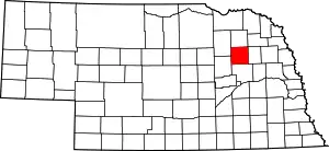
Location of Madison County in Nebraska
This is intended to be a complete list of the properties and districts on the National Register of Historic Places in Madison County, Nebraska, United States. The locations of National Register properties and districts for which the latitude and longitude coordinates are included below, may be seen in a map.[1]
There are 11 properties and districts listed on the National Register in the county.
- This National Park Service list is complete through NPS recent listings posted January 29, 2021.[2]
Current listings
| [3] | Name on the Register[4] | Image | Date listed[5] | Location | City or town | Description |
|---|---|---|---|---|---|---|
| 1 | Dommer-Haase Farmstead | 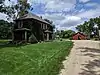 Dommer-Haase Farmstead |
November 5, 2018 (#100003094) |
2400 W Eisenhower Ave. 42°03′42″N 97°26′37″W |
Norfolk | |
| 2 | First United Presbyterian Church | 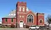 First United Presbyterian Church |
December 3, 2008 (#08001134) |
104 E. 4th St. 41°49′38″N 97°27′15″W |
Madison | |
| 3 | Grand Theater | _from_NE_2.JPG.webp) Grand Theater |
September 4, 2013 (#13000677) |
120 S. 3rd St. 42°01′55″N 97°24′37″W |
Norfolk | |
| 4 | Hotel Norfolk | _3.jpg.webp) Hotel Norfolk |
December 1, 1988 (#88002755) |
108 N. 4th St. 42°01′59″N 97°24′40″W |
Norfolk | |
| 5 | Karl Stefan Memorial Airport Administration Building | Karl Stefan Memorial Airport Administration Building |
July 11, 2002 (#02000767) |
4100 S. 13th St. 41°59′05″N 97°25′47″W |
Norfolk | |
| 6 | Mathewson-Gerecke House | 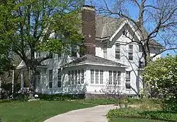 Mathewson-Gerecke House |
March 12, 2012 (#12000105) |
1202 W. Norfolk Ave. 42°01′59″N 97°25′25″W |
Norfolk | |
| 7 | Norfolk Carnegie Library | 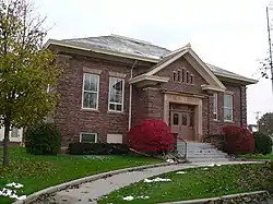 Norfolk Carnegie Library |
December 31, 1998 (#98001567) |
803 W. Norfolk Ave. 42°01′57″N 97°25′04″W |
Norfolk | |
| 8 | St. Leonard's Catholic Church | _complex_from_SW_1.JPG.webp) St. Leonard's Catholic Church |
November 27, 1989 (#89002038) |
502-504 S. Nebraska St. 41°49′33″N 97°27′10″W |
Madison | |
| 9 | Stubbs-Ballah House | 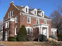 Stubbs-Ballah House |
December 31, 2013 (#13001021) |
1000 Prospect Ave. 42°02′12″N 97°25′15″W |
Norfolk | |
| 10 | U.S. Post Office and Courthouse | _5.jpg.webp) U.S. Post Office and Courthouse |
October 9, 1974 (#74001128) |
125 S. 4th St. 42°01′54″N 97°24′39″W |
Norfolk | |
| 11 | John Wesley and Grace Shafer Warrick House | 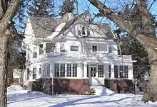 John Wesley and Grace Shafer Warrick House |
November 28, 1990 (#90001767) |
4th St. 42°01′34″N 97°44′14″W |
Meadow Grove |
See also
| Wikimedia Commons has media related to National Register of Historic Places in Madison County, Nebraska. |
References
- The latitude and longitude information provided in this table was derived originally from the National Register Information System, which has been found to be fairly accurate for about 99% of listings. Some locations in this table may have been corrected to current GPS standards.
- "National Register of Historic Places: Weekly List Actions". National Park Service, United States Department of the Interior. Retrieved on January 29, 2021.
- Numbers represent an alphabetical ordering by significant words. Various colorings, defined here, differentiate National Historic Landmarks and historic districts from other NRHP buildings, structures, sites or objects.
- "National Register Information System". National Register of Historic Places. National Park Service. July 9, 2010.
- The eight-digit number below each date is the number assigned to each location in the National Register Information System database, which can be viewed by clicking the number.
| Topics | |
|---|---|
| Lists by state |
|
| Lists by insular areas | |
| Lists by associated state | |
| Other areas | |
| Related | |
| |
Municipalities and communities of Madison County, Nebraska, United States | ||
|---|---|---|
| Cities | Map of Nebraska highlighting Madison County | |
| Village | ||
| Unincorporated communities | ||
| Footnotes | ‡This populated place also has portions in an adjacent county or counties | |
| ||
This article is issued from Wikipedia. The text is licensed under Creative Commons - Attribution - Sharealike. Additional terms may apply for the media files.