Madison County, Nebraska
Madison County is a county in the U.S. state of Nebraska. As of the 2010 United States Census, the population was 34,876.[1] Its county seat is Madison and its largest city is Norfolk.[2] Madison County was named for James Madison, fourth President of the United States.[3]
Madison County | |
|---|---|
_2.JPG.webp) Madison County courthouse in Madison | |
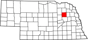 Location within the U.S. state of Nebraska | |
 Nebraska's location within the U.S. | |
| Coordinates: 41°55′N 97°36′W | |
| Country | |
| State | |
| Founded | 1867 |
| Seat | Madison |
| Largest city | Norfolk |
| Area | |
| • Total | 575 sq mi (1,490 km2) |
| • Land | 573 sq mi (1,480 km2) |
| • Water | 2.7 sq mi (7 km2) 0.5%% |
| Population | |
| • Estimate (2018) | 35,392 |
| • Density | 61.3/sq mi (23.7/km2) |
| Time zone | UTC−6 (Central) |
| • Summer (DST) | UTC−5 (CDT) |
| Congressional district | 1st |
| Website | www |
Madison County is part of the Norfolk, NE Micropolitan Statistical Area.
In the Nebraska license plate system, Madison County is represented by the prefix 7 (the county had the seventh-largest number of vehicles registered in the state when the license plate system was established in 1922).
Geography
The terrain in Madison County consists of gently rolling terrain, sloped to the east-southeast, largely devoted to agriculture. The Elkhorn River runs eastward across the upper central portion of the county.[4] The county has a total area of 575 square miles (1,490 km2), of which 573 square miles (1,480 km2) is land and 2.7 square miles (7.0 km2) (0.5%) is water.[5]
Major highways
 U.S. Highway 81
 U.S. Highway 275
 Nebraska Highway 24
 Nebraska Highway 32
 Nebraska Highway 35
 Nebraska Highway 45
 Nebraska Highway 121
Adjacent counties
- Wayne County – northeast
- Stanton County – east
- Platte County – south
- Boone County – southwest
- Antelope County – northwest
- Pierce County – north
Demographics
| Historical population | |||
|---|---|---|---|
| Census | Pop. | %± | |
| 1870 | 1,133 | — | |
| 1880 | 5,589 | 393.3% | |
| 1890 | 13,669 | 144.6% | |
| 1900 | 16,976 | 24.2% | |
| 1910 | 19,101 | 12.5% | |
| 1920 | 22,511 | 17.9% | |
| 1930 | 26,037 | 15.7% | |
| 1940 | 24,269 | −6.8% | |
| 1950 | 24,338 | 0.3% | |
| 1960 | 25,145 | 3.3% | |
| 1970 | 27,402 | 9.0% | |
| 1980 | 31,382 | 14.5% | |
| 1990 | 32,655 | 4.1% | |
| 2000 | 35,226 | 7.9% | |
| 2010 | 34,876 | −1.0% | |
| 2018 (est.) | 35,392 | [8] | 1.5% |
| US Decennial Census[9] 1790-1960[10] 1900-1990[11] 1990-2000[12] 2010-2013[1] | |||
As of the 2000 United States Census,[13] there were 35,226 people, 13,436 households, and 8,894 families in the county. The population density was 62 people per square mile (24/km2). There were 14,432 housing units at an average density of 25 per square mile (10/km2). The racial makeup of the county was 91.35% White, 0.94% Black or African American, 1.19% Native American, 0.40% Asian, 0.03% Pacific Islander, 5.06% from other races, and 1.03% from two or more races. 8.64% of the population were Hispanic or Latino of any race.
There were 13,436 households, out of which 33.20% had children under the age of 18 living with them, 54.70% were married couples living together, 8.40% had a female householder with no husband present, and 33.80% were non-families. 27.90% of all households were made up of individuals, and 12.40% had someone living alone who was 65 years of age or older. The average household size was 2.52 and the average family size was 3.12.
The county population contained 26.80% under the age of 18, 11.60% from 18 to 24, 27.10% from 25 to 44, 20.10% from 45 to 64, and 14.40% who were 65 years of age or older. The median age was 35 years. For every 100 females, there were 98.50 males. For every 100 females age 18 and over, there were 94.80 males.
The median income for a household in the county was $35,807, and the median income for a family was $45,073. Males had a median income of $30,631 versus $21,343 for females. The per capita income for the county was $16,804. About 7.50% of families and 11.20% of the population were below the poverty line, including 13.00% of those under age 18 and 11.50% of those age 65 or over.
Communities
- Battle Creek
- Emerick
- Enola
- Kalamazoo
- Madison (county seat)
- Meadow Grove
- Newman Grove (partial)
- Norfolk
- Tilden (partial)
- Warnerville
Politics
Madison County voters have been strongly Republican for many decades, voting for the Republican candidate in every presidential election except for three from 1900 onward. In addition, no Democratic presidential candidate has won the county since 1936.
| Year | Republican | Democratic | Third Parties |
|---|---|---|---|
| 2020 | 75.5% 11,940 | 22.0% 3,478 | 2.5% 401 |
| 2016 | 74.1% 10,628 | 18.9% 2,711 | 7.0% 1,004 |
| 2012 | 72.5% 10,062 | 25.1% 3,485 | 2.4% 338 |
| 2008 | 68.7% 9,655 | 29.5% 4,142 | 1.8% 248 |
| 2004 | 77.9% 10,981 | 20.8% 2,934 | 1.2% 174 |
| 2000 | 75.0% 9,636 | 21.6% 2,772 | 3.5% 445 |
| 1996 | 63.0% 7,965 | 24.1% 3,047 | 13.0% 1,637 |
| 1992 | 57.1% 7,877 | 17.1% 2,364 | 25.8% 3,555 |
| 1988 | 76.3% 9,137 | 23.2% 2,779 | 0.5% 59 |
| 1984 | 84.5% 9,790 | 15.2% 1,757 | 0.4% 42 |
| 1980 | 78.8% 9,718 | 15.6% 1,926 | 5.6% 685 |
| 1976 | 68.5% 7,846 | 30.0% 3,433 | 1.5% 176 |
| 1972 | 79.4% 8,580 | 20.6% 2,224 | |
| 1968 | 70.4% 7,066 | 23.5% 2,364 | 6.1% 614 |
| 1964 | 56.9% 6,155 | 43.1% 4,661 | |
| 1960 | 73.3% 8,350 | 26.8% 3,050 | |
| 1956 | 73.0% 7,968 | 27.0% 2,949 | |
| 1952 | 76.2% 8,294 | 23.8% 2,589 | |
| 1948 | 62.4% 5,486 | 37.6% 3,304 | |
| 1944 | 67.1% 6,892 | 32.9% 3,373 | |
| 1940 | 64.9% 7,353 | 35.1% 3,982 | |
| 1936 | 45.4% 5,149 | 53.3% 6,044 | 1.3% 147 |
| 1932 | 31.9% 3,489 | 67.2% 7,366 | 0.9% 99 |
| 1928 | 64.3% 6,229 | 35.2% 3,407 | 0.5% 48 |
| 1924 | 40.7% 3,537 | 22.5% 1,959 | 36.8% 3,199 |
| 1920 | 73.3% 5,171 | 24.3% 1,716 | 2.4% 169 |
| 1916 | 49.6% 2,428 | 48.2% 2,358 | 2.3% 111 |
| 1912 | 29.5% 1,181 | 42.9% 1,718 | 27.7% 1,108 |
| 1908 | 52.5% 2,137 | 46.2% 1,878 | 1.3% 54 |
| 1904 | 62.8% 2,210 | 29.8% 1,049 | 7.4% 259 |
| 1900 | 54.1% 2,060 | 44.4% 1,690 | 1.6% 60 |
See also
References
- "State & County QuickFacts". US Census Bureau. Archived from the original on June 7, 2011. Retrieved September 21, 2013.
- "Find a County". National Association of Counties. Retrieved 7 June 2011.
- Chicago and North Western Railway Co. (1908). A History of the Origin of the Place Names Connected with the Chicago & North Western and Chicago, St. Paul, Minneapolis & Omaha Railways. p. 162.
- Madison County NE Google Maps (accessed 23 January 2019)
- "2010 Census Gazetteer Files". US Census Bureau. August 22, 2012. Archived from the original on November 13, 2013. Retrieved December 9, 2014.
- Oak Valley State Wildlife Management Area Google Maps (accessed 23 January 2019)
- Yellowbanks State Wildlife Management Area, Meadow Grove NE Google Maps (accessed 23 January 2019)
- "Population and Housing Unit Estimates". Retrieved December 26, 2019.
- "US Decennial Census". US Census Bureau. Retrieved December 9, 2014.
- "Historical Census Browser". University of Virginia Library. Retrieved December 9, 2014.
- "Population of Counties by Decennial Census: 1900 to 1990". US Census Bureau. Retrieved December 9, 2014.
- "Census 2000 PHC-T-4. Ranking Tables for Counties: 1990 and 2000" (PDF). US Census Bureau. Retrieved December 9, 2014.
- "U.S. Census website". US Census Bureau]]. Retrieved 31 January 2008.
- Election Results
Places adjacent to Madison County, Nebraska | ||||||||||
|---|---|---|---|---|---|---|---|---|---|---|
| ||||||||||
Municipalities and communities of Madison County, Nebraska, United States | ||
|---|---|---|
| Cities | Map of Nebraska highlighting Madison County | |
| Village | ||
| Unincorporated communities | ||
| Footnotes | ‡This populated place also has portions in an adjacent county or counties | |
| ||

| Authority control |
|---|