National Register of Historic Places listings in Merrick County, Nebraska
This is a list of the National Register of Historic Places listings in Merrick County, Nebraska. It is intended to be a complete list of the properties and districts on the National Register of Historic Places in Merrick County, Nebraska, United States. The locations of National Register properties and districts for which the latitude and longitude coordinates are included below, may be seen in a map.[1]
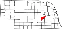
Location of Merrick County in Nebraska
There are 8 properties and districts listed on the National Register in the county.
- This National Park Service list is complete through NPS recent listings posted January 29, 2021.[2]
Current listings
| [3] | Name on the Register | Image | Date listed[4] | Location | City or town | Description |
|---|---|---|---|---|---|---|
| 1 | Cahow Barber Shop | 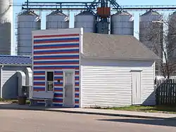 Cahow Barber Shop |
January 12, 1984 (#84002493) |
SW. Main St. 41°01′26″N 98°09′30″W |
Chapman | |
| 2 | Martha Ellen Auditorium | Martha Ellen Auditorium |
September 28, 1988 (#88000944) |
706 C Ave. 41°06′53″N 98°00′09″W |
Central City | |
| 3 | Heber Hord House | 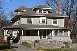 Heber Hord House |
December 7, 1987 (#87002096) |
1505 16th St. 41°06′58″N 97°59′18″W |
Central City | |
| 4 | Wright Morris Boyhood House | Wright Morris Boyhood House |
October 22, 1980 (#80002457) |
304 D St. 41°07′02″N 98°01′38″W |
Central City | |
| 5 | Nelson Farm | _barn_from_SE_1.JPG.webp) Nelson Farm |
August 26, 2009 (#09000650) |
1139 M Rd. 41°06′22″N 98°05′27″W |
Central City | |
| 6 | Palmer Site | _(3).JPG.webp) Palmer Site |
October 15, 1966 (#66000447) |
Address Restricted |
Palmer | Extends into Howard County |
| 7 | Patterson Law Office | 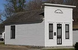 Patterson Law Office |
March 13, 1979 (#79001451) |
1517 18th St. 41°06′51″N 97°59′57″W |
Central City | |
| 8 | Riverside Park Dance Pavilion | 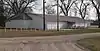 Riverside Park Dance Pavilion |
December 31, 1998 (#98001564) |
Riverside Rd. in Riverside Park 41°05′57″N 97°57′58″W |
Central City |
Former listing
| [3] | Name on the Register | Image | Date listed | Date removed | Location | City or town | Summary |
|---|---|---|---|---|---|---|---|
| 1 | Merrick County Courthouse | 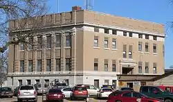 Merrick County Courthouse |
January 10, 1990 (#89002211) | January 2, 2014 | 18th St. between 15th and 16th Aves. 41°06′50″N 97°59′57″W |
Central City |
See also
| Wikimedia Commons has media related to National Register of Historic Places in Merrick County, Nebraska. |
References
- The latitude and longitude information provided in this table was derived originally from the National Register Information System, which has been found to be fairly accurate for about 99% of listings. Some locations in this table may have been corrected to current GPS standards.
- "National Register of Historic Places: Weekly List Actions". National Park Service, United States Department of the Interior. Retrieved on January 29, 2021.
- Numbers represent an alphabetical ordering by significant words. Various colorings, defined here, differentiate National Historic Landmarks and historic districts from other NRHP buildings, structures, sites or objects.
- The eight-digit number below each date is the number assigned to each location in the National Register Information System database, which can be viewed by clicking the number.
| Topics | |
|---|---|
| Lists by state |
|
| Lists by insular areas | |
| Lists by associated state | |
| Other areas | |
| Related | |
| |
Municipalities and communities of Merrick County, Nebraska, United States | ||
|---|---|---|
| City | Map of Nebraska highlighting Merrick County | |
| Villages | ||
| Townships | ||
| CDP | ||
| Unincorporated communities | ||
| ||
This article is issued from Wikipedia. The text is licensed under Creative Commons - Attribution - Sharealike. Additional terms may apply for the media files.