National Register of Historic Places listings in Noxubee County, Mississippi
This is a list of the National Register of Historic Places listings in Noxubee County, Mississippi.
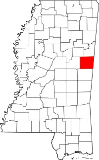
Location of Noxubee County in Mississippi
This is intended to be a complete list of the properties and districts on the National Register of Historic Places in Noxubee County, Mississippi, United States. Latitude and longitude coordinates are provided for many National Register properties and districts; these locations may be seen together in a map.[1]
There are 13 properties and districts listed on the National Register in the county, including 1 National Historic Landmark.
- This National Park Service list is complete through NPS recent listings posted February 5, 2021.[2]
Current listings
| [3] | Name on the Register[4] | Image | Date listed[5] | Location | City or town | Description |
|---|---|---|---|---|---|---|
| 1 | Central Shuqualak Historic District | August 26, 1980 (#80002297) |
Off Mississippi Highway 39 32°58′47″N 88°34′01″W |
Shuqualak | ||
| 2 | Dancing Rabbit Creek Treaty Site | 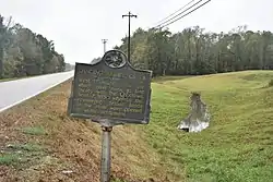 Dancing Rabbit Creek Treaty Site |
April 3, 1973 (#73001024) |
Around Dancing Rabbit Spring, southwest of Macon[6] 33°00′35″N 88°45′15″W |
Macon | |
| 3 | Flora House | December 2, 1982 (#82000577) |
Line St. 32°58′40″N 88°34′18″W |
Shuqualak | ||
| 4 | Goodwin-Harrison House | .jpg.webp) Goodwin-Harrison House |
November 28, 1980 (#80002296) |
213 N. Jefferson St. 33°06′48″N 88°33′37″W |
Macon | |
| 5 | Macon Historic District |  Macon Historic District |
March 21, 2002 (#02000207) |
Roughly bounded by Adams, Pearl, West, and Wayne Sts. 33°07′09″N 88°33′39″W |
Macon | |
| 6 | Maudwin | 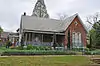 Maudwin |
August 29, 1985 (#85001929) |
101 Washington St. 33°06′36″N 88°33′32″W |
Macon | |
| 7 | McGeehee-Ames House | 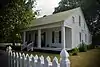 McGeehee-Ames House |
July 10, 1992 (#92000853) |
Magnolia Dr. south of its junction with U.S. Route 45 33°08′29″N 88°33′20″W |
Macon | |
| 8 | Old Noxubee County Jail | 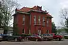 Old Noxubee County Jail |
January 8, 1979 (#79001333) |
209 Monroe St. 33°06′22″N 88°33′38″W |
Macon | |
| 9 | Old Noxubee County Jail of 1870 | 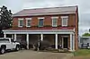 Old Noxubee County Jail of 1870 |
January 3, 1991 (#90002102) |
503 S. Washington St. 33°06′02″N 88°33′35″W |
Macon | |
| 10 | Running Water Creek Bridge | November 16, 1988 (#88002487) |
Spans Running Water Creek on a county road 33°01′05″N 88°36′50″W |
Shuqualak | ||
| 11 | Old Salem School | 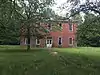 Old Salem School |
January 26, 1990 (#89002323) |
3.4 miles west of Macon on Mississippi Highway 14 33°05′42″N 88°36′51″W |
Macon | |
| 12 | William Henry Scales House | 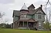 William Henry Scales House |
August 9, 2002 (#02000858) |
1108 Magnolia Dr. 33°07′58″N 88°33′20″W |
Macon | |
| 13 | Yates-Flora House | .jpg.webp) Yates-Flora House |
December 2, 1982 (#82000578) |
100 N. Wayne St. 33°06′37″N 88°33′28″W |
Macon |
See also
| Wikimedia Commons has media related to National Register of Historic Places in Noxubee County, Mississippi. |
References
- The latitude and longitude information provided in this table was derived originally from the National Register Information System, which has been found to be fairly accurate for about 99% of listings. Some locations in this table may have been corrected to current GPS standards.
- "National Register of Historic Places: Weekly List Actions". National Park Service, United States Department of the Interior. Retrieved on February 5, 2021.
- Numbers represent an alphabetical ordering by significant words. Various colorings, defined here, differentiate National Historic Landmarks and historic districts from other NRHP buildings, structures, sites or objects.
- "National Register Information System". National Register of Historic Places. National Park Service. March 13, 2009.
- The eight-digit number below each date is the number assigned to each location in the National Register Information System database, which can be viewed by clicking the number.
- Location derived from its NHL nomination form; the NRIS lists the site as "Address Restricted"
| Topics | |
|---|---|
| Lists by state |
|
| Lists by insular areas | |
| Lists by associated state | |
| Other areas | |
| Related | |
| |
Municipalities and communities of Noxubee County, Mississippi, United States | ||
|---|---|---|
| City | Map of Mississippi highlighting Noxubee County | |
| Towns | ||
| Unincorporated communities |
| |
| ||
This article is issued from Wikipedia. The text is licensed under Creative Commons - Attribution - Sharealike. Additional terms may apply for the media files.
