National Register of Historic Places listings in Olympic National Park
This is a list of the National Register of Historic Places listings in Olympic National Park.
This is intended to be a complete list of the properties and districts on the National Register of Historic Places in Olympic National Park, Washington, United States. The locations of National Register properties and districts for which the latitude and longitude coordinates are included below, may be seen in a Google map.[1]
There are 33 properties and districts listed on the National Register in the park.
- This National Park Service list is complete through NPS recent listings posted January 29, 2021.[2]
Current listings
| [3] | Name on the Register[4] | Image | Date listed[5] | Location | City or town | Description |
|---|---|---|---|---|---|---|
| 1 | Altair Campground Community Kitchen | 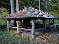 Altair Campground Community Kitchen |
July 13, 2007 (#07000732) |
Along Elwha River, about 3.4 miles (5.5 km) south of Elwha 48°00′41″N 123°35′34″W |
Port Angeles | Campground central kitchen built by the Civilian Conservation Corps. Possibly damaged by flood in November 2015. |
| 2 | Botten Cabin | 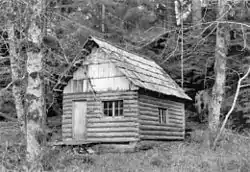 Botten Cabin |
July 13, 2007 (#07000729) |
20.9 mi. from Whiskey Bend Trailhead on the Elwha River Trail 47°45′50″N 123°27′16″W |
Port Angeles | |
| 3 | Canyon Creek Shelter | 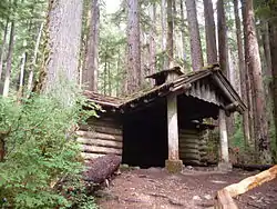 Canyon Creek Shelter |
July 13, 2007 (#07000712) |
About 0.68 miles (1.09 km) from Sol Duc Trailhead, and about 21.3 miles (34.3 km) southwest of Port Angeles 47°57′08″N 123°49′15″W |
Port Angeles | Rustic trail shelter |
| 4 | Dodger Point Fire Lookout | 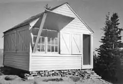 Dodger Point Fire Lookout |
July 13, 2007 (#07000736) |
Mile 13 of Dodger Point Trail, about 17.2 miles (27.7 km) south of Port Angeles 47°52′27″N 123°30′36″W |
Port Angeles | |
| 5 | Eagle Ranger Station | 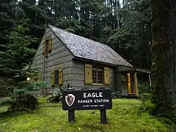 Eagle Ranger Station |
July 13, 2007 (#07000713) |
Along Upper Sol Duc Road, about 22.4 miles (36.0 km) southwest of Port Angeles 47°58′20″N 123°51′52″W |
Port Angeles | |
| 6 | Elkhorn Guard Station | July 13, 2007 (#07000714) |
Along Elwha River Trail, about 14.3 miles (23.0 km) south of Elwha 47°52′23″N 123°28′10″W |
Port Angeles | ||
| 7 | Elk Lick Lodge | July 13, 2007 (#07000734) |
13 mi. from Whiskey Bend Trailhead on the Elwha River Trail 47°51′26″N 123°28′09″W |
Port Angeles | ||
| 8 | Elwha Campground Community Kitchen | 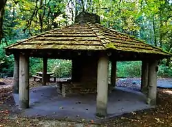 Elwha Campground Community Kitchen |
July 13, 2007 (#07000735) |
Along Elwha River, about 2.3 miles (3.7 km) south of Elwha 48°01′40″N 123°35′17″W |
Port Angeles | Campground kitchen built by the Civilian Conservation Corps. Possibly damaged by flood in November 2015. |
| 9 | Elwha Ranger Station | 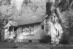 Elwha Ranger Station |
July 13, 2007 (#07000716) |
Along Elwha River, about 3 miles (4.8 km) south of Elwha 48°00′59″N 123°35′26″W |
Port Angeles | |
| 10 | Enchanted Valley Chalet | 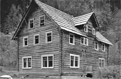 Enchanted Valley Chalet |
July 13, 2007 (#07000737) |
13 mi. upriver from Graves Cr. Trailhead 47°40′31″N 123°23′21″W |
Port Angeles | Backcountry concessioner lodge, now threatened by deterioration and shifting river channels |
| 11 | Fifteen Mile Shelter | July 13, 2007 (#07000715) |
Along North Fork Bogachiel River Trail, about 31 miles (50 km) southwest of Port Angeles 47°54′10″N 124°01′19″W |
Port Angeles | ||
| 12 | Glines Canyon Hydroelectric Power Plant | 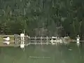 Glines Canyon Hydroelectric Power Plant |
December 15, 1988 (#88002742) |
On Elwha River, along Olympic Hot Springs Road, about 11 miles (18 km) southwest of Port Angeles 48°00′07″N 123°36′00″W |
Port Angeles | Dam demolished in 2012. |
| 13 | Graves Creek Ranger Station | 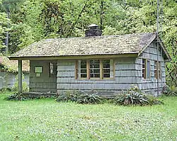 Graves Creek Ranger Station |
July 13, 2007 (#07000717) |
Approx. 22 mi. NE of WA 101 on Quinault River Rd. 47°34′09″N 123°34′40″W |
Port Angeles | |
| 14 | Happy Four Shelter | July 13, 2007 (#07000719) |
Approx. 5.4 along Hoh River Trail 47°52′06″N 123°49′41″W |
Port Angeles | ||
| 15 | Hayes River Fire Cache | July 13, 2007 (#07000738) |
Approx. 16.8 mi. up the Elwha River Trail 47°48′34″N 123°27′09″W |
Port Angeles | ||
| 16 | Humes Ranch Cabin | 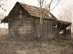 Humes Ranch Cabin |
September 14, 1977 (#77001332) |
On Elwha River, along Geyser Valley trail, about 12.7 miles (20.4 km) southwest of Port Angeles 47°56′59″N 123°32′48″W |
Port Angeles | |
| 17 | Hyak Shelter | July 13, 2007 (#07000721) |
Along North Fork Bogachiel River Trail, about 28.4 miles (45.7 km) southwest of Port Angeles 47°55′22″N 123°58′24″W |
Port Angeles | Included in the Olympic National Park MPS. | |
| 18 | Kestner Homestead | 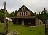 Kestner Homestead |
July 13, 2007 (#07000741) |
Quinault River Valley, .5 mi. N of Quinault River Ranger Station, along west side of Kestner Creek, Quinault sub-distr 47°30′32″N 123°49′03″W |
Port Angeles | |
| 19 | Michael's Cabin | July 13, 2007 (#07000733) |
Along Elwha River Trail, about 7.7 miles (12.4 km) southeast of Elwha, in Olympic National Forest 47°57′11″N 123°33′15″W |
Port Angeles | Included in the Olympic National Park MPS. | |
| 20 | North Fork Quinault Ranger Station | 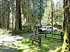 North Fork Quinault Ranger Station |
July 13, 2007 (#07000718) |
Approx. 18 mi. NE of WA 101 on N. Fork Rd. off N. Shore Quinault Rd. 47°34′26″N 123°38′50″W |
Port Angeles | |
| 21 | North Fork Sol Duc Shelter | July 13, 2007 (#07000725) |
Along North Fork Sol Duc River Trail, about 17.3 miles (27.8 km) southwest of Port Angeles 47°59′59″N 123°45′48″W |
Port Angeles | Rustic trail shelter | |
| 22 | Olympic National Park Headquarters Historic District | 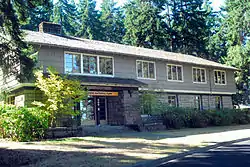 Olympic National Park Headquarters Historic District |
July 13, 2007 (#07000720) |
600 East Park Avenue 48°05′59″N 123°25′57″W |
Port Angeles | |
| 23 | Olympus Guard Station | November 5, 2007 (#07000722) |
Approx. 9 mi. from Hoh River Trailhead at Hoh Ranger Station 47°52′35″N 123°45′52″W |
Port Angeles | ||
| 24 | Ozette Indian Village Archeological Site | 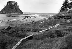 Ozette Indian Village Archeological Site |
January 11, 1974 (#74000916) |
Address restricted[6] |
La Push | |
| 25 | Pelton Creek Shelter | July 13, 2007 (#07000727) |
Approximately 15.5 miles (24.9 km) up the Queets River Trail 47°42′09″N 123°45′48″W |
Port Angeles | ||
| 26 | Pyramid Peak Aircraft Warning Service Lookout | 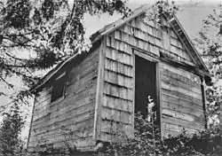 Pyramid Peak Aircraft Warning Service Lookout |
July 13, 2007 (#07000726) |
End of Pyramid Peak Trail, about 17.6 miles (28.3 km) west of Port Angeles, Washington 48°04′28″N 123°48′28″W |
Port Angeles | Purpose-built station for early warning of airborne intruders during World War II |
| 27 | Peter Roose Homestead | .JPG.webp) Peter Roose Homestead |
July 13, 2007 (#07000723) |
About 0.4 miles (0.64 km) north of Cape Alava Trail, 1.9 miles (3.1 km) west of Ozette 48°09′42″N 124°42′25″W |
Port Angeles | |
| 28 | Rosemary Inn | 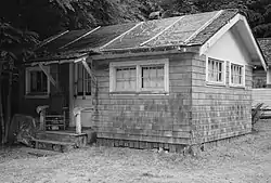 Rosemary Inn |
July 17, 1979 (#79001033) |
East of Barnes Point, on south shore of Lake Crescent, about 17.2 miles (27.7 km) southwest of Port Angeles 48°03′35″N 123°47′39″W |
Port Angeles | |
| 29 | Singer's Lake Crescent Tavern | 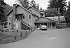 Singer's Lake Crescent Tavern |
July 13, 2007 (#07000724) |
South of Barnes Point, on south shore of Lake Crescent, about 17.4 miles (28.0 km) southwest of Port Angeles 48°03′26″N 123°47′57″W |
Port Angeles | |
| 30 | Storm King Ranger Station | 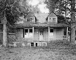 Storm King Ranger Station |
July 13, 2007 (#07000730) |
Southeast of Barnes Point, on south shore of Lake Crescent, about 17 miles (27 km) southwest of Port Angeles 48°03′28″N 123°47′19″W |
Port Angeles | |
| 31 | Three Forks Shelter | July 13, 2007 (#07000728) |
At confluence of Grand Creek and Cameron Creek, along Three Forks Trail, about 13.2 miles (21.2 km) southwest of Sequim 47°54′56″N 123°14′52″W |
Sequim | Included in the Olympic National Park MPS. | |
| 32 | Wedding Rock Petroglyphs | 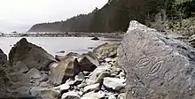 Wedding Rock Petroglyphs |
April 3, 1976 (#76000951) |
Address restricted[6] |
Forks | |
| 33 | Wendel Property | July 13, 2007 (#07000739) |
3723 East Beach Road, 0.5 miles (0.80 km) west of Piedmont, about 17.2 miles (27.7 km) west of Port Angeles 48°05′41″N 123°48′07″W |
Port Angeles |
See also
References
- Evans, Gail E.H.; Toothman, Stephanie; Luxenberg, Gretchen; Wray, Jacilee. National Register of Historic Places Multiple Property Documentation Form:Historic Resources of Olympic National Park. National Park Service 1986, 1998, 2005
- The latitude and longitude information provided in this table was derived originally from the National Register Information System, which has been found to be fairly accurate for about 99% of listings. Some locations in this table may have been corrected to current GPS standards.
- "National Register of Historic Places: Weekly List Actions". National Park Service, United States Department of the Interior. Retrieved on January 29, 2021.
- Numbers represent an alphabetical ordering by significant words. Various colorings, defined here, differentiate National Historic Landmarks and historic districts from other NRHP buildings, structures, sites or objects.
- "National Register Information System". National Register of Historic Places. National Park Service. April 24, 2008.
- The eight-digit number below each date is the number assigned to each location in the National Register Information System database, which can be viewed by clicking the number.
- Federal and state laws and practices restrict general public access to information regarding the specific location of this resource. In some cases, this is to protect archeological sites from vandalism, while in other cases it is restricted at the request of the owner. See: Knoerl, John; Miller, Diane; Shrimpton, Rebecca H. (1990), Guidelines for Restricting Information about Historic and Prehistoric Resources, National Register Bulletin, National Park Service, U.S. Department of the Interior, OCLC 20706997.
External links
| Wikimedia Commons has media related to National Register of Historic Places in Olympic National Park. |
| Topics | |
|---|---|
| Lists by state |
|
| Lists by insular areas | |
| Lists by associated state | |
| Other areas | |
| Related | |
| |
This article is issued from Wikipedia. The text is licensed under Creative Commons - Attribution - Sharealike. Additional terms may apply for the media files.